
Tam McArthur Rim Trail
A challenging 9+ mile hike offering breathtaking panoramic views of the Central Oregon Cascades, including Broken Top and Three Creeks Lake.
Highlights
Must-see attractions

Social
From TikTok & Reddit
Best Time
Cooler temps, fewer crowds
Tam McArthur Rim Trail
Best Time
Cooler temps, fewer crowds
Highlights
Must-see attractions
A challenging 9+ mile hike offering breathtaking panoramic views of the Central Oregon Cascades, including Broken Top and Three Creeks Lake.
"One of the most beautiful and breathtaking day-hikes I’ve ever been on."
🚗 High Clearance Vehicle Needed
Forest Road 370 can be rough. A 4WD or high-clearance vehicle is highly recommended for safe access .
🧥 Layer Up for Temperature Swings
Even in June, expect a significant temperature drop. Pack layers to stay comfortable in sunshine and potential snow .
Quick Facts
Hours
Rating
4.8 · 102 reviews
Type
Hiking Area
Highlights
Discover the most iconic attractions and experiences
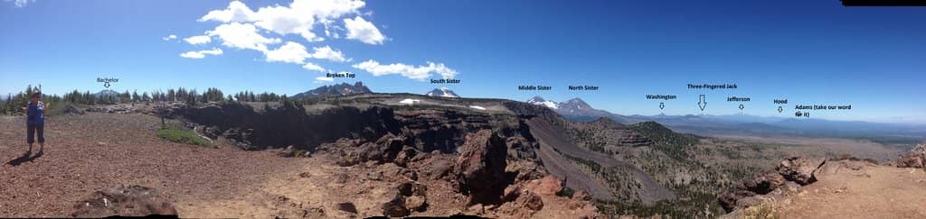
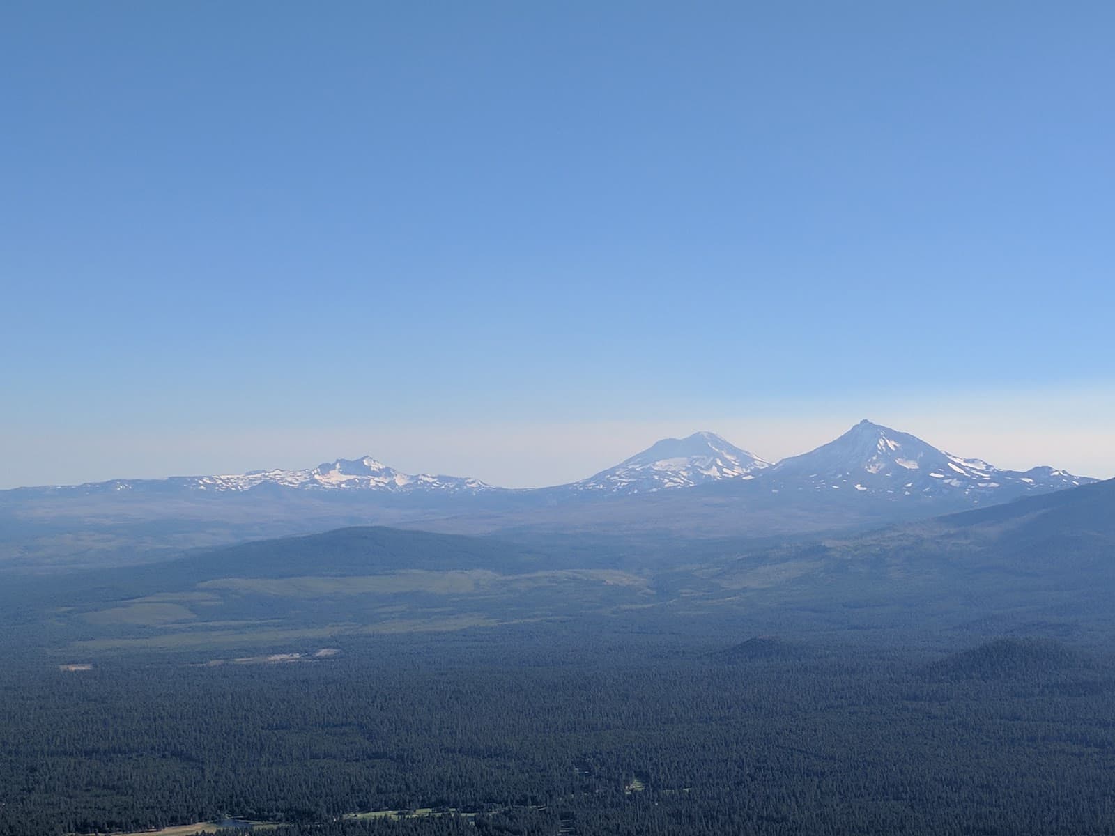
Tam McArthur Rim Panorama
End of the Rim Trail
A breathtaking panoramic view north from the cliff face, showcasing the vast Central Oregon landscape.

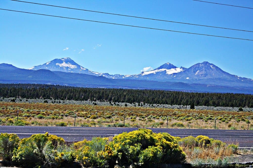
Broken Top & Cascade Views
Along the trail and at the rim
Unobstructed vistas of the Central Oregon Cascade mountains, including Broken Top up close and even Mt. Hood on clear days.
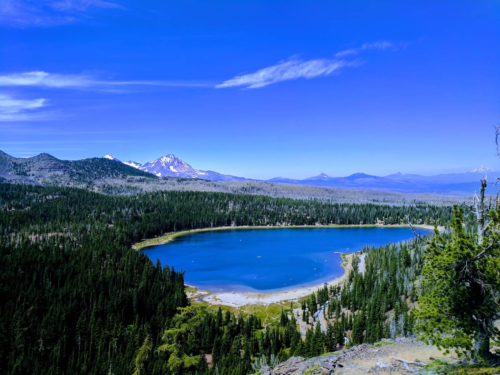
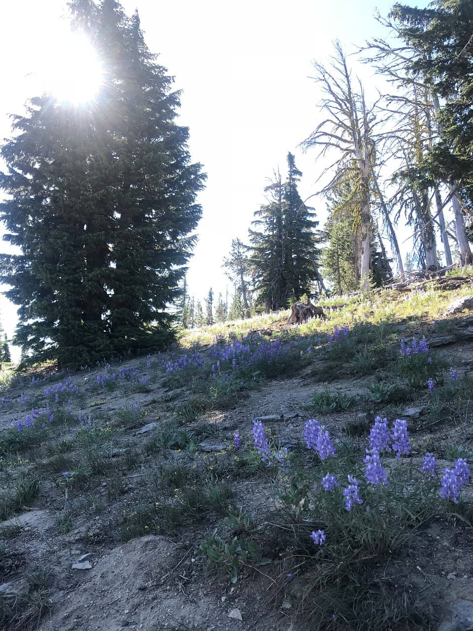
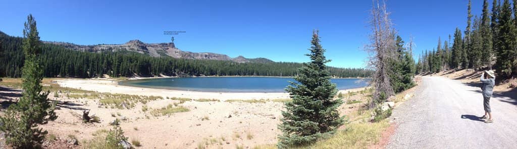
Three Creeks Lake & Surrounds
Visible from the trail
Stunning views of Three Creeks Lake and the surrounding landscape, with glimpses towards Sisters and Black Butte.
Optional Extension to Broken Hand
Beyond the Rim Trail
For the energetic, continue to Broken Hand for expansive views of the Sisters, Broken Top, and Mt. Bachelor.
Plans like a pro.
Thinks like you
Planning Your Visit
Road Access & Conditions
Trail Length & Difficulty
Best Times
Insider Tips
from TikTok, Instagram & Reddit
Hiking Broken Top
Hello, ​ I am planning a trip to hike to Broken Top soon. I know my car would not be able to make it up the bumpy road to the closer trailhead so I had a few questions for those who can help! ​ \- If you start at Todds Lake trailhead, how well marked…
🚗 High Clearance Vehicle Needed
Forest Road 370 can be rough. A 4WD or high-clearance vehicle is highly recommended for safe access.
🧥 Layer Up for Temperature Swings
Even in June, expect a significant temperature drop. Pack layers to stay comfortable in sunshine and potential snow.
Forest Road 370 - Anyone made it to Broken Top?
Deschutes NF site has not been updated since 7/21/25 and still shows closed. Recreation.Gov now says road is open with 4wd/High Clearance recommendation. Anyone noticed if the gate at Todd Lake trailhead has been open in the last week?
💧 Bring Plenty of Water
This is a strenuous hike. Carry more water than you think you'll need, especially during warmer months.
🥾 Sturdy Hiking Boots Essential
The trail has varied terrain and elevation gain. Good ankle support and grip are crucial for a comfortable hike.
Tips
from all over the internet
🚗 High Clearance Vehicle Needed
Forest Road 370 can be rough. A 4WD or high-clearance vehicle is highly recommended for safe access.
🧥 Layer Up for Temperature Swings
Even in June, expect a significant temperature drop. Pack layers to stay comfortable in sunshine and potential snow.
💧 Bring Plenty of Water
This is a strenuous hike. Carry more water than you think you'll need, especially during warmer months.
🥾 Sturdy Hiking Boots Essential
The trail has varied terrain and elevation gain. Good ankle support and grip are crucial for a comfortable hike.
🗺️ Download Offline Maps
Cell service can be spotty. Download trail maps beforehand to ensure you stay on track.
What Travellers Say
Reviews Summary
Hikers consistently rave about the Tam McArthur Rim Trail, calling it one of the most beautiful and breathtaking hikes they've ever experienced. The panoramic views of the Central Oregon Cascades, including Broken Top and Three Creeks Lake, are a major highlight. While the trail is strenuous with significant elevation gain, most agree the effort is well worth the unforgettable scenery.
"Tam McArthur Rim to Broken Hand is the most beautiful and breathtaking day-hikes I’ve ever been on. I told my wife, if it wasn’t so remote I would request my ashes spread here (I know illegal).
It’s a 9+ mile round trip hike with nearly 1,800 feet elevation gain though most is in the first 2 miles. All of the Central Oregon Cascade mountains are visible with Broken Top up close. Skies were clear enough to get a view of Mt. Hood.
Trail maps will tell you it takes 5 - 5 1/2 hours to complete. It took my wife and I (late 50’s) seven hours."
Brian Johnson
"Always amazing views. One of the best one day 25 mile hikes in Oregon."
Kevin Pico
"Its a great hike with wonderful view."
David Moore
What People Like
What People Dislike
Frequently Asked Questions
🚇 🗺️ Getting There
The primary access is via Forest Road 370. Be aware that this road can be rough and often requires a 4WD or high-clearance vehicle. Always check the Deschutes National Forest website for the most current road conditions and closures before your trip.
No, Forest Road 370's opening status can vary. While Recreation.Gov might list it as open, it's crucial to verify with the Deschutes National Forest site, as it may have specific access recommendations or be subject to closures due to snow or maintenance.
It's generally not recommended. The road conditions are often described as requiring high clearance and 4WD. A standard sedan may struggle with the terrain, potentially leading to damage.
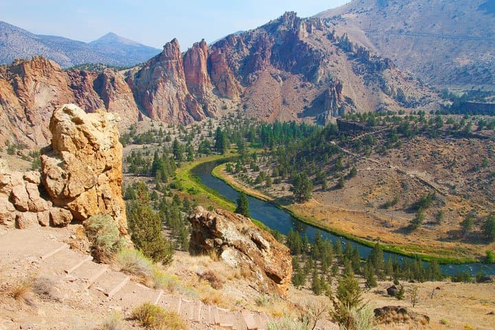
The trail is located in the Three Sisters Wilderness area. Redmond is a nearby town, and Bend is a larger city within a reasonable driving distance for supplies and accommodation.
Currently, there are no widely advertised shuttle services directly to the Tam McArthur Rim Trailhead. It's best to plan for private transportation.
🎫 🎫 Tickets & Entry
Yes, a Central Cascades Wilderness Permit is required for day hikes and overnight stays in the Three Sisters Wilderness, including the Tam McArthur Rim Trail area. These permits are often in high demand and need to be reserved in advance through Recreation.Gov.
Permit fees vary depending on the type of permit (day use vs. overnight) and the season. Check Recreation.Gov for the most up-to-date pricing information.
The trail is generally accessible during daylight hours, but access is dependent on road conditions and weather. There are no set operating hours for the trail itself, but permits may have time restrictions.
It's highly recommended to secure your permit online in advance via Recreation.Gov, as they are often limited and sell out quickly, especially during peak season. On-site availability is not guaranteed.
Hiking without a required permit can result in fines. It's essential to obtain the correct permit before your visit to avoid any issues.
🎫 🥾 Onsite Experience
The hike is approximately 9+ miles round trip with significant elevation gain. While trail maps might suggest 5-5.5 hours, many hikers, including those in their late 50s, report taking up to seven hours to complete it comfortably and enjoy the views.
The trail features nearly 1,800 feet of elevation gain, with the majority of it concentrated in the first two miles. Be prepared for a strenuous uphill climb.
Expect absolutely breathtaking views! You'll see the Central Oregon Cascade mountains, including Broken Top up close, Three Creeks Lake, and on clear days, even Mt. Hood. The cliff face at the end of the rim trail offers a stunning panoramic vista.
The trail is generally well-defined, but it's always a good idea to carry a map and compass or use a GPS device, especially as you get closer to the rim. Downloading offline maps is highly recommended due to limited cell service.
Typically, there are vault toilets available at the trailhead, but it's always wise to confirm this with recent visitor reports or the Forest Service.
📸 📸 Photography
The entire trail offers incredible photo opportunities. The panoramic view from the end of the rim trail is a must-capture. Also, look for shots of Broken Top, Three Creeks Lake, and the expansive mountain ranges. The changing light throughout the day can create dramatic scenes.
Early morning and late afternoon offer the best light for landscape photography, with softer shadows and warmer hues. However, the dramatic mountain vistas are impressive at any time on a clear day.
A wide-angle lens is great for capturing the sweeping panoramas. A telephoto lens can be useful for isolating mountain peaks. Don't forget a sturdy tripod if you plan on shooting during sunrise or sunset.
Drone usage is restricted in many wilderness areas, including the Three Sisters Wilderness. It's essential to check current regulations with the Forest Service before flying a drone to avoid violations.
Include a person or a recognizable object in your frame to give a sense of scale. Shooting from different vantage points along the trail can also help convey the vastness of the landscape.


Social
from TikTok, Instagram & Reddit