
Kitsuma Peak Trail
Conquer steep switchbacks on Kitsuma Peak Trail for breathtaking mountain vistas in Pisgah National Forest. A rewarding hike for the adventurous.
Highlights
Must-see attractions

Social
From TikTok & Reddit
Best Time
Cooler temps, vibrant foliage
Kitsuma Peak Trail
Best Time
Cooler temps, vibrant foliage
Highlights
Must-see attractions
Conquer steep switchbacks on Kitsuma Peak Trail for breathtaking mountain vistas in Pisgah National Forest. A rewarding hike for the adventurous.
"Amazing hike. Worth it in all seasons to see at the 'secret' overlook."

Download Offline Maps 🗺️
Signage is minimal at the top. Ensure you have offline maps downloaded for navigation.
Wear Sturdy Footwear 👟
Rocky terrain and roots are common. Avoid sandals; opt for hiking boots or trail shoes.

Highlights
Discover the most iconic attractions and experiences
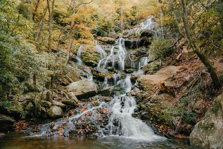
Kitsuma Peak Summit
Summit of Kitsuma Peak
Reach the 3,159-foot summit for panoramic views of rolling mountains and a sense of accomplishment.
The 'Secret' Overlook
On the ascent to Kitsuma Peak
Discover a less-obvious, rewarding viewpoint offering stunning mountain vistas, a true hidden gem.

Switchback Challenge
Ascent from Black Mountain side
Conquer approximately 12 challenging switchbacks on the steep initial climb, a true test of endurance.
Plans like a pro.
Thinks like you
Planning Your Visit
Trail Navigation & Signage
Footwear & Trail Conditions
Best Times
Insider Tips
from TikTok, Instagram & Reddit
Old Fort MTB trails next weekend
Download Offline Maps 🗺️
Signage is minimal at the top. Ensure you have offline maps downloaded for navigation.
Wear Sturdy Footwear 👟
Rocky terrain and roots are common. Avoid sandals; opt for hiking boots or trail shoes.
I am visiting the Pisgah National Forest area and staying in Brevard NC. Are there any trails that are a must hit I have 5 days there? I would love some flowy smooth stuff but also would like some middle of the pack technical stuff.
Besides bent creek, where's some good places to mountain bike around the area?
Check Weather Forecast ☀️
Fair weather makes the steep climb more enjoyable. Be prepared for changing conditions in Pisgah National Forest.
Consider a Loop Hike 🔄
Combine Kitsuma Peak with Point Lookout Trail for a longer, varied adventure.
Anybody have a favorite day hike around Black Mountain?
Tips
from all over the internet
Download Offline Maps 🗺️
Signage is minimal at the top. Ensure you have offline maps downloaded for navigation.
Wear Sturdy Footwear 👟
Rocky terrain and roots are common. Avoid sandals; opt for hiking boots or trail shoes.
Check Weather Forecast ☀️
Fair weather makes the steep climb more enjoyable. Be prepared for changing conditions in Pisgah National Forest.
Consider a Loop Hike 🔄
Combine Kitsuma Peak with Point Lookout Trail for a longer, varied adventure.
Bring Water & Snacks 💧
It's a moderate to strenuous hike. Stay hydrated and fueled, especially on warmer days.
What Travellers Say
Reviews Summary
Kitsuma Peak Trail is praised for its challenging ascent and rewarding mountain views, with many appreciating the 'secret' overlook. While the trail offers a good workout and reliable cell service, some visitors note the lack of clear signage at the summit, making navigation tricky. Proper footwear is essential due to the rocky and root-filled terrain.
"Amazing hike. Worth it in all seasons to see at the “secret” overlook (i see a few pics of the “decoy one” posted lol).
Amazing views especially the rolling Mountains, where I got centered spiritually and started on my weight loss journey (diet is more important than exercise though) & lost over 160 pounds so far.
Attaching a picture of the overview"
Remy G
"Nice moderate trail. Good place to park easy to get in and out of. The only thing I would really say is there's really no markers when you get to the top of the hill of where to go or how far things are from places. Head cell service the entire time I was there so that's a good thing."
Edward Deaton
"A nice trail, within Pisgah National Forest, that runs from Black Mountain down to Old Fort. From the Black Mountain side, the trail starts off easy with a gentle climb alongside Interstate 40 for about 0.3 miles before turning steep. After another 0.7 miles, and about 12 switchbacks, you'll reach the top of Kitsuma Peak (3,159 feet). Note - There's a nice little outcropping and view on your way up to Kitsuma Peak.
The complete trail (to Old Fort) is about 4.5 miles. The first mile gets you to the top of Kitsuma, then it's rolling hills of another 0.7 miles before a long descent (about 2.8 miles) to Old Fort Picnic Area. I made a big loop taking Point Lookout Trail the way back up which requires some walking along Mill Creek Road but it was fun."
Rocky Bilotta
What People Like
What People Dislike
Frequently Asked Questions
🚇 🗺️ Getting There
The trail starts near Black Mountain. From the Black Mountain side, the trail begins with a gentle climb alongside Interstate 40 for about 0.3 miles before becoming steep. Parking is generally easy to access.
Yes, the complete trail runs from Black Mountain down to Old Fort. The descent to the Old Fort Picnic Area is about 2.8 miles after the initial climb and rolling hills.
Yes, reviewers mention good parking availability that is easy to get in and out of.
Absolutely! You can connect to trails like Gateway trails via Rostan trail, and even make a loop using Point Lookout Trail.
Camp Grier Road is mentioned as a potential shortcut to get to Gateway trails, and it is considered viable by some riders.
🎫 🎫 Tickets & Entry
No, Kitsuma Peak Trail is located within Pisgah National Forest and typically does not require an entrance fee or ticket for hiking. Always check current forest service regulations before your visit.
As an outdoor trail, Kitsuma Peak Trail is generally accessible from dawn to dusk. There are no set operating hours, but it's best to hike during daylight for safety and enjoyment.
There is no specific admission fee for Kitsuma Peak itself, as it's part of the natural landscape within Pisgah National Forest. Standard National Forest access rules apply.
While not as common as for major attractions, some local outdoor outfitters may offer guided hikes. It's advisable to search for local tour operators in the Black Mountain or Old Fort area.
Typically, no special permits are required for day hiking on Kitsuma Peak Trail. However, if you plan on overnight camping or specific activities, check with the Pisgah National Forest Service for any necessary permits.
🎫 🧭 Onsite Experience
Reviewers generally describe it as a moderate to strenuous hike. The initial mile involves a steep incline with about 12 switchbacks, followed by rolling hills. A difficulty of 3/5 is a common assessment.
The first mile to the top of Kitsuma Peak takes about 45 minutes for many hikers. The complete trail to Old Fort is about 4.5 miles one way.
Signage can be minimal, especially at the top, leading to confusion about directions. It's recommended to have a map or GPS device.
Expect amazing views of rolling mountains. There's a nice overlook on the way up, and the summit offers rewarding panoramic vistas.
Some suggest it's possible to ride with a child, implying it can be manageable for older, more experienced children, but the steep sections and rocky terrain require caution.
📸 📸 Photography
The summit offers expansive mountain views, and there's a notable 'secret' overlook on the ascent that provides stunning photo opportunities. The switchbacks themselves can also make for dramatic shots.
Yes, cell service is generally available throughout the hike, which is helpful for sharing photos or using navigation apps.
Mornings and late afternoons often provide the best light for landscape photography, with softer shadows and warmer tones. Golden hour can be particularly magical.
Drone usage in National Forests is regulated. You'll need to check current FAA and Pisgah National Forest regulations regarding drone operation, which often requires permits and adherence to specific rules.
A wide-angle lens is great for capturing the expansive mountain vistas. A sturdy tripod can be useful for low-light conditions or capturing long exposures. Don't forget a protective case for your gear.
For Different Travelers
Tailored advice for your travel style
👨👩👧 Families with Kids
⛰️ Avid Hikers & Trail Runners
🚴 Mountain Bikers
Deep Dives
In-depth insights and expert knowledge
The Kitsuma Peak Trail Experience
While the trail is generally well-maintained, reviewers note that signage can be sparse, particularly at the peak, which can lead to confusion about the best path forward. Cell service is typically reliable, making it easier to use navigation apps, but downloading offline maps is still a prudent measure. The terrain is characterized by rocky sections and exposed roots, making sturdy footwear essential. The trail can be extended by continuing towards Old Fort, or by creating loops with adjacent trails like Point Lookout Trail, offering varied hiking experiences.
Many visitors find the 'secret' overlook on the way up to be a highlight, offering a more secluded and equally stunning view compared to the main summit. The trail's moderate to strenuous difficulty makes it a good option for those seeking a physical challenge with a beautiful payoff. It's a place where personal journeys, like weight loss, have been inspired by the natural beauty and the sense of achievement.
Connecting Trails and Extended Adventures
Another popular option for creating a loop is by incorporating the Point Lookout Trail. This can involve some walking along Mill Creek Road to complete the circuit, but it provides a diverse experience, moving from the steep climbs of Kitsuma to potentially different forest environments. The ability to create these varied loops is a significant draw for those looking to spend more time exploring the area.
For those looking for shortcuts or alternative access points, Camp Grier Road has been mentioned as a viable route to connect to the Gateway trails. This highlights the interconnectedness of the trail system and the flexibility it offers to tailor an outing to your desired length and difficulty. Always be sure to consult trail maps and local advice for the best routes and conditions.


Social
from TikTok, Instagram & Reddit