
Seeley Creek Trail Heart Rock
A scenic 1.8-mile loop trail in Crestline, CA, leading to a unique heart-shaped rock beside a 20-ft waterfall.

Highlights
Must-see attractions

Social
From TikTok & Reddit
Best Time
For a roaring waterfall
Seeley Creek Trail Heart Rock
Best Time
For a roaring waterfall
Highlights
Must-see attractions
A scenic 1.8-mile loop trail in Crestline, CA, leading to a unique heart-shaped rock beside a 20-ft waterfall.
"A hidden gem in the San Bernardino National Forest, perfect for nature lovers and a refreshing escape."
🚗 Parking Advice
Park in the dirt patch near Camp Seeley. Google Maps is accurate, even if marked closed .
👟 Footwear Matters
Wear sturdy shoes for slippery rocks and inclines, especially near the waterfall .

Highlights
Discover the most iconic attractions and experiences
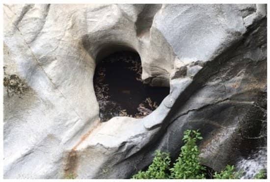
Heart Rock Formation
Beside the waterfall
A natural heart-shaped hole carved into a cliff, offering a unique photo opportunity.

Seeley Creek Waterfall
At the end of the trail
A beautiful 20-foot cascade that's most impressive after recent rains.

Scenic Creek-Side Trail
Along Seeley Creek
An enchanting 1.8-mile loop following a babbling creek through a wooded canyon.
Plans like a pro.
Thinks like you
Planning Your Visit
Timing is Key for Flowing Falls
Trail Navigation & Safety
Best Times
Insider Tips
from TikTok, Instagram & Reddit
🚗 Parking Advice
Park in the dirt patch near Camp Seeley. Google Maps is accurate, even if marked closed.
👟 Footwear Matters
Wear sturdy shoes for slippery rocks and inclines, especially near the waterfall.
💧 Water Levels Vary
Waterfall flow is best after rain. September visits may have no running water.
🐾 Dog-Friendly Trail
Well-behaved dogs are welcome on this scenic hike.
Tips
from all over the internet
🚗 Parking Advice
Park in the dirt patch near Camp Seeley. Google Maps is accurate, even if marked closed.
👟 Footwear Matters
Wear sturdy shoes for slippery rocks and inclines, especially near the waterfall.
💧 Water Levels Vary
Waterfall flow is best after rain. September visits may have no running water.
🐾 Dog-Friendly Trail
Well-behaved dogs are welcome on this scenic hike.
♻️ Leave No Trace
Pack out everything you pack in to preserve this natural gem.
What Travellers Say
Reviews Summary
Visitors praise Heart Rock Trail for its scenic beauty, following a creek to a unique heart-shaped rock and waterfall. It's considered a relaxing hike, though some find the path to the rock challenging and slippery. Water flow can be minimal outside of rainy seasons.
"It was a fairly easy hike with plenty of markings to guide you towards the heart. There wasn't any running water at this time of year (September), but it was still a fun hike. Once you see the paved pathway fork off into two paths, take the dirt path through the gate to the right instead of continuing on the paved path."
Scot Carrington
"Easy, fairly short trail, surrounded by trees, going alongside a creek. Now for relaxing and enjoying nature than for getting exercise. Highly recommend. One of the best trails in the area."
Hi Technique (Scythedelic)
"The trailhead is easy to find with Google Maps and despite saying it was closed on Google it was actually open. The hike begins on a paved path that eventually splits into a dirt trail or a continued paved route. Along the way, there are a few hills to climb, and to reach Heart Rock you’ll need to make your way down a hill, cross a small stream, and navigate over rocks and tree branches. We chose one of the easier routes, but there are multiple ways to get there. During our visit, we saw families, individuals, and several people with dogs enjoying the trail. While it’s a nice hike, I wouldn’t recommend it for small children, as parts of the trail run along the edge of a hillside and the downhill area can be tricky."
Tabitha Ortiz
What People Like
What People Dislike
Frequently Asked Questions
🚇 🗺️ Getting There
The trailhead is located near Camp Seeley in Crestline, California. Parking is available on a dirt patch on the side of the road. Google Maps is generally reliable for navigation, even if the trail is sometimes marked as closed.
Road conditions can vary. While some sources might indicate closures due to construction, many visitors report it being open. It's best to check recent local reports or be prepared for potential detours.
The trail follows Seeley Creek. There are multiple paths, including a paved route and a more challenging dirt path. Follow signs for Heart Rock. The dirt path requires more careful footing.
The parking area is a dirt patch, so while most cars can access it, it's not a paved lot. The road leading to the general area is part of the 'Rim of the World' scenic byway.
No, there are no restrooms available at the Heart Rock Trailhead. Be sure to plan accordingly before you arrive.
🎫 🎫 Tickets & Entry
No, Heart Rock Trail is a public access trail and does not require an entrance fee or ticket for hiking.
The trail is generally accessible during daylight hours. There are no official operating hours posted, but it's advisable to visit during safe daylight times.
There is no designated parking lot with a fee. Parking is available on the side of the road near Camp Seeley, and it is typically free.
Yes, dogs are welcome on the Heart Rock Trail, provided they are kept on a leash and you clean up after them.
The trail is generally open year-round, but conditions can change due to weather. Snow or heavy rain can make certain sections slippery or inaccessible.
🎫 🏞️ Onsite Experience
The loop trail is approximately 1.8 miles long, making it a relatively short and manageable hike for most visitors.+1
It's considered an easy to moderate hike. While parts are flat and follow a creek, there are some inclines and rocky sections, especially on the dirt path.
Comfortable hiking attire is recommended. Sturdy shoes with good grip are essential, particularly if you plan to explore near the waterfall or take the dirt path, as rocks can be slippery.
The paved path is more suitable for young children. The dirt path has steeper sections and can be tricky, and parts of the trail run along hillsides, so caution is advised.
Follow the signs for Heart Rock. The trail follows Seeley Creek. Look for a tree mentioned in some guides, then continue along the creek to find the waterfall and the heart-shaped formation.
📸 📸 Photography Tips
The Heart Rock formation itself is a prime photo spot. The waterfall and the scenic creek-side path also offer beautiful photographic opportunities.+1
Early mornings can offer softer light and fewer crowds, making for more serene photos. Midday sun can be harsh, but the waterfall can still be captured effectively.
A wide-angle lens is great for capturing the waterfall and the surrounding canyon. A polarizing filter can help manage reflections on wet rocks and water.
The heart-shaped hole in the rock is unique. You can also try capturing the motion of the waterfall with a longer exposure if you have a tripod.
Be prepared to navigate some slippery rocks to get close. Experiment with different angles to frame the heart shape effectively with the waterfall in the background.
For Different Travelers
Tailored advice for your travel style
👨👩👧 Families with Kids
Family-Friendly Tips:
* Choose the Paved Path: Opt for the easier route for little ones.
* Supervise Closely: Keep a watchful eye, especially near inclines and the creek.
* Pack Snacks & Water: The 1.8-mile hike can be tiring for kids.
* Consider Timing: Early mornings offer cooler temperatures and fewer crowds, making the experience more enjoyable for everyone.
🚶♀️ Solo Hikers & Nature Enthusiasts
Tips for Solo Adventurers:
* Inform Someone: Let a friend or family member know your hiking plans.
* Carry Essentials: Bring water, snacks, and a fully charged phone.
* Embrace the Quiet: Enjoy the solitude and the natural beauty.
* Be Aware of Conditions: Check recent trail reports for any unexpected closures or hazards.
Deep Dives
In-depth insights and expert knowledge
Understanding the Heart Rock Trail Experience
Visitors often describe the hike as more about relaxation and enjoying the scenery than intense exercise.
Key Takeaways for Your Visit:
* Trail Variety: Choose between a paved, easier path or a more adventurous dirt path.
* Slippery Conditions: Rocks near the waterfall and creek can be very slick.
* Water Flow: The waterfall is most impressive after recent rainfall; it may be dry in late summer or early fall.
* Leave No Trace: Help preserve the beauty by packing out all trash.
Navigating the Trail and Reaching the Heart
To reach the iconic Heart Rock, you'll need to follow the creek. Many visitors recommend continuing until you see a specific tree (often mentioned in online guides) and then following the riverbed for a short distance. This leads you to the waterfall and the heart-shaped formation.
Tips for Reaching Heart Rock:
* Follow the Creek: The sound of water is your guide.
* Scramble Carefully: The final approach requires navigating rocks.
* Consider the Paved Path: A safer option for families or those with mobility concerns.
* Look for Signs: While not always present, follow general trail markers.


Social
from TikTok, Instagram & Reddit