
Tai Mo Shan Hong Kong
Hong Kong's highest peak, offering breathtaking panoramic views and a refreshing escape into nature.
Highlights
Must-see attractions

Social
From TikTok & Reddit
Best Time
Best visibility for views
Tai Mo Shan Hong Kong
Best Time
Best visibility for views
Highlights
Must-see attractions
Hong Kong's highest peak, offering breathtaking panoramic views and a refreshing escape into nature.
"The highest point in Hong Kong with incredible views, easily accessible for a memorable day out."

👟 Wear comfortable shoes
Sturdy hiking boots or trail runners are best for the varied terrain.
🚌 Public transport is easy
Take a bus to Tsuen Wan, then a minibus to the campsite.

Quick Facts
Rating
4.4 · 476 reviews
Type
Mountain Peak
Address
Highlights
Discover the most iconic attractions and experiences
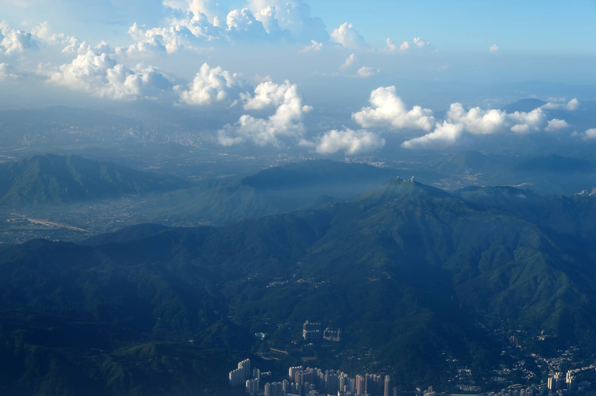
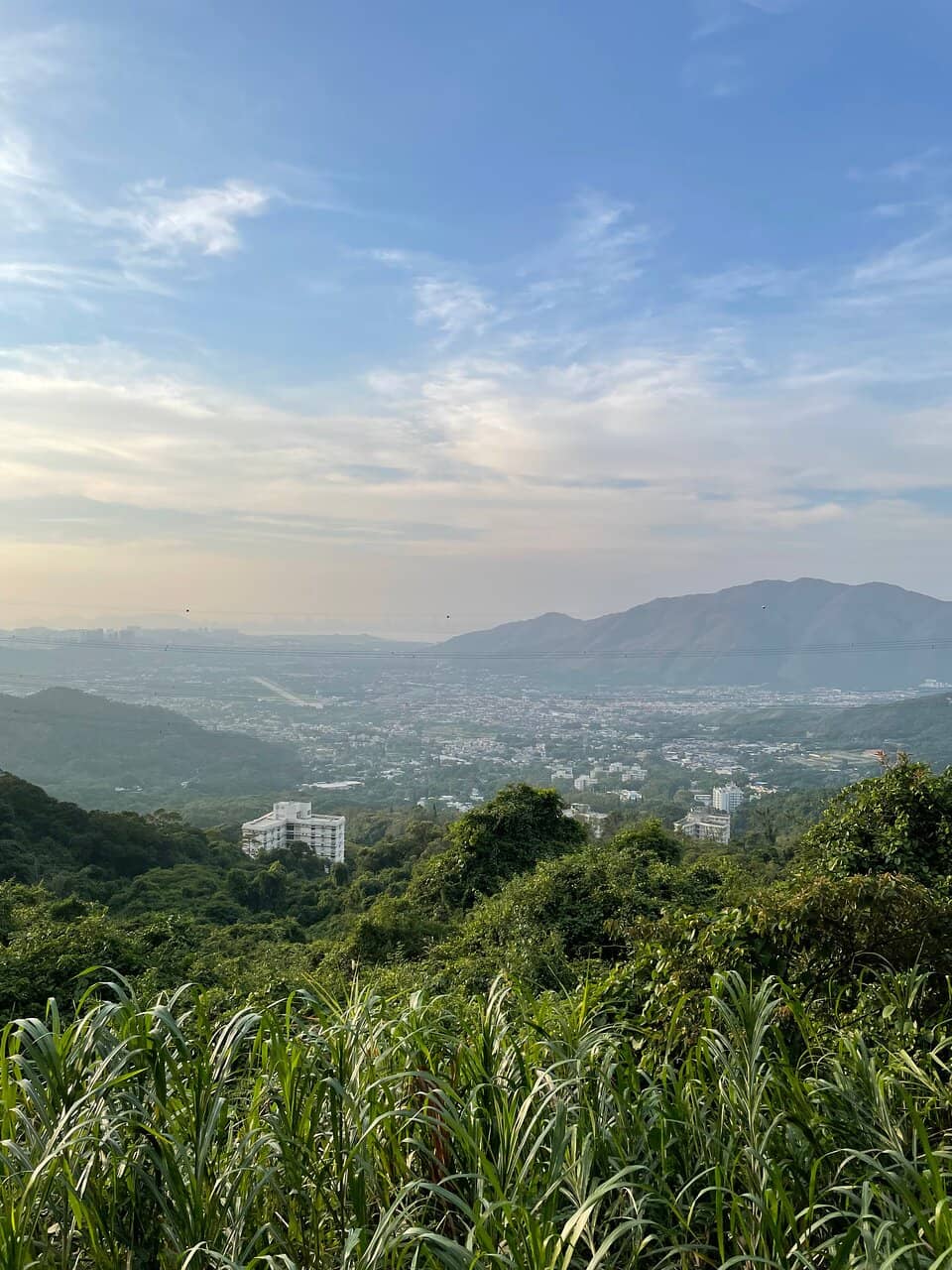
Tai Mo Shan Summit
Peak
Hong Kong's highest point offers panoramic views of the city and surrounding countryside. A must-see for any visitor.
Tai Mo Shan Country Park Visitor Centre
Base of the mountain
Learn about the park's ecology and history. A great starting point for your adventure.

Radar Station
Summit area
An iconic landmark at the peak, offering a unique photo opportunity.
Plans like a pro.
Thinks like you
Planning Your Visit
Best Footwear for the Summit
Getting to Tai Mo Shan
Best Times
Insider Tips
from TikTok, Instagram & Reddit
👟 Wear comfortable shoes
Sturdy hiking boots or trail runners are best for the varied terrain.
🚌 Public transport is easy
Take a bus to Tsuen Wan, then a minibus to the campsite.
💧 Bring water and snacks
Limited facilities on the trails, so pack essentials.
☁️ Check the weather
Fog can obscure views, especially in cooler months.
Tips
from all over the internet
👟 Wear comfortable shoes
Sturdy hiking boots or trail runners are best for the varied terrain.
🚌 Public transport is easy
Take a bus to Tsuen Wan, then a minibus to the campsite.
💧 Bring water and snacks
Limited facilities on the trails, so pack essentials.
☁️ Check the weather
Fog can obscure views, especially in cooler months.
What Travellers Say
Reviews Summary
Visitors praise Tai Mo Shan for its stunning panoramic views and accessibility as Hong Kong's highest point. Many appreciate the ease of reaching the summit via a paved road and the natural beauty of the country park. However, some note that fog can significantly impact visibility, and facilities can be basic.
"Sadly have to give it a 4 stars as the summit is very underwhelming. Note that we can’t go into the observatory so the summit is actually just the gate to the observatory. No sign or whatever. The best views are when you are hiking up and down the mountain. Take bus 51 from Tsuen Wan or TW west to the country park. Elevation wise, only 500m if you hike from the bus stop. There are many steps at the start but at the end it’s just road."
Seah Jia Hui
"Love this route from Chuen Lung. We have been on it a couple of times. The views on the way up Tai Mo Shan and up there were phenomenal. Tai Mo Shan is obviously a popular hiking spot. We found quite a few hikers on the top every time we got up there on weekdays. Public transportation available from Tsuen Wan to Route Twist makes visiting Tai Mo Shan Peak easier☺️."
Val
"Its name is well deserved, Tai Mo Shan (foggy mountain). It rained a bit the day I went there, oh boy it sure was foggy. I’m not complaining cuz it’s an interesting experience, I doubt you can get this view anywhere else in Hong Kong. Pick a sunny day to go if you want a clear view.
Although it’s the highest point in HK, the road up there is not difficult. Saw many kids and cyclists too, I think it’s suitable for beginner. Beware of vehicles tho, a lot of people drive there.
Also quite pleasant to see some yellow and black cows just there chilling, eating grass. They seemed to keep walking upward, I wonder where their destination was. The peak maybe? I stopped at the facility with a hemispherical building, I don’t know if that’s the peak. Also have fun avoiding all the cow poop sitting on the road.
Would like to revisit on a beautiful day in Autumn."
Andd Gaym
What People Like
What People Dislike
Frequently Asked Questions
🚇 🗺️ Getting There
You can take a bus to Tsuen Wan and then catch a minibus (e.g., Route 32) that goes towards the Tai Mo Shan Country Park Visitor Centre or campsite. From there, you can hike up to the summit.
Yes, it's quite straightforward. Buses and minibuses connect major areas to the base of the mountain, making it accessible for those who don't drive.
Yes, there is a road that leads to the summit. Parking is available, but it can fill up quickly on weekends and holidays.
You can start from Shing Mun, Lead Mine Pass, or directly from the Tai Mo Shan Country Park Visitor Centre. Each offers a different experience and difficulty level.
Yes, public transport signage is often in English, and drivers are generally accustomed to tourists.
🎫 🎫 Tickets & Entry
No, Tai Mo Shan Country Park is free to enter. There are no admission fees for the park itself.
The country park is generally open 24/7. The Visitor Centre has specific operating hours, which you should check before your visit.
There is no entrance fee to reach the summit of Tai Mo Shan. Access to the peak is free.
No booking is required for general access. If you plan to camp in designated areas, you might need to check for reservation requirements.
Generally, there are no major restrictions, but always be mindful of park rules, especially regarding littering and safety.
🎫 🚶 Onsite Experience
You can hike to the summit for panoramic views, explore the country park trails, visit the Visitor Centre, and see the iconic radar station.
The time varies depending on your starting point and pace. From the Visitor Centre, it can take about 1-2 hours to reach the summit via the paved road.
Restrooms are available at the Visitor Centre and at some designated picnic spots along the main road.
Yes, the paved road to the summit is manageable for families, though younger children might need assistance. The Visitor Centre also offers educational exhibits.
On a clear day, you'll get breathtaking 360-degree views of Hong Kong's urban landscape, the New Territories, and even mainland China.
📸 📸 Photography
The summit with the radar station, panoramic viewpoints along the road, and the surrounding natural landscapes offer great photo opportunities.
Early morning for soft light and fewer crowds, or late afternoon for golden hour. Be aware of potential fog.
Drone usage may be restricted, especially near the radar station. Always check local regulations before flying.
A wide-angle lens is great for landscapes, and a telephoto lens can capture distant cityscapes. A tripod can be useful for low-light conditions.
The juxtaposition of the modern radar station against the natural landscape, and the vast urban sprawl below, make for unique shots.
You may also like
Bride's Pool Hong Kong

Ng Tung Chai Waterfalls Hong Kong

Castle Peak Hong Kong

Shing Mun Reservoir Hong Kong

Tsing Yi Promenade Hong Kong

Kadoorie Farm and Botanic Garden Hong Kong
Bride's Pool Hong Kong
Ng Tung Chai Waterfalls Hong Kong
Castle Peak Hong Kong
Shing Mun Reservoir Hong Kong
Tsing Yi Promenade Hong Kong
Kadoorie Farm and Botanic Garden Hong Kong

Ten Thousand Buddhas Monastery Hong Kong
Stanley Ma Hang Park Hong Kong

Tai Po Market (Old Town) Hong Kong

Social
from TikTok, Instagram & Reddit