
Surenenpass Trail
A challenging high mountain pass hike in the Uri Alps, offering breathtaking views and alpine meadows.
Highlights
Must-see attractions

Social
From TikTok & Reddit
Best Time
Snow-free trails, vibrant wildflowers
Surenenpass Trail
Best Time
Snow-free trails, vibrant wildflowers
Highlights
Must-see attractions
A challenging high mountain pass hike in the Uri Alps, offering breathtaking views and alpine meadows.
"One of the nicer hikes this side of the Alps, with beautiful flowers and views."
Check Snow Conditions
Snow can persist until late May/early June. Always check recent reports before heading out! :snowflake:
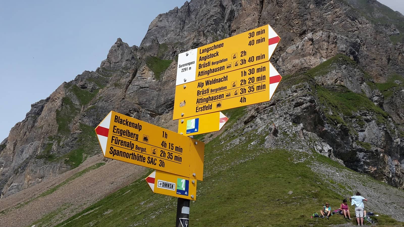
Cable Car Shortcut
Use the Brüsti cable car to reduce ascent and save energy for the descent. 🚡
Quick Facts
Rating
4.9 · 27 reviews
Type
Natural Feature
Highlights
Discover the most iconic attractions and experiences
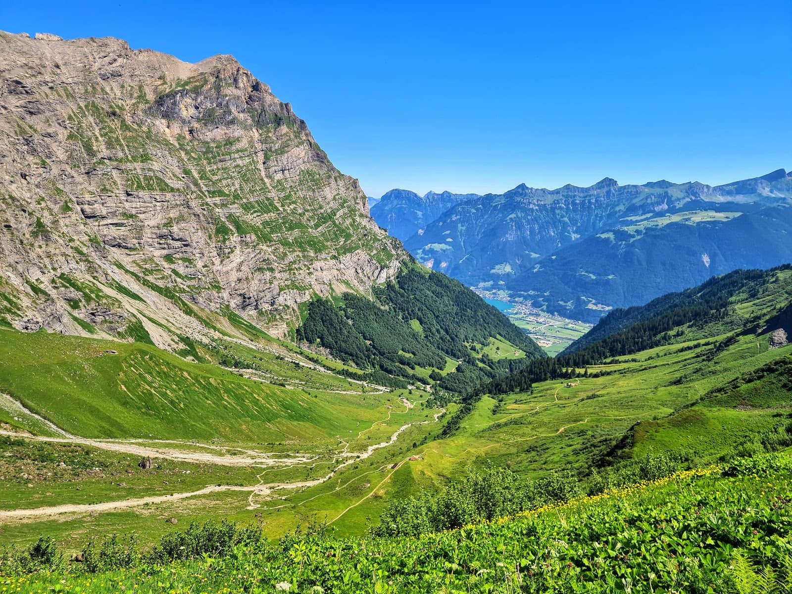
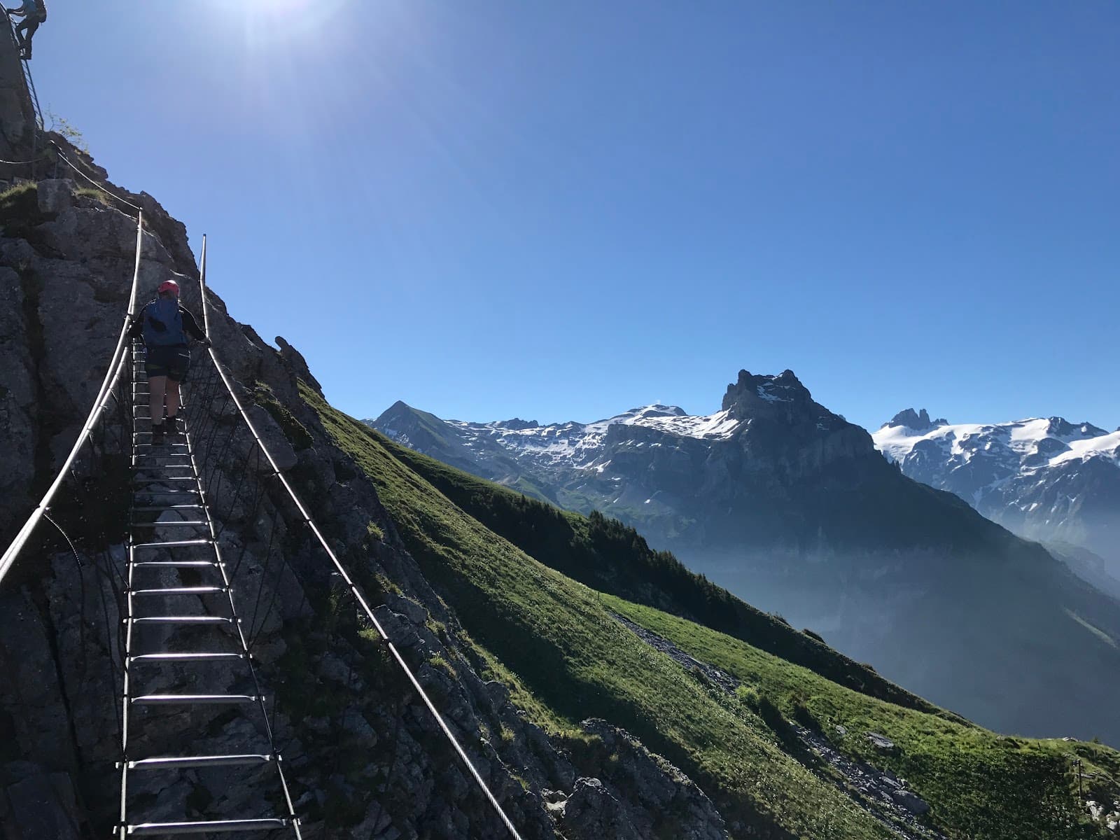
Surenen Pass Summit
Uri Alps
Experience breathtaking panoramic views of the Swiss Alps, including Mount Titlis.
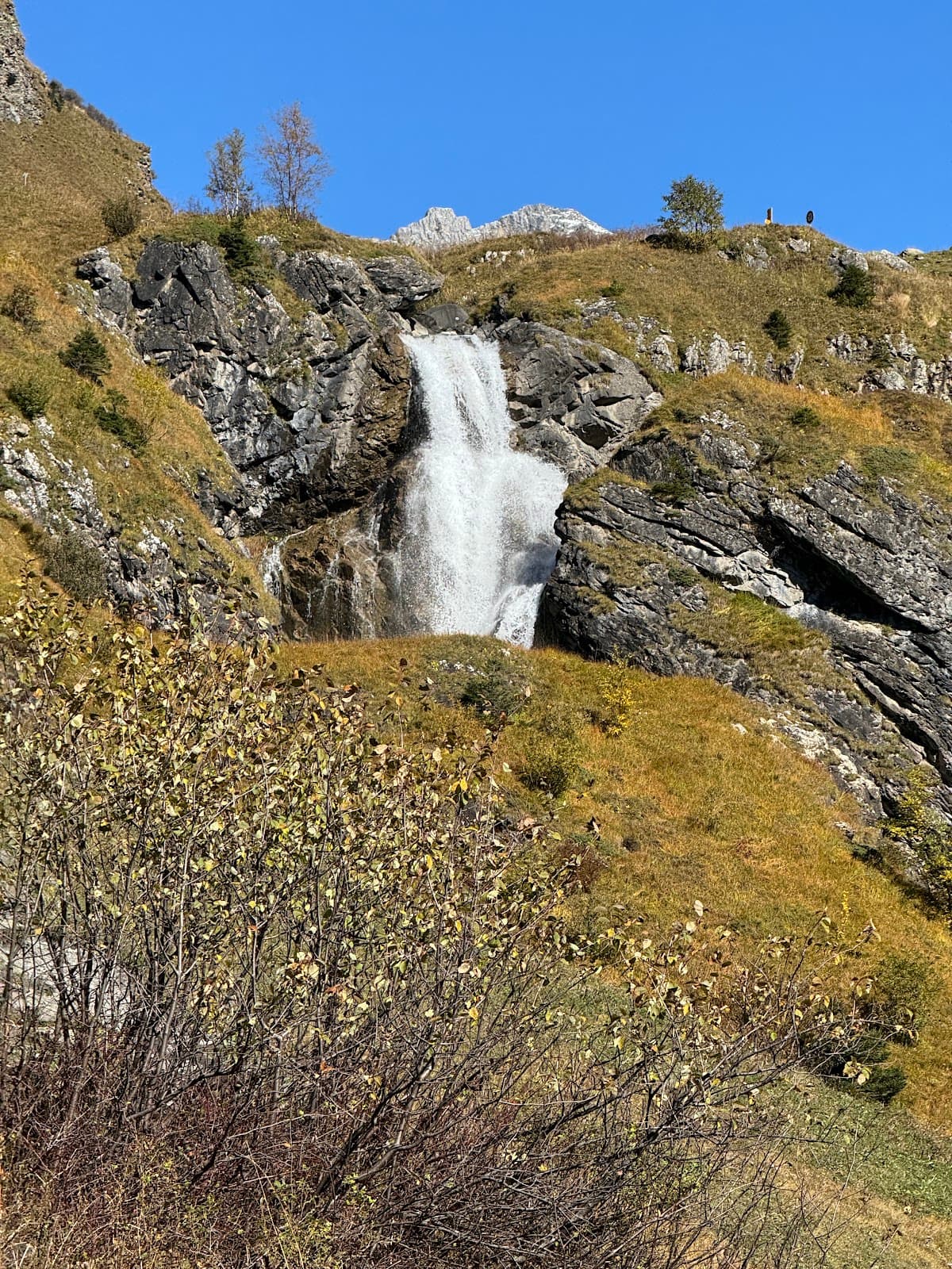
Alpine Meadows
Upper sections of the trail
Hike through stunning terrain adorned with beautiful wildflowers in season.
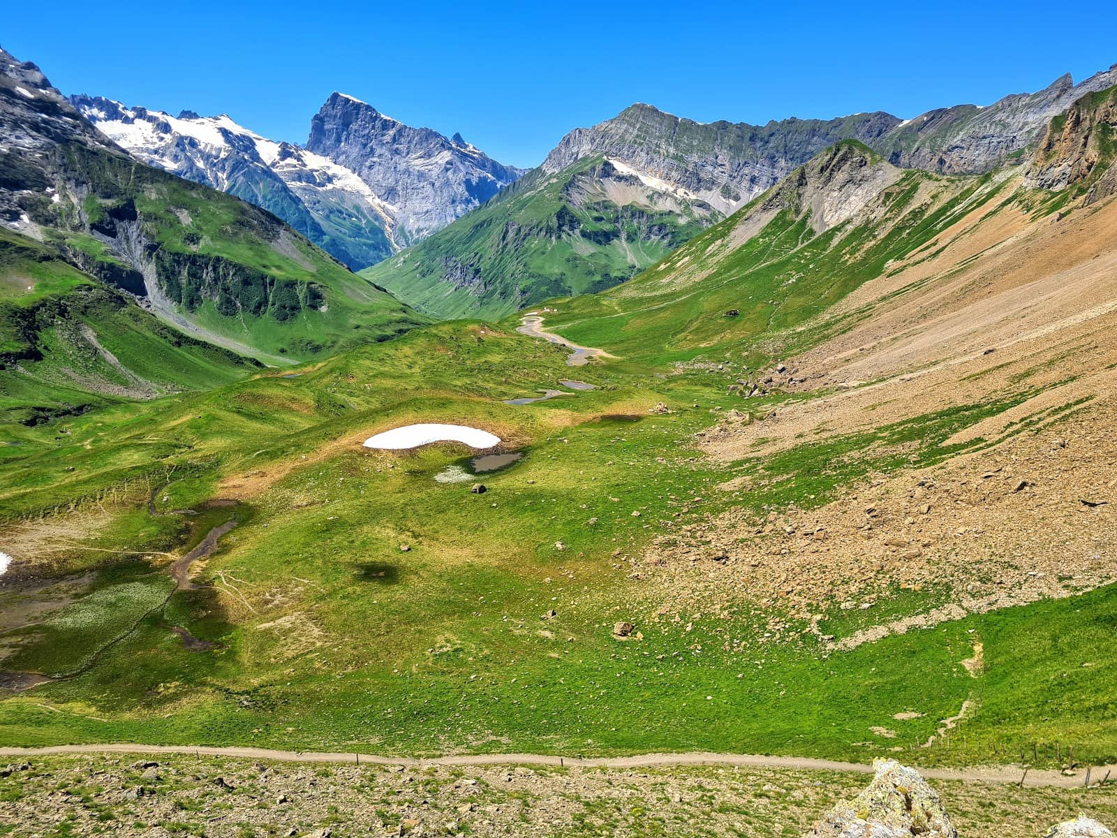
Descent to Engelberg
From Surenen Pass to Engelberg
A memorable trail with varied landscapes, offering a rewarding end to your hike.
Plans like a pro.
Thinks like you
Planning Your Visit
Timing is Everything
Route & Logistics
Best Times
Insider Tips
from TikTok, Instagram & Reddit
Check Snow Conditions
Snow can persist until late May/early June. Always check recent reports before heading out! :snowflake:
Cable Car Shortcut
Use the Brüsti cable car to reduce ascent and save energy for the descent. 🚡
Hydration is Key
It's a long hike! Carry plenty of water and snacks, though food is available at Blackenalp. :water_wave:
Sturdy Footwear Needed
The terrain can be challenging. Wear good hiking boots for comfort and safety. :athletic_shoe:
Tips
from all over the internet
Check Snow Conditions
Snow can persist until late May/early June. Always check recent reports before heading out! :snowflake:
Cable Car Shortcut
Use the Brüsti cable car to reduce ascent and save energy for the descent. 🚡
Hydration is Key
It's a long hike! Carry plenty of water and snacks, though food is available at Blackenalp. :water_wave:
Sturdy Footwear Needed
The terrain can be challenging. Wear good hiking boots for comfort and safety. :athletic_shoe:
Capture the Views
The scenery is incredible! Don't forget your camera or phone for stunning alpine shots. :camerawithflash:
What Travellers Say
Reviews Summary
The Surenenpass Trail is lauded for its stunning alpine scenery and challenging, memorable hiking experience. Visitors praise the beautiful flowers and panoramic views, particularly of Mount Titlis. However, hikers should be aware of the trail's length and potential for snow and avalanche risks early in the season, with some finding the descent demanding.
"Still 50-60cm of snow 25.05.2025"
C. J.
"Great hike beautiful flowers and views"
david nevill
"One of them nicer hikes this side of the alps."
Marcel Ziswiler
What People Like
What People Dislike
Frequently Asked Questions
🚇 🗺️ Getting There
Most hikers start from Altdorf and take a bus to the Brüsti cable car valley station. From Brüstialp, the trail begins. Alternatively, you can start from Attinghausen for a longer route. The trail can also be accessed from Engelberg.
Yes, public transport is well-integrated. Buses connect to cable car stations, making it easy to access different starting and ending points of the trail. 🚌 🚂
Yes, you can hike up to the Surenen Pass from Engelberg, or use the Brüsti cable car to start higher up and descend towards Engelberg.
From Altdorf, take a bus directly to the Brüsti cable car valley station. This is a common starting point for the Surenenpass hike.
Parking is generally available near cable car stations or in towns like Altdorf and Engelberg, but it's advisable to check specific locations and fees beforehand.
🎫 🎫 Tickets & Entry
The trail itself is free to access. However, you will need to purchase tickets for the Brüsti cable car if you choose to use it. 🎟️
Operating hours for the Brüsti cable car vary seasonally. It's best to check their official website for the most up-to-date schedule before your visit.
No, there are no specific entrance fees for the Surenenpass area itself, as it's part of the natural landscape and hiking routes.
While not always necessary, booking cable car tickets in advance can sometimes save time, especially during peak season. Check the cable car operator's website for options.
No, the Surenenpass Trail is typically only accessible and safe during the summer months due to snow and avalanche risks in winter and spring.
🎫 🥾 Onsite Experience
The Surenenpass hike is considered a challenging, long-distance trail. It involves significant elevation gain and loss, requiring good physical fitness.
A full hike from Altdorf to Engelberg can take anywhere from 8-10 hours, depending on your pace and stops. Using the Brüsti cable car can shorten this time.
Expect stunning alpine landscapes, including dramatic mountain peaks, lush meadows, and potentially snowfields early in the season. The views of Mount Titlis are a highlight.
Yes, there are typically mountain huts or restaurants available, such as at Blackenalp and Fürenalp, where you can get food and refreshments.
Pack essentials like sturdy hiking boots, layers of clothing, rain gear, plenty of water, snacks, sunscreen, a map, and a first-aid kit. 🎒
📸 📸 Photography
The summit of the Surenen Pass offers panoramic views, especially towards Mount Titlis. The alpine meadows with wildflowers are also incredibly photogenic.
Early morning and late afternoon offer the best light for landscape photography, with softer shadows and warmer tones. Sunrise and sunset can be spectacular if you're staying overnight.
A wide-angle lens is great for capturing the expansive mountain vistas. A telephoto lens can be useful for isolating distant peaks. Don't forget a sturdy tripod if you plan on long exposures or low-light shots.
The pass itself is a prime spot. Look for elevated points along the trail that offer unobstructed views of the surrounding peaks and valleys. The descent towards Engelberg also provides unique perspectives.
Drone regulations can vary in Switzerland. It's crucial to check local rules and obtain any necessary permits before flying a drone in the area to avoid fines.


Social
from TikTok, Instagram & Reddit