Taegisan
Hike beneath colossal wind turbines to a summit observatory for breathtaking sunrises and panoramic mountain views.
Highlights
Must-see attractions

Social
From TikTok & Reddit
Best Time
For spectacular sunrises
Taegisan
Best Time
For spectacular sunrises
Highlights
Must-see attractions
Hike beneath colossal wind turbines to a summit observatory for breathtaking sunrises and panoramic mountain views.
"Witness the power of nature and enjoy stunning sunrises amidst giant wind turbines."
👟 Essential Footwear
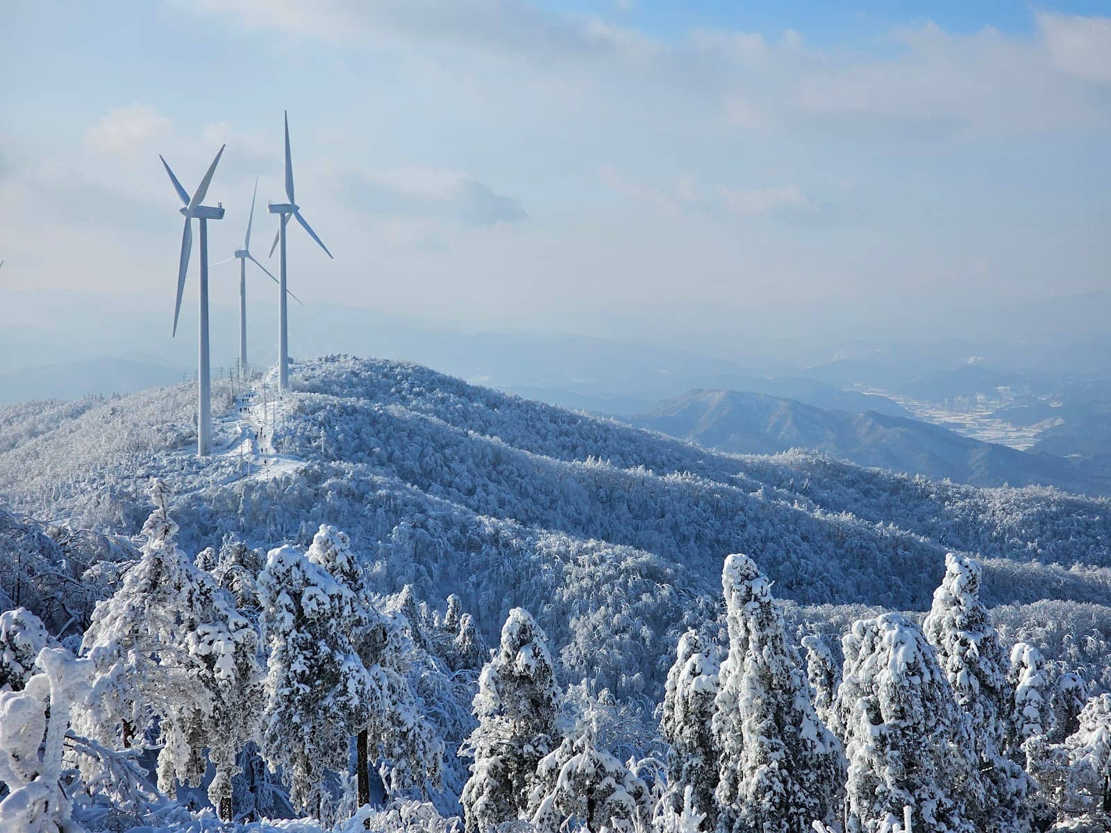
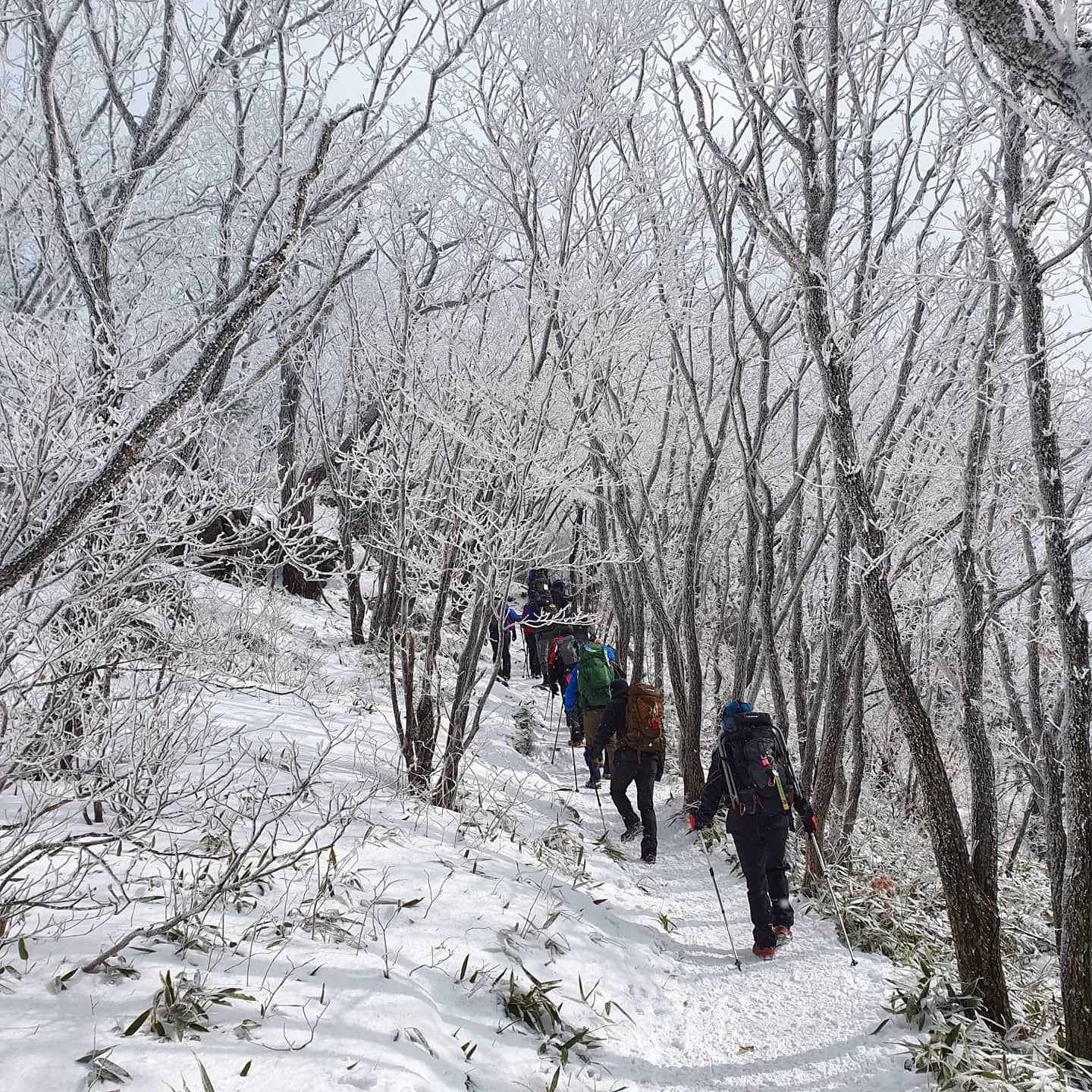
Crampons are a must in winter due to ice. The forest road can be steep and slippery year-round.
🎒 Pack Out Trash
Leave no trace. Bring a trash bag and take all your waste with you to keep Taegisan pristine.
Quick Facts
Rating
4.2 · 45 reviews
Type
Natural Feature
Highlights
Discover the most iconic attractions and experiences
Taegisan Summit Observatory
Summit
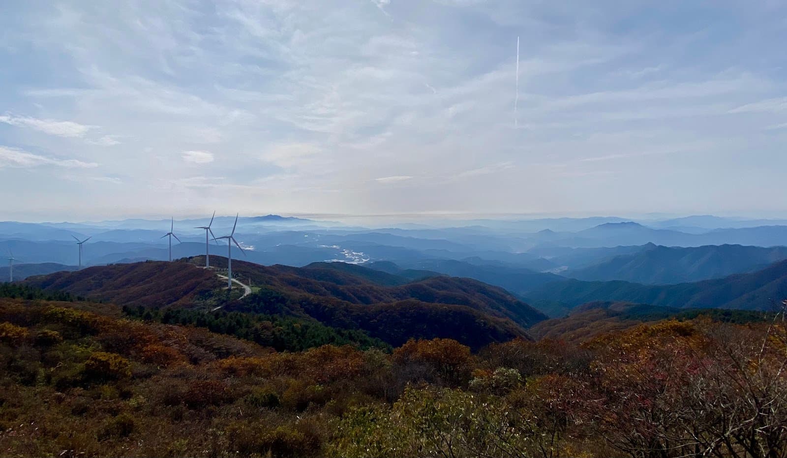
Panoramic views stretching to Chiaksan Mountain on clear days. A rewarding sight after your trek.
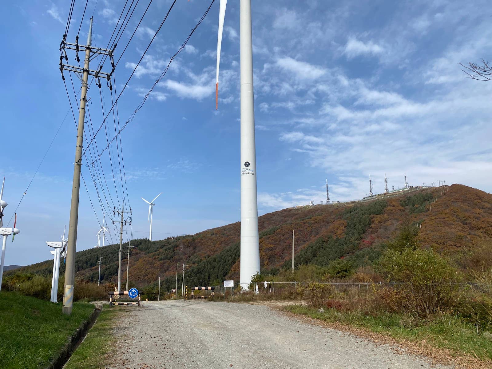
Wind Turbine Trail
Forest road
Walk beneath colossal wind turbines for a unique, awe-inspiring perspective. Feel the power of nature.
Sunrise Views
Summit
Witness breathtaking sunrises that make the early morning trek worthwhile. A truly magical experience.
Plans like a pro.
Thinks like you
Planning Your Visit
Timing Your Sunrise Hike
Respecting Nature and Regulations
Best Times
Insider Tips
from TikTok, Instagram & Reddit
👟 Essential Footwear
Crampons are a must in winter due to ice. The forest road can be steep and slippery year-round.
🎒 Pack Out Trash
Leave no trace. Bring a trash bag and take all your waste with you to keep Taegisan pristine.
⬆️ Summit Access
The actual summit stone is slightly below the military facility. The observatory offers the best views.
🚗 Road Conditions
The road to the summit was rough and could be nerve-wracking. Check current access before driving.
Tips
from all over the internet
👟 Essential Footwear
Crampons are a must in winter due to ice. The forest road can be steep and slippery year-round.
🎒 Pack Out Trash
Leave no trace. Bring a trash bag and take all your waste with you to keep Taegisan pristine.
⬆️ Summit Access
The actual summit stone is slightly below the military facility. The observatory offers the best views.
🚗 Road Conditions
The road to the summit was rough and could be nerve-wracking. Check current access before driving.
🌬️ Brace for Wind
Strong winds are common, especially near the wind turbines. Dress in layers for protection.
What Travellers Say
Reviews Summary
Visitors praise Taegisan for its breathtaking sunrise views and the unique spectacle of walking among massive wind turbines. The panoramic vistas from the summit observatory are a major highlight. However, some note the challenging, steep terrain, especially in winter, and express concern over litter left by some visitors, urging for greater environmental respect.
"When I lived in Gyeonggi-do...
I used to go there when I was bored in the early morning...
Looking back, Gyeonggi-do seems like a really good place for people who like mountains...ㅎㅎ
There are mountains all around...and if you go for a couple of hours, you can easily access Gangwon-do..
I used to be able to drive up to the military base at the top of Taegisan Mountain by car, but I guess I can't do that anymore.
Even when I could drive up, the road was rough, so I was nervous that my tires would burst...ㅎㅎㅎ
I remember going there three or four times and finally seeing the sunrise that I liked once and feeling so proud(?)..
There are a lot of people who camp here too...
It would be good to stay a little more cleanly...but because of a few people, camping seems to be getting harder and harder...
Seonjaryeong / Yukbaekmajigi / Anbandegi / Taegisan...it's a shame that many people are restricted because of the ignorance of a few people.
When going to the mountain, shouldn't you take your own trash bag with you? Hahahahaha
I hope you stay neat and tidy as you are.......
Please!!!!"
신정명
"It was a pity that I couldn't see the snow flowers because there wasn't much snow. I think it's more like a forest road walk than a hike. I should go right after it snows or while it's snowing."
Donghee Kim (Dominick)
"The shortest round trip from the Yangdugumijae trailhead to the summit is listed as 5km, but in reality, it's around 9-10km.
Because there's a military facility at the summit of Taegisan Mountain, the actual summit stone is about 100m below the summit. There's an observatory next to the stone, and on clear days, you can see as far as Birobong Peak (the highest peak of Chiaksan Mountain) in the distance.
At the Yangdugumijae trailhead, there's parking on both sides of the mountain pass. Park there and walk up the hill, following the wind turbines behind the barricades. The initial slope of the forest road is quite steep. Once the ground appears flat, the trail begins to descend. A long forest road connects the Taegisan summit stone and the summit beyond, making it a trekking path except in the dead of winter when snow covers the ground.
In the dead of winter, the winds are quite strong (as you might guess from the presence of the wind turbines). Even a small amount of snow can cause ice and slippery conditions, so crampons are essential. Recently, there are people who go downhill with sleds... I wonder how they will stop... It's a good course to walk along the forest road with a steep slope even in spring and fall."
Reno Park
What People Like
What People Dislike
Frequently Asked Questions
🚇 🗺️ Getting There
Taegisan is accessible by car, with trailheads like Yangdugumijae offering parking. Some visitors recall driving close to the summit, but road conditions can be rough and access may vary. Public transport options might be limited, so checking local transit schedules is advised.
Yes, parking is available at trailheads such as Yangdugumijae, located on both sides of the mountain pass.
Historically, it was possible to drive to a military base near the summit, but the road was rough. Current access for vehicles to the very top may be restricted or challenging.
Driving is generally the most convenient way to reach the Yangdugumijae trailhead. If using public transport, research bus routes to nearby towns and then consider a taxi to the trailhead.
The Yangdugumijae trailhead is a primary access point for hiking Taegisan, offering a route to the summit.
🎫 🎫 Tickets & Entry
Taegisan is a natural mountain area, and typically does not require an entrance fee. However, always check for any local park regulations or potential fees that might be in place.
As a natural park, Taegisan is generally accessible at all times. However, for sunrise hikes, ensure you are comfortable hiking in the dark and are aware of any safety considerations.
Parking at trailheads like Yangdugumijae is usually free, but it's advisable to confirm this upon arrival as regulations can change.
Camping regulations can be strict due to environmental concerns. It's crucial to research and obtain any necessary permits for camping in advance.
Taegisan is open year-round. Visiting on holidays might mean more crowds, especially if it's a popular local spot for celebrations or events.
🎫 🧭 Onsite Experience
The shortest round trip from Yangdugumijae is about 9-10km, indicating a moderate to challenging hike. The initial forest road is steep, and winter conditions can make it very slippery.
Dress in layers, as winds can be strong. In winter, waterproof and windproof gear is essential, along with sturdy boots and crampons.
Restroom facilities might be limited, especially at higher elevations or remote trailheads. It's best to use facilities at the base before starting your hike.
The steepness and potential winter hazards might make it challenging for very young children. Consider the season and your children's hiking experience. The forest road walk could be more manageable.
Expect expansive views from the summit observatory, including distant peaks like Birobong Peak on clear days. The trail also offers close-up views of large wind turbines.
📸 📸 Photography
The summit observatory provides panoramic vistas, especially during sunrise. The wind turbines themselves are also striking photographic subjects, offering unique perspectives.
Early morning for sunrise is highly recommended for dramatic lighting. Golden hour in the late afternoon can also offer beautiful light.
A wide-angle lens is great for capturing the expansive landscapes and wind turbines. A tripod can be useful for sunrise shots in low light.
Yes, the trail passes directly beneath the wind turbines, allowing for impressive close-up shots of these massive structures.
While generally permitted, be mindful of any military facilities near the summit and avoid photographing sensitive areas.


Social
from TikTok, Instagram & Reddit