Canso Plane Crash Site
Explore the haunting Canso Plane Crash Site, a WWII bomber wreckage nestled in Tofino's rainforest. A muddy but memorable historical adventure.
Highlights
Must-see attractions

Social
From TikTok & Reddit
Best Time
Drier trails, less mud
Canso Plane Crash Site
Best Time
Drier trails, less mud
Highlights
Must-see attractions
Explore the haunting Canso Plane Crash Site, a WWII bomber wreckage nestled in Tofino's rainforest. A muddy but memorable historical adventure.
"Worth the hike to see some real history. "
👟 Wear Waterproof Boots
Mud is inevitable! Sturdy, waterproof boots are essential for this hike.
📍 Park at Radar Hill
The Radar Hill parking lot is a convenient starting point for the hike.
Highlights
Discover the most iconic attractions and experiences
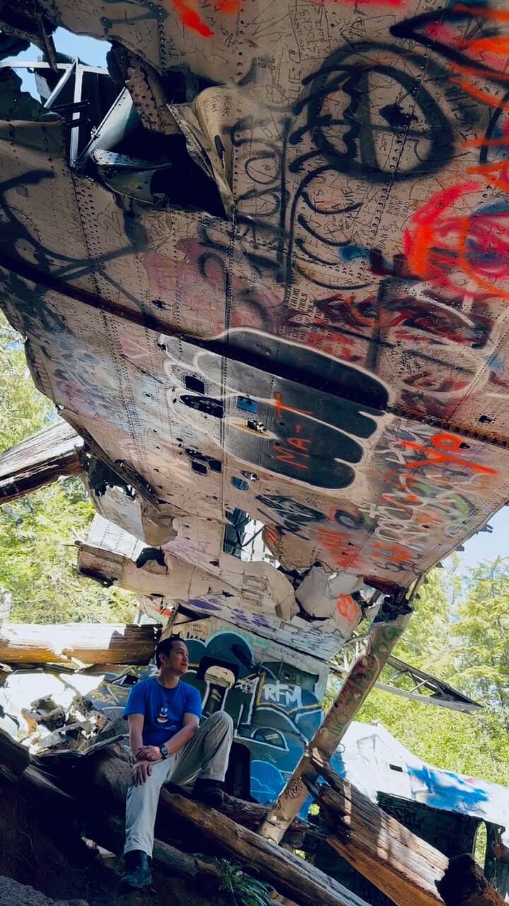
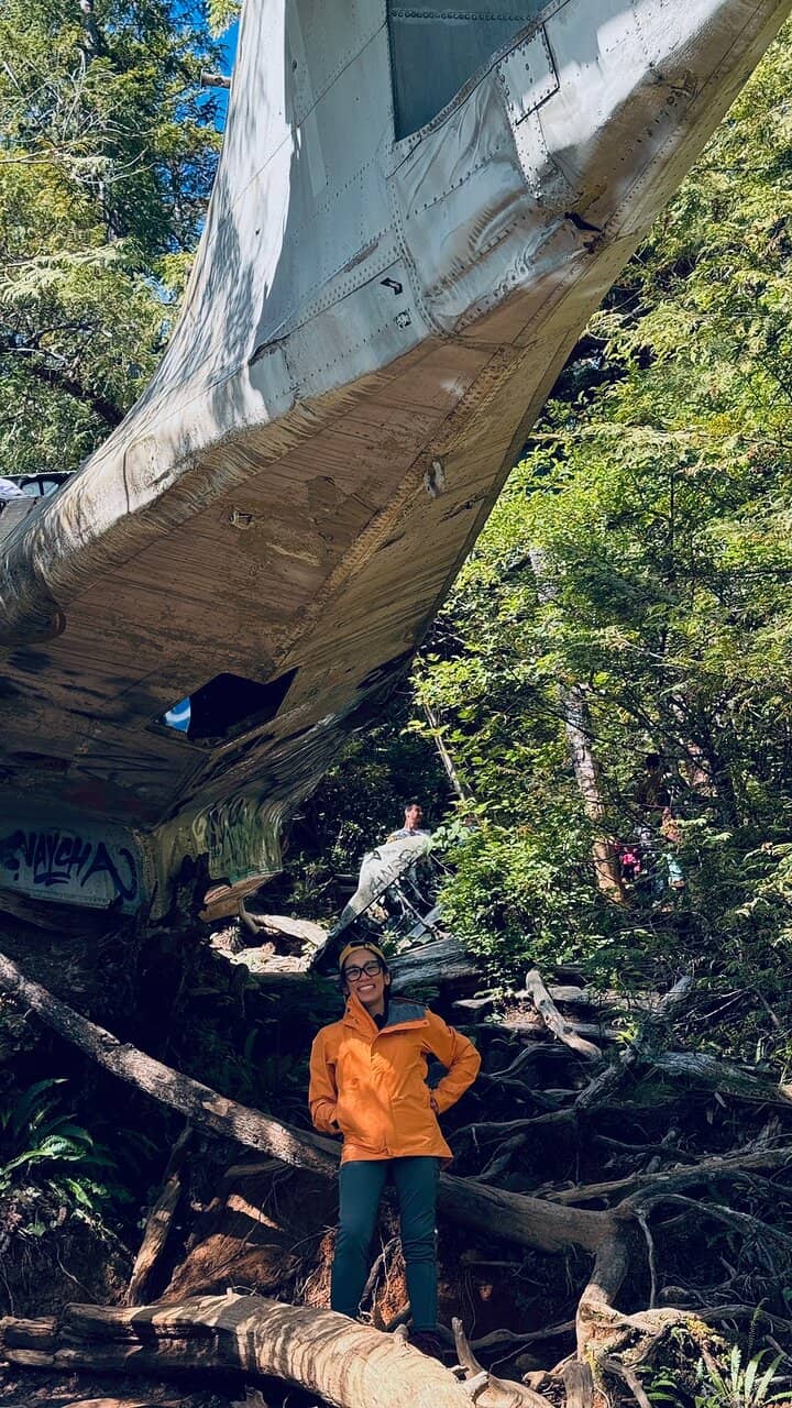
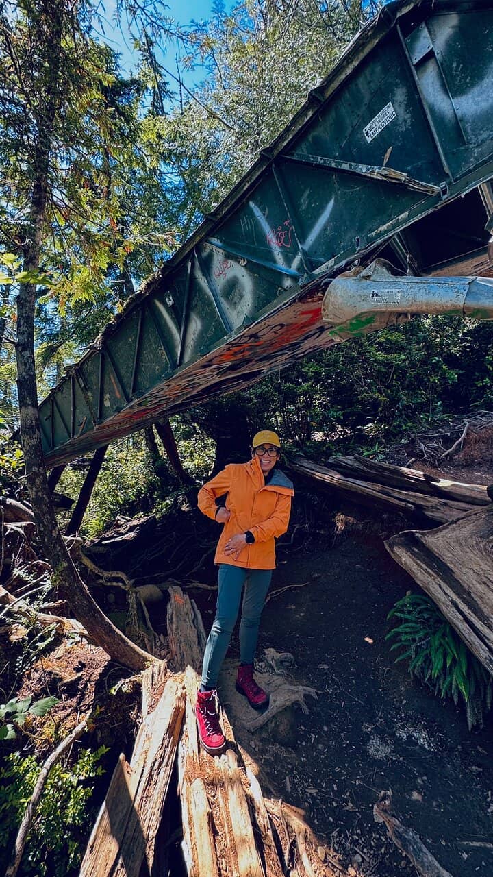
WWII Canso Bomber Wreckage
End of the trail
Explore the hauntingly preserved wreckage of a Canso bomber that crashed in 1945. A tangible piece of history.
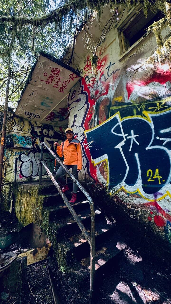
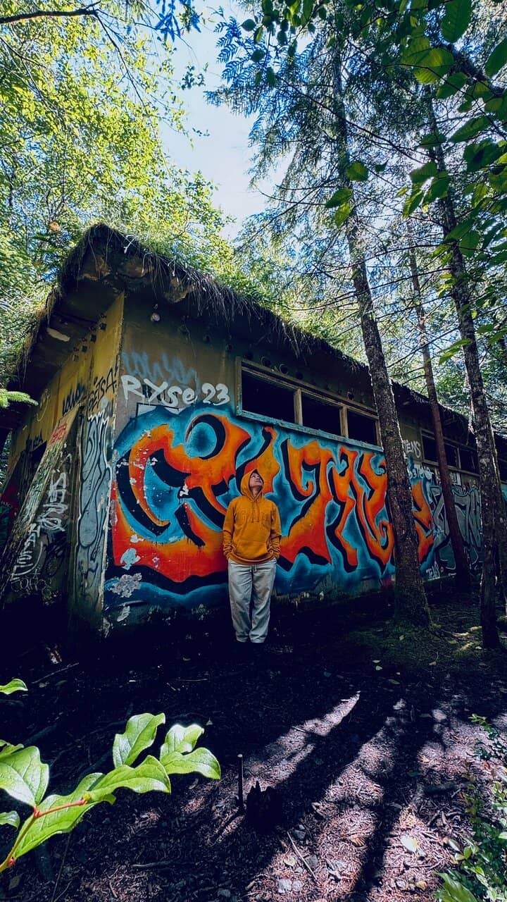
Historic Bunker
Along the trail
Discover an abandoned bunker, a fascinating relic from the past, often adorned with graffiti.
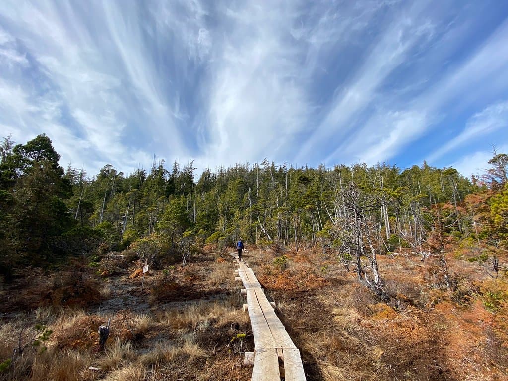
Rainforest Boardwalks
Trail sections
Navigate muddy sections on well-placed boardwalks, offering a unique hiking experience through the coastal rainforest.
Plans like a pro.
Thinks like you
Planning Your Visit
Embrace the Mud!
Timing is Key for History
Best Times
Insider Tips
from TikTok, Instagram & Reddit
👟 Wear Waterproof Boots
Mud is inevitable! Sturdy, waterproof boots are essential for this hike. +1
📍 Park at Radar Hill
The Radar Hill parking lot is a convenient starting point for the hike.
🗺️ Follow Trail Markers
The trail is generally well-marked, with boardwalks guiding you through tricky spots.
⏳ Allow 1.5-2 Hours
The out-and-back hike is about 4km and takes roughly 1.5-2 hours roundtrip.
Tips
from all over the internet
👟 Wear Waterproof Boots
Mud is inevitable! Sturdy, waterproof boots are essential for this hike. +1
📍 Park at Radar Hill
The Radar Hill parking lot is a convenient starting point for the hike.
🗺️ Follow Trail Markers
The trail is generally well-marked, with boardwalks guiding you through tricky spots.
⏳ Allow 1.5-2 Hours
The out-and-back hike is about 4km and takes roughly 1.5-2 hours roundtrip.
💧 Be Prepared for Mud
Even in summer, expect muddy sections. Embrace the mess!
What Travellers Say
Reviews Summary
Visitors find the Canso Plane Crash Site a fascinating and worthwhile historical exploration, despite the challenging muddy conditions. The well-placed boardwalks help navigate the terrain, and the preserved wreckage offers a unique glimpse into the past. Some note graffiti on the bunker, but the overall experience is considered a memorable adventure.
"So cool to see something like that. Worth the hike to see some real history. Unfortunately, there is a lot of graffiti but the metal is twisted but in good shape. The beginning of the trail is easy but get harder and muddier. Lots of trail markers and planks over some rough spots. Well worth the hike but plan for over a hour."
Dave Chao
"Despite reading mixed reviews, we were excited to take on this trek and see the famous plane crash site. We parked at the Radar Hill lot right off the highway, which was convenient. The trail starts off well-maintained and easy to follow, especially up to the historic bunker — an interesting stop in itself.
Beyond the bunker, the trail gets rougher. The next 15-minute descent isn’t well-maintained, and it can get quite muddy — even in the summer. (We did the trek in the second week of May, and it was still messy!) Expect lots of exposed roots, high steps, and slippery sections that can dirty your shoes quickly.
Thankfully, the community has done a fantastic job installing wooden planks over the boggy areas. Without them, this section would’ve been nearly impassable. The planks guide you all the way to the crash site, which is a fascinating and moving piece of history.
If you’re willing to get a little dirty, it’s absolutely worth it. Embrace the mess — it’s part of the adventure!"
Japteg Singh
"Very cool site to explore. The abandoned building at the mouth of the trail is cool for exploring and photos! The hike is muddy when wet and about 30-40 mins to the crash site from the road but not a very technical trail. Bring shoes with good tread. Lots of walking on a boardwalk-like path which can get a bit slick."
Hnc Subcontractors
What People Like
What People Dislike
Frequently Asked Questions
🚇 🗺️ Getting There
The most common starting point is the Radar Hill parking lot near Tofino. From there, walk south on the bike road and take a right at the first 4-way intersection onto a narrow trail. Follow this trail for about 30-40 minutes to reach the crash site.
Yes, there is a designated parking lot at Radar Hill, which is a convenient starting point for the hike.
Public transport options to the Radar Hill area are limited. It's generally recommended to have your own vehicle or arrange for transportation.
The trail itself is for hiking only. The parking lot at Radar Hill is accessible by car.
Locals and online guides suggest looking for an unmarked pullout just past Radar Hill. Asking locals or checking community forums can also provide precise directions.
🎫 🎫 Tickets & Entry
No, there are no admission fees or tickets required to visit the Canso Plane Crash Site. It's an accessible natural attraction.
The site is accessible year-round during daylight hours. There are no official opening or closing times.
Yes, the trail is generally open year-round, but conditions can vary significantly with the seasons, especially regarding mud.
No specific permits are required for this hike, as it's not within a strictly regulated park area. However, always check local advisories.
While technically possible, visiting at night is not recommended due to trail conditions, lack of lighting, and potential safety concerns.
🎫 🧭 Onsite Experience
The hike is approximately 4km roundtrip and typically takes about 1.5 to 2 hours, including time to explore the site.
The hike is generally considered easy to moderate. The initial part is well-maintained, but it becomes muddier and more challenging with exposed roots and slippery sections.
Wear sturdy, waterproof hiking boots that you don't mind getting dirty. Layers of clothing are also recommended, as coastal weather can change quickly. +1
There are no facilities like restrooms or water fountains directly on the trail or at the crash site. Be sure to bring your own water and snacks.
The hike can be challenging for very young children due to mud and uneven terrain. Older children who are comfortable with a bit of adventure and mud might enjoy it.
📸 📸 Photography
Capture the eerie beauty of the wreckage, the surrounding rainforest, and the historic bunker. The boardwalks also offer unique photographic perspectives. +1
Exercise caution when exploring the wreckage. While it's a historical site, the metal can be sharp and unstable. Stay on designated paths where possible.
A wide-angle lens is great for capturing the scale of the wreckage and the rainforest. A durable camera or phone case is advisable due to the muddy conditions.
Drone usage may be restricted in certain areas, especially if it's near protected parkland or sensitive historical sites. Always check local regulations before flying.
Early morning or late afternoon light can create dramatic shadows and a moody atmosphere, enhancing the historical feel of the site.
For Different Travelers
Tailored advice for your travel style
👨👩👧 Families with Kids
Consider the age and stamina of your children. While the hike is moderate, the mud and uneven terrain can be tiring. Bringing snacks and plenty of water is essential, as there are no facilities along the trail. It's a unique experience that offers a blend of nature and history, but managing expectations about the mud will ensure a more enjoyable outing for everyone.
👟 Hikers Seeking Unique Trails
Be prepared for the muddy conditions – it's a defining characteristic of this hike. Embrace the challenge, as it's part of what makes the trail memorable. The relatively short distance (around 4km roundtrip) makes it accessible for a day trip, offering a significant historical payoff for a moderate effort.
Deep Dives
In-depth insights and expert knowledge
The History of the Canso Bomber
Remarkably, all 12 passengers and crew on board survived the crash. The bomber was reportedly carrying 1,000 pounds of explosives, which thankfully did not detonate upon impact. This historical event has left a lasting mark on the landscape, creating a unique and somewhat eerie destination for visitors.
Exploring the site offers a tangible connection to this past event. The preserved wreckage, twisted metal, and the surrounding rainforest create a powerful atmosphere, making it a significant historical point of interest on Vancouver Island.
Navigating the Trail: Mud and Boardwalks
To combat the boggy conditions, the local community has installed extensive boardwalks over the most difficult sections. These wooden pathways help visitors navigate the slippery and muddy areas, providing a more stable footing. However, even with the boardwalks, caution is advised as they can become slick.
Beyond the boardwalks, expect to encounter exposed roots and uneven ground. The trail requires a moderate level of agility, especially for those not accustomed to hiking in challenging conditions. The combination of natural obstacles and community-made improvements makes for a memorable and unique hiking experience.
The Radar Hill Connection
From the Radar Hill lot, the trail begins with a relatively easy walk, often along a bike path. This initial section is well-trodden and provides a gentle introduction before the terrain becomes more rugged. The proximity to Radar Hill makes it easy to locate and begin the journey to the crash site.
Visitors often note the presence of an abandoned bunker along the trail, sometimes referred to as a historic bunker. This structure, often covered in graffiti, adds another layer of historical intrigue to the hike, predating or coexisting with the plane crash itself.


Social
from TikTok, Instagram & Reddit