
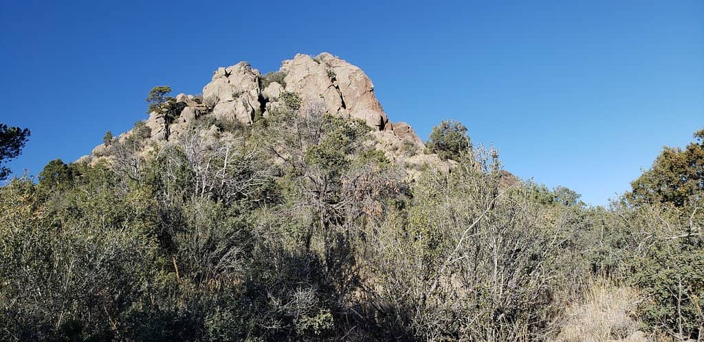
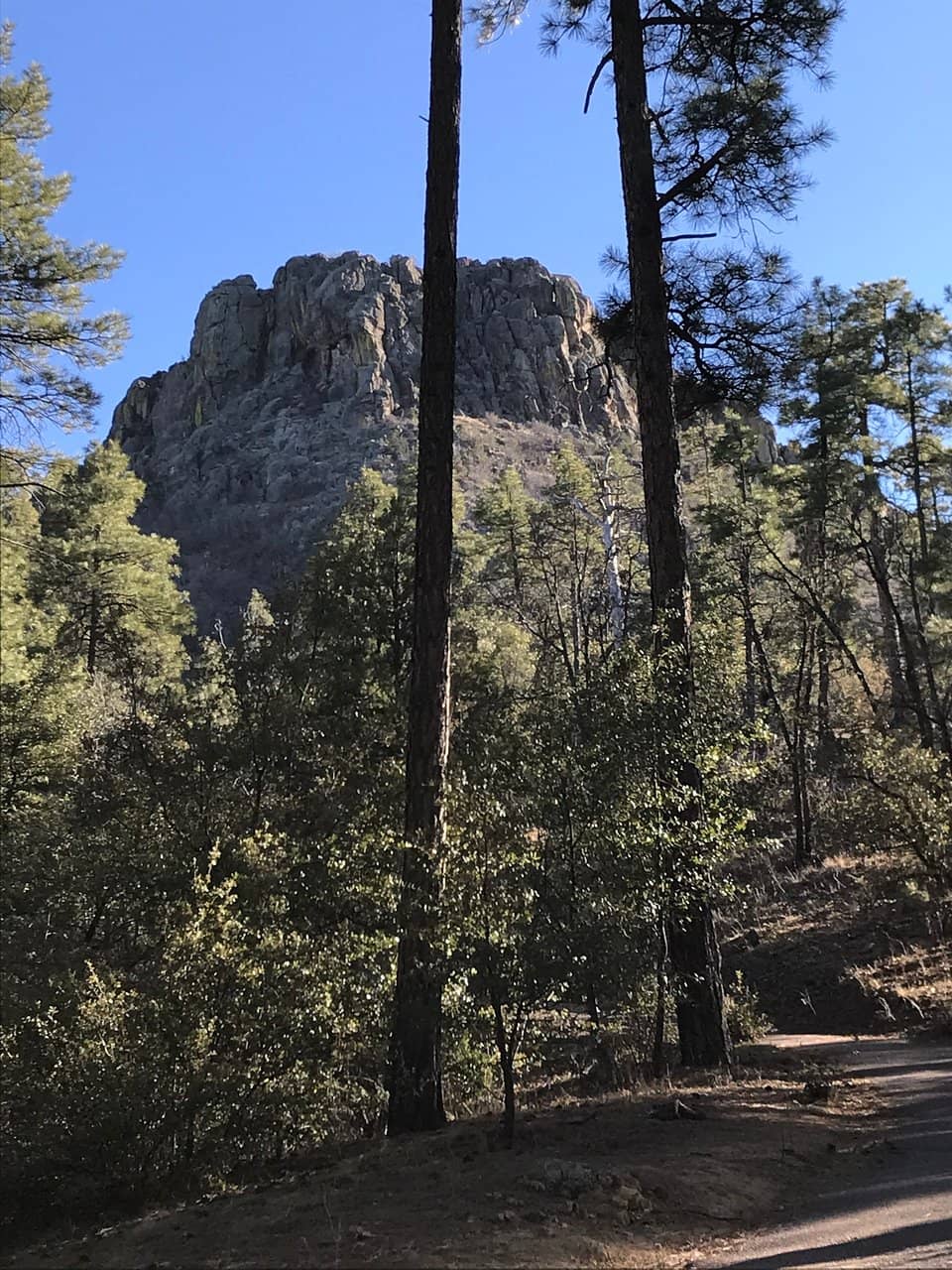
Thumb Butte
Iconic Prescott landmark offering scenic trails with breathtaking panoramic views of the Bradshaw Mountains.
Highlights
Must-see attractions
Social
From TikTok & Reddit
Best Time
Fewer crowds, cooler temps
Thumb Butte
Best Time
Fewer crowds, cooler temps
Highlights
Must-see attractions
Iconic Prescott landmark offering scenic trails with breathtaking panoramic views of the Bradshaw Mountains.
"The symbol of Prescott, AZ, Thumb Butte is the iconic center point of the local skyline."
🚗 Parking Fee
A small fee ($5) is required for parking, and they accept card payments. :moneybag:
🥾 Choose Your Trail Wisely
The main trails are great for families, but the summit path is steep and unmarked. :hiking_boot:
Highlights
Discover the most iconic attractions and experiences
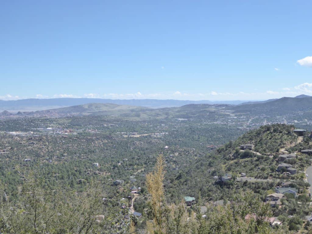
Summit Views
Thumb Butte Summit
Experience breathtaking panoramic views of Prescott and the surrounding Bradshaw Mountains from the top.

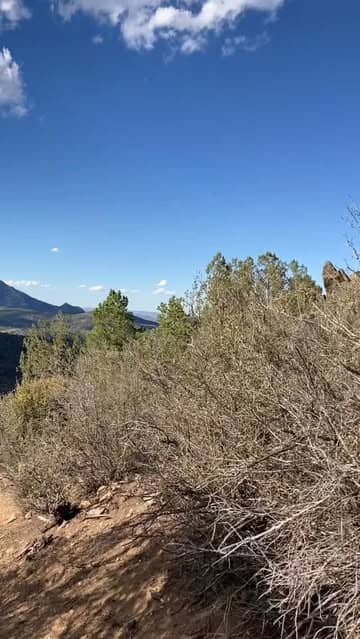
Scenic Loop Trail
Thumb Butte Trailhead
A popular 2.1-mile loop with moderate elevation gain, offering a refreshing escape into nature.
Connector Trail 325
Near Thumb Butte
A favorite among hikers for its scenic beauty and enjoyable trekking experience.
Plans like a pro.
Thinks like you
Planning Your Visit
Timing Your Thumb Butte Adventure
Trail Etiquette and Safety
Best Times
Insider Tips
from TikTok, Instagram & Reddit
🚗 Parking Fee
A small fee ($5) is required for parking, and they accept card payments. :moneybag:
🥾 Choose Your Trail Wisely
The main trails are great for families, but the summit path is steep and unmarked. :hiking_boot:
💧 Hydration is Key
Bring plenty of water, especially if you're not an experienced hiker or visiting during warmer months. :droplet:
📸 Capture the Views
The vistas from Thumb Butte are incredible, perfect for photography and drone shots. :camerawithflash:
Tips
from all over the internet
🚗 Parking Fee
A small fee ($5) is required for parking, and they accept card payments. :moneybag:
🥾 Choose Your Trail Wisely
The main trails are great for families, but the summit path is steep and unmarked. :hiking_boot:
💧 Hydration is Key
Bring plenty of water, especially if you're not an experienced hiker or visiting during warmer months. :droplet:
📸 Capture the Views
The vistas from Thumb Butte are incredible, perfect for photography and drone shots. :camerawithflash:
🚴♀️ Share the Trails
Be aware that mountain bikers also use some of the trails. :mountain_bicyclist:
What Travellers Say
Reviews Summary
Thumb Butte is celebrated as an iconic symbol of Prescott, offering beautiful trails and stunning panoramic views. While the main loop is enjoyable for most, the unmarked summit path is challenging and potentially dangerous. Visitors appreciate the scenic beauty and the rewarding experience, though some note the steepness of certain sections and the need for adequate preparation.
"The symbol of Prescott, AZ, Thumb Butte is the iconic center point of the local skyline. Both paved and dirt trails lead to the saddle and offer great views of downtown Prescott. A much more technical path can take the more adventurous hikers to the summit where they will find truly beautiful views. Please note, this path is unmarked, uneven, and dangerous- proceed at your own risk. The summit is also closed part of the year for Peregrine nesting."
Dakota K
"Great place to hike, nice trails and views!"
D. Adams
"Amazing hike, make sure you take the back way up it's so much more enjoyable. The views are awesome and right now it's not eagle mating season so the ascent is clear. It's 5$ for parking but they do take card there is also a bunch of mountain biking I would like to check out after the daily rain calms down. What are you waiting for get out and hike it!"
_ “XDXC” _
What People Like
What People Dislike
Frequently Asked Questions
🚇 🗺️ Getting There
Thumb Butte is located just west of Prescott, Arizona. You can reach it by taking Thumb Butte Road, which is a paved road for most of the way. The trailhead is well-marked. Some sources mention it's about two miles before it meets Copper Basin Rd.
Public transportation options to Thumb Butte are limited. It's best accessed by private vehicle. Renting a car is recommended for flexibility.
No, you cannot drive to the summit of Thumb Butte. The summit is accessible only by hiking trails. There is a parking area at the trailhead.
While Thumb Butte itself is primarily for hiking, the surrounding areas offer off-roading opportunities. Be sure to research designated trails and regulations beforehand.
The most common route is via Thumb Butte Road from Prescott. It's a scenic drive that leads directly to the trailhead and parking area.
🎫 🎫 Tickets & Entry
Yes, there is a parking fee of $5. They accept card payments at the trailhead.
Thumb Butte is generally accessible during daylight hours. However, it's advisable to check for any seasonal closures, especially during Peregrine nesting periods.
No, advance booking is not required for Thumb Butte. It operates on a first-come, first-served basis for parking and trail access.
Typically, no special permits are required for day hiking on the main trails of Thumb Butte. However, always check with local authorities for any updated regulations.
Thumb Butte is generally open year-round, but it's important to be aware of potential seasonal closures for wildlife protection, such as Peregrine nesting.
🎫 🥾 Onsite Experience
The main loop trail is considered moderate with a 600-foot elevation gain over 2.1 miles. The unmarked summit path is much more technical and steep, not recommended for young children or inexperienced hikers.
The 2.1-mile loop trail typically takes about 1-2 hours to complete, depending on your pace and how often you stop for photos.
Restroom facilities are usually available at the trailhead parking area. It's always a good idea to confirm their availability before your visit.
The main loop trail is generally suitable for families with children, though some sections can be steep. The unmarked summit path is not recommended for young kids.
You'll find stunning panoramic views of Prescott, the surrounding Bradshaw Mountains, and the Ponderosa pine forests.
🍽️ 🍽️ Food & Dining
There are no food services directly at Thumb Butte. You'll need to bring your own snacks and water.
For a great atmosphere, El Gato Azul is highly recommended. Casa Sanchez is also a good option on your way out from the hike.
Picnicking is allowed in designated areas, typically around the trailhead. Remember to pack out all your trash.
Prescott offers a variety of cuisines, from Southwestern and Mexican to American comfort food.
You'll find cafes and coffee shops in downtown Prescott, which is a short drive from Thumb Butte.
📸 📸 Photography
Early mornings and late afternoons offer the best light for photography, with softer shadows and golden hues. Sunset views are particularly spectacular.
Drone usage may be restricted in certain areas or during specific times, especially if there are wildlife nesting sites. Always check local regulations before flying.
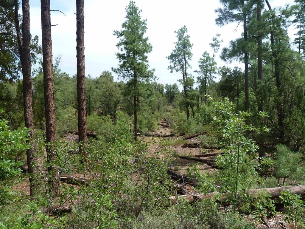
The summit offers expansive panoramic views. The trails themselves, with the Ponderosa pines and rock formations, also make for beautiful shots.
Absolutely! Sunset from Thumb Butte provides stunning colors and a memorable backdrop for photos.
A wide-angle lens is great for capturing the panoramic views. A telephoto lens can be useful for wildlife spotting. Don't forget a sturdy tripod for low-light conditions.
For Different Travelers
Tailored advice for your travel style
👨👩👧 Families with Kids
👟 Fitness Enthusiasts & Trail Runners
📸 Photographers & Drone Enthusiasts
Deep Dives
In-depth insights and expert knowledge
Navigating the Trails of Thumb Butte
For the more adventurous, there's an unmarked, technical path that leads to the summit. This route is significantly steeper, uneven, and requires caution. It's crucial to proceed at your own risk and be well-prepared with appropriate gear and ample water.
Several connector trails also weave through the area, such as Trail 315 (Watertower) and Trail 317 (Ridge Top Trail), offering opportunities for longer hikes or trail running.
The Iconic Symbol of Prescott
Historically, Thumb Butte has been a focal point for outdoor recreation. Its trails have been used for generations, offering a accessible way for people to connect with the rugged Arizona landscape. The views from its trails provide a unique perspective on Prescott, showcasing its integration with the natural environment.
Beyond its visual appeal, Thumb Butte holds personal significance for many. Some visitors, like those undertaking challenges such as '75Hard,' find conquering the butte to be a deeply rewarding personal achievement.


Social
from TikTok, Instagram & Reddit