
Mount Wantastiquet
Conquer Mount Wantastiquet for breathtaking summit views and a rugged, rewarding hike through nature's obstacles.
Highlights
Must-see attractions

Social
From TikTok & Reddit
Best Time
Waterfalls are at their peak
Mount Wantastiquet
Best Time
Waterfalls are at their peak
Highlights
Must-see attractions
Conquer Mount Wantastiquet for breathtaking summit views and a rugged, rewarding hike through nature's obstacles.
"The summit views are worth the challenging, rocky, and rooty trail!"

👟 Wear sturdy hiking shoes
The trail is known for its rocks and roots, so good footwear is essential for a comfortable hike .
💧 Check for mud & water
Spring rains can make parts of the trail wet and muddy, with beautiful waterfalls appearing .
Highlights
Discover the most iconic attractions and experiences
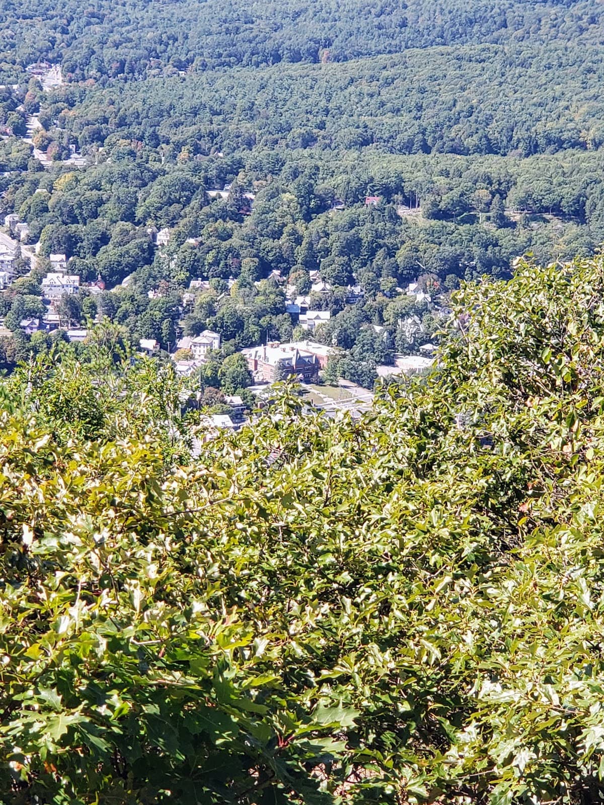
Summit Views
Panoramic vistas await at the top, offering a stunning reward for your climb. A must-see for any visitor.
Pond at the Summit
A serene pond nestled at the mountain's peak, providing a unique and tranquil spot to rest.

Rocky & Rooty Terrain
Embrace the natural challenge of the trail, featuring an authentic, rugged hiking experience.
Plans like a pro.
Thinks like you
Planning Your Visit
Trail Conditions & Timing
Solo Hiking & Safety
Best Times
Insider Tips
from TikTok, Instagram & Reddit
👟 Wear sturdy hiking shoes
The trail is known for its rocks and roots, so good footwear is essential for a comfortable hike.
💧 Check for mud & water
Spring rains can make parts of the trail wet and muddy, with beautiful waterfalls appearing.
🗺️ Download trail map
Having a 'mount wantastiquet trail map' handy ensures you stay on course, especially for longer hikes.
💪 Be prepared for a climb
This hike can be challenging, so bring water and be ready for a good workout.
Solo Hiking Wantastiquet - safety concerns?
Tips
from all over the internet
👟 Wear sturdy hiking shoes
The trail is known for its rocks and roots, so good footwear is essential for a comfortable hike.
💧 Check for mud & water
Spring rains can make parts of the trail wet and muddy, with beautiful waterfalls appearing.
🗺️ Download trail map
Having a 'mount wantastiquet trail map' handy ensures you stay on course, especially for longer hikes.
💪 Be prepared for a climb
This hike can be challenging, so bring water and be ready for a good workout.
What Travellers Say
Reviews Summary
Hikers praise Mount Wantastiquet for its rewarding summit views and challenging, natural trail. The rocky and rooty terrain offers an authentic hiking experience, with a unique pond at the peak. Some visitors note the trail can be muddy in spring, and solo hikers should be mindful of their surroundings.
"4.4 mile hike round trip, nice wide trail to follow and worth a trip upnyo the summit views."
Sal
""
Elizabeth Rodriguez
What People Like
What People Dislike
Frequently Asked Questions
🚇 🗺️ Getting There
Mount Wantastiquet is accessible via various trailheads. The main access point is typically from Brattleboro, Vermont. It's recommended to use a GPS or mapping app to find the specific trailhead you plan to use. Consider downloading a 'mount wantastiquet trail map' before you go.
Parking availability can vary depending on the trailhead. It's advisable to arrive early, especially on weekends or during peak seasons, to secure a spot. Some trailheads might have limited parking.
Yes, it's possible to connect Mount Wantastiquet with Madam Sherri Castle, creating a longer, more adventurous hike. This route offers a unique experience but requires careful planning and navigation.
While the main trail is generally well-defined, having a 'mount wantastiquet trail map' is highly recommended. Many hikers also use navigation apps on their phones for added security.
Public transport options directly to the trailheads are limited. It's generally best to drive or arrange for a ride-share service to reach the starting point of your hike.
🎫 🎫 Tickets & Entry
No, Mount Wantastiquet is a natural area and typically does not require an entrance fee or tickets for hiking. Enjoy the natural beauty for free!
As a natural outdoor area, Mount Wantastiquet is generally accessible from dawn until dusk. There are no official operating hours, but it's best to hike during daylight for safety.
Parking at most trailheads for Mount Wantastiquet is usually free. However, it's always a good idea to check for any posted signage at the specific trailhead you are using.
While official guided tours might be infrequent, local hiking groups or outdoor enthusiasts sometimes organize group hikes. Check local community boards or outdoor recreation pages.
Generally, no permits are required for day hiking on Mount Wantastiquet. However, if you plan on any overnight camping or specific activities, it's wise to check with local authorities.
🎫 🥾 Onsite Experience
The Mount Wantastiquet trail is considered moderate to challenging. It involves a significant elevation gain and features rocky and rooty sections, making it a good workout.+1
The round trip hike is approximately 4.4 miles. Depending on your pace and how long you spend at the summit, the hike can take anywhere from 2 to 4 hours.
The summit offers rewarding panoramic views of the surrounding landscape, including the Connecticut River Valley and potentially parts of New Hampshire. The views are a major draw for hikers.
Restroom facilities are typically not available directly on the trail. It's best to use facilities at a nearby park or your starting point before beginning your hike.
Dogs are generally allowed on the Mount Wantastiquet trails, but they must be kept on a leash. Always clean up after your pet.
📸 📸 Photography
The summit offers the most spectacular panoramic views, perfect for landscape photography. Don't miss the unique pond at the peak for a different perspective.
Golden hour, shortly after sunrise or before sunset, provides the most flattering light for photography. Spring mornings can also be great for capturing waterfall shots.
A wide-angle lens is great for capturing the expansive summit views. A sturdy tripod can be helpful for low-light conditions or long exposures. Consider a polarizing filter to enhance sky and water colors.
The trail itself offers many opportunities, with its natural rock formations, exposed roots, and lush greenery. The pond at the summit is also a distinctive subject.
Use a lower camera angle to emphasize the texture and scale of the rocks and roots. Look for interesting patterns and leading lines within the trail's natural features.
For Different Travelers
Tailored advice for your travel style
👨👩👧 Families with Kids
For a slightly less strenuous experience, focus on reaching the pond at the summit as a primary goal. This provides a unique destination and a chance for a peaceful break. If visiting in spring, the waterfalls can be an exciting bonus for children, adding an element of discovery to the hike.
Solo Adventurers
Be prepared for the rocky and rooty terrain
Deep Dives
In-depth insights and expert knowledge
Navigating the Mount Wantastiquet Trail
Hikers often mention the elevation gain as a key characteristic of the hike. While not excessively steep, the sustained climb requires a decent level of fitness. Many visitors find the summit views to be the ultimate payoff, providing expansive panoramas of the Connecticut River Valley and surrounding areas. For those looking for a unique feature, a pond at the summit offers a tranquil spot to rest and take in the scenery.
When planning your hike, consulting a 'mount wantastiquet trail map' is highly recommended. While the main path is generally clear, having a map can help with orientation, especially if you decide to explore any connecting paths or if conditions are less than ideal. Spring can bring increased water flow, leading to beautiful waterfalls along the trail, but also potentially muddier conditions.
Connecting with Madam Sherri Castle
This extended trek provides a deeper immersion into the local landscape and history. You'll traverse varied terrain, from the rugged trails of Mount Wantastiquet to potentially more established paths leading towards the castle ruins. The Madam Sherri Castle itself, though a ruin, offers a fascinating glimpse into the past and a unique backdrop for photos.
When planning this combined adventure, ensure you have a reliable 'mount wantastiquet trail map' that also covers the routes to the castle. Pack ample water, snacks, and be prepared for a longer day outdoors. Informing someone of your extended itinerary is crucial for safety, especially if hiking solo.


Social
from TikTok, Instagram & Reddit