
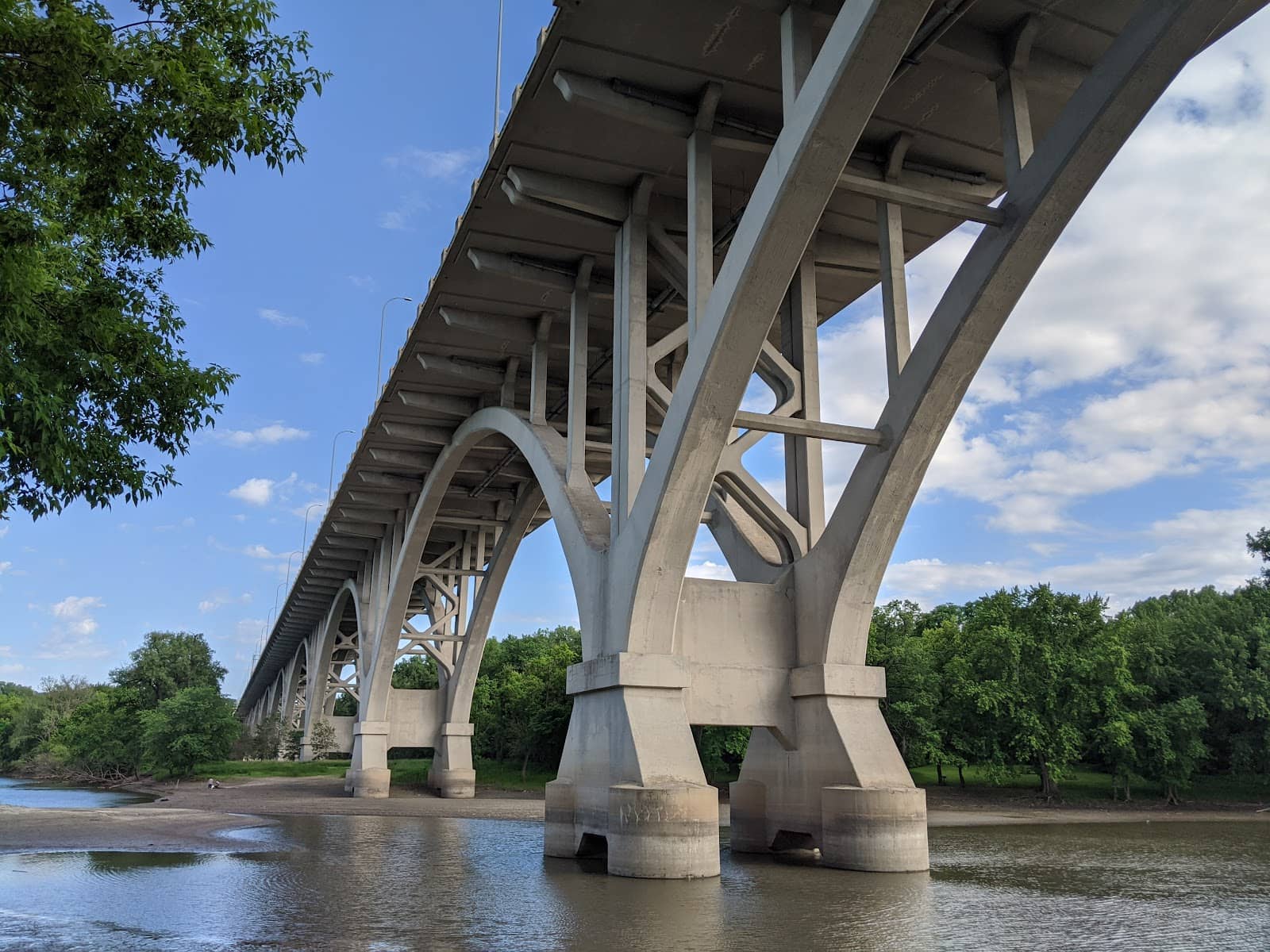
Mendota Bridge Overlook
A vital river crossing offering sweeping views of Minneapolis and St. Paul, connecting extensive trail networks.
Highlights
Must-see attractions

Social
From TikTok & Reddit
Best Time
Best for panoramic views
Mendota Bridge Overlook
Best Time
Best for panoramic views
Highlights
Must-see attractions
A vital river crossing offering sweeping views of Minneapolis and St. Paul, connecting extensive trail networks.
"Beautiful views of both downtowns and Fort Snelling, from the bike path."
🚴♀️ Watch Your Knuckles!
Be mindful of the narrow railings on the bike path, especially when passing others. :athletic_shoe:
🗺️ Explore the Trails
Connect to extensive paved trails leading to Minneapolis, St. Paul, and more. :world_map:

Quick Facts
Hours
Rating
4.3 · 30 reviews
Highlights
Discover the most iconic attractions and experiences
Panoramic City Views
Pedestrian/Bike Path
Enjoy breathtaking vistas of both downtown Minneapolis and St. Paul from this unique vantage point.
Fort Snelling Perspective
Pedestrian/Bike Path
Gain a unique aerial perspective of the historic Fort Snelling, offering a different angle on its significance.

Storm Watching Spot
Pedestrian/Bike Path
Witness dramatic storm clouds gather over the Minnesota landscape from this elevated position.
Plans like a pro.
Thinks like you
Planning Your Visit
Mind the Railings!
Connect to Trails
Best Times
Insider Tips
from TikTok, Instagram & Reddit
🚴♀️ Watch Your Knuckles!
Be mindful of the narrow railings on the bike path, especially when passing others. :athletic_shoe:
🗺️ Explore the Trails
Connect to extensive paved trails leading to Minneapolis, St. Paul, and more. :world_map:
Does anyone know how to access the Mendota Bridge walking path?
My friend from out of state is visiting soon and I’m wondering how I can access the Mendota Bridge (Hwy 55) walking/bike lanes. I cross the bridge a couple of times a week for work and see that they’re there, but can’t find much info online about it.
Mendota Bridge guardrails will be raised a foot. The project will cost $2.5 million.
Hi fellow cyclists, A few months ago this group helped me write a story about the rails on the Mendota Bridge being too low. Last week, I saw MnDOT decided they are going to increase the height of the rails on the bridge. Curious to know what people's thoughts are on this.…
⚡ Stormy Skies
Great spot for dramatic photos of approaching storms. :camerawithflash:
🚗 Convenient Crossing
Essential for crossing the river, especially if using Hwy 62. 🚗
Mendota Bridge Closed to Pedestrians/Cyclists for 2026 to Fix Railing Height
Dang that really sucks for my biking loop but yeah those railings are insanely low. If you have a bike that you sit up high on, a good wind gust could literally toss you over the side.
Tips
from all over the internet
🚴♀️ Watch Your Knuckles!
Be mindful of the narrow railings on the bike path, especially when passing others. :athletic_shoe:
🗺️ Explore the Trails
Connect to extensive paved trails leading to Minneapolis, St. Paul, and more. :world_map:
⚡ Stormy Skies
Great spot for dramatic photos of approaching storms. :camerawithflash:
🚗 Convenient Crossing
Essential for crossing the river, especially if using Hwy 62. 🚗
What Travellers Say
Reviews Summary
Visitors appreciate the Mendota Bridge for its stunning panoramic views of both Minneapolis and St. Paul, as well as its convenient role as a river crossing and trail connector. While the bridge's structure and narrow railings have been noted as minor drawbacks, recent repair work and planned safety improvements are enhancing the experience.
"Beautiful views of both downtowns and Fort Snelling, from the bike path. But go slow when passing other bikes or you may scrape your knuckles on the narrow railing. The bike paths on both ends connect to some great paved trails heading to Minneapolis, St Paul, Eagan, or Mendota."
Paul M
"This bridge does a great job. I’ve never been let down by this bridge, and it’s especially convenient if you need to cross the river while using Hwy 62. I highly recommend it. Also, very cool view of both downtowns."
Julia Kading
"Thank you MnDOT for fixing and repairing the pavement of the bridge (in 2022)! We’ll see how long that holds up. Bridge structure still looks concerning to me. Still wish they had more law enforcement on the bridge since there’s way too many bad drivers and terrible merging/mergers. Other than that, biking or walking on the pedestrian sidewalks of the bridge is nice and has great views."
Pauly C.
What People Like
What People Dislike
Frequently Asked Questions
🚇 🗺️ Getting There
The overlook is best accessed via the pedestrian and bike paths on either side of the Mendota Bridge. These paths connect to a larger network of paved trails, making it easily reachable by bicycle or on foot.
While direct parking at the overlook itself is limited, there are parking areas available at trailheads that connect to the bridge's pedestrian paths. Consider parking at nearby parks or trail access points.
You can drive across the Mendota Bridge, but the 'overlook' experience is primarily from the pedestrian and bike paths. There are no dedicated viewing platforms for cars.
Bus routes may pass near the bridge, but direct access to the pedestrian paths via public transport might require some walking. Check local transit maps for routes serving the Mendota or Fort Snelling areas.
The bike paths on both ends of the bridge link to extensive paved trails heading towards Minneapolis, St. Paul, Eagan, and Mendota, offering many route possibilities.
🎫 🎫 Tickets & Entry
No, there is no admission fee to access the pedestrian and bike paths on the Mendota Bridge. It's a public thoroughfare and viewing area.
The bridge and its pedestrian paths are accessible 24/7, as it's a public road and trail system. However, visibility for views is best during daylight hours.
No advance booking is necessary. The Mendota Bridge is a public infrastructure, and its pedestrian and bike paths are open to everyone.
Generally, the paths are open for walking and cycling. Be mindful of traffic and other users, and adhere to any posted signage.
The pedestrian and bike paths are paved and generally accessible, though they are part of a bridge structure. It's advisable to check for any specific accessibility updates from MnDOT.
📸 📸 Photography
Golden hour (shortly after sunrise and before sunset) offers beautiful lighting for cityscapes. Stormy weather also provides dramatic backdrops for unique shots.
You can capture panoramic views of downtown Minneapolis and St. Paul, the historic Fort Snelling, and the Minnesota River valley. It's also a great spot for storm photography.
There are no specific photography restrictions mentioned, but always be aware of your surroundings and avoid obstructing traffic or other users on the paths.
A wide-angle lens is ideal for capturing the expansive city views. A telephoto lens can be useful for isolating details of the skylines or Fort Snelling.
Drone usage is subject to FAA regulations and local restrictions. It's advisable to check current regulations before flying a drone in this area, especially given its proximity to transportation infrastructure.


Social
from TikTok, Instagram & Reddit