
Salmon Creek Trail and Reservoir
Hike to a stunning jade-green reservoir with cascading waterfalls, offering challenging terrain and rewarding panoramic views.
Highlights
Must-see attractions
Social
From TikTok & Reddit
Best Time
Clearer views, fewer crowds
Salmon Creek Trail and Reservoir
Best Time
Clearer views, fewer crowds
Highlights
Must-see attractions
Hike to a stunning jade-green reservoir with cascading waterfalls, offering challenging terrain and rewarding panoramic views.
"The water is stunning jade green in color with cascading waterfalls from the surrounding basin."

🎯 Bike the Gravel Road
Bring a bike for the first 2 miles of gravel road to save energy for the steeper climb.
👟 Sturdy Hiking Shoes
Essential for the slippery roots and rocks on the final ascent, especially after rain.
Highlights
Discover the most iconic attractions and experiences
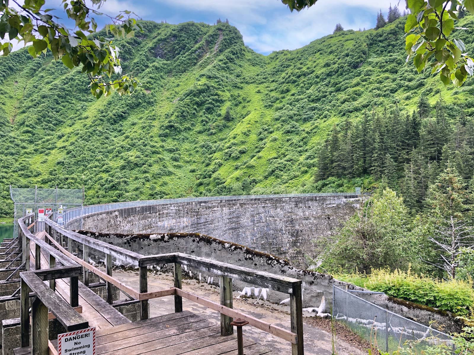
Salmon Creek Reservoir Dam
End of the trail
Stunning jade-green water, cascading waterfalls, and panoramic mountain views await at this historic 1914 dam.
Forest Trail Ascent
Upper section of the trail
A recently upgraded, steep climb through tall spruce and hemlock, rewarding hikers with breathtaking natural beauty.

Gravel Road Section
Lower section of the trail
The initial 2 miles offer a gentler, wide gravel path, perfect for a brisk walk or even a bike ride.
Plans like a pro.
Thinks like you
Planning Your Visit
Trailhead Access & Timing
Footwear & Conditions
Best Times
Insider Tips
from TikTok, Instagram & Reddit
🎯 Bike the Gravel Road
Bring a bike for the first 2 miles of gravel road to save energy for the steeper climb.
👟 Sturdy Hiking Shoes
Essential for the slippery roots and rocks on the final ascent, especially after rain.
🐶 Dogs on Leash (Mostly)
Dogs are allowed on the trail but not up to the reservoir itself. Remember to clean up after them.
📍 Trailhead Navigation
Look for a sharp turn off Egan northbound after the embankment wall; signage can be hard to spot.
Tips
from all over the internet
🎯 Bike the Gravel Road
Bring a bike for the first 2 miles of gravel road to save energy for the steeper climb.
👟 Sturdy Hiking Shoes
Essential for the slippery roots and rocks on the final ascent, especially after rain.
🐶 Dogs on Leash (Mostly)
Dogs are allowed on the trail but not up to the reservoir itself. Remember to clean up after them.
📍 Trailhead Navigation
Look for a sharp turn off Egan northbound after the embankment wall; signage can be hard to spot.
🎣 Fishing Opportunities
Anglers can try their luck for eastern brook trout at the reservoir.
What Travellers Say
Reviews Summary
Salmon Creek Trail is praised for its stunning jade-green reservoir and cascading waterfalls, offering breathtaking views that are well worth the effort. While the initial gravel road is easy, the final ascent is steep and challenging, requiring good footwear. Some find the trailhead navigation tricky, but the overall experience is highly rewarding for nature lovers and hikers.
"Well maintained trail to Salmon Creek Dam and reservoir. The dam was built in 1914 and serves at the Juneau Community’s drinking water reservoir. Trail is in great shape. It is about 6.6 miles round trip on gravel trail with the last 1.25 miles on maintained trail through tall spruce and hemlock. There are roots exposed and a steep exposed section with stairs. The water is stunning jade green in color with cascading waterfalls from the surrounding basin.
Dogs are welcome with the exception of up to the reservoir.
Wear good tread hiking shoes if doing this in the rain as the roots and rocks become very slick."
Kristen Abt
"Great hike, the end is a strenuous climb up roots and rocks, but like most trails in Juneau, the views are worth it!"
Matt Stone
"A great hike with breathtaking and just amazing view. The hike is moderate to very hard but it's all worth it."
Virginia Kelly
What People Like
What People Dislike
Frequently Asked Questions
🚇 🗺️ Getting There
The trailhead access can be confusing. From Egan Drive northbound, look for a sharp turn after the embankment wall. Avoid routes that direct you behind the hospital or around Channel Vista Drive.
While not directly on public transport routes, cruise ship excursions often include transport to the trailhead. If hiking independently, consider a taxi or rideshare.
Yes, the first 2 miles of the trail are a wide gravel road, making it suitable for biking. This can save energy for the steeper ascent.
Use a reliable GPS or map application, and be aware of the specific turn-off from Egan Drive. The signage can be subtle.
Some cruise lines offer specific excursions that include transportation to the Salmon Creek Trail and Reservoir. Check with your cruise provider.
🎫 🎫 Tickets & Entry
There is no entrance fee for Salmon Creek Trail. It is a public access area for hiking and recreation.
Salmon Creek Trail is generally open year-round during daylight hours. Access to the reservoir area may have specific restrictions.
No, tickets are not required for Salmon Creek Trail. It's a natural trail system open to the public.
Dogs are welcome on the trail but are not permitted up to the reservoir itself. Please keep them leashed and clean up after them.
Summer and early fall offer the best hiking conditions with less snow and ice. Wildflowers and berries are often visible in season.
🎫 🏞️ Onsite Experience
The round trip is about 6.6 miles. While some reviews mention 5-6 hours, many hikers complete it in 1.5-3 hours at a moderate pace.
The trail is considered moderate to very hard. The first 2/3 is a gravel road, but the last mile involves a steep, strenuous climb with roots and stairs.
Expect stunning jade-green water, cascading waterfalls from the surrounding basin, and beautiful forest and mountain views.
There is a nice tent/picnic platform at the top near the dam, offering a great spot to relax and enjoy the views. Restroom facilities are limited.
The initial gravel road is manageable, but the steep, root-filled final ascent might be challenging for very young children or those with mobility issues.
📸 📸 Photography
The reservoir's jade-green water, the cascading waterfalls, and the panoramic mountain vistas from the dam are prime photo spots. The forest trail also offers beautiful shots.
Late afternoon often provides beautiful golden hour light. Morning can offer clearer skies and fewer people.
A wide-angle lens is great for capturing the expansive views. Consider a polarizing filter to enhance the water's color.
While one user mentioned using a drone for aerial views, it's always best to check local regulations regarding drone usage in protected watershed areas.
Try capturing the dam from different elevations, looking down at the reservoir or up at the surrounding mountains. The trail leading to it also provides scenic framing.
For Different Travelers
Tailored advice for your travel style
👨👩👧 Families with Kids
🚶♀️ Avid Hikers & Cruise Day-Trippers
🐶 Dog Owners
Deep Dives
In-depth insights and expert knowledge
The Hike: From Gravel to Summit
The latter part of the hike, approximately the final 1.25 miles, is where the challenge truly lies. This segment is significantly steeper, featuring exposed roots and a series of stairs that require careful footing. It's a strenuous climb, but the effort is rewarded with increasingly dramatic views as you ascend through the tall spruce and hemlock trees.
Trail conditions can vary, especially after rain, making the roots and rocks slick. Proper footwear with good tread is highly recommended. The trail has been recently upgraded by volunteers, enhancing the experience for hikers.
Salmon Creek Reservoir: A Vital Water Source
At the reservoir's edge, visitors can find a pleasant tent and picnic platform, offering a perfect spot to rest, enjoy a meal, or simply soak in the breathtaking views of the water, mountains, and forest. For anglers, the reservoir is known to be stocked with eastern brook trout, providing an opportunity for fishing.
It's crucial for visitors to respect the reservoir's role as a water source. Keeping the area clean and picking up any dog waste is paramount to maintaining its pristine condition for the community.
Navigating to the Trailhead
The key is to look for a sharp turn-off from Egan Drive when heading northbound. This turn is located just after a noticeable embankment wall. The signage for the trailhead itself can be subtle and easily missed, so paying close attention to your surroundings as you drive is advised.
Many reviewers suggest that the first section of the trail, being a gravel road, is ideal for biking. If you have the means, bringing a bike can significantly speed up your journey to the more challenging, scenic upper portion of the trail, making the overall experience more efficient.


Social
from TikTok, Instagram & Reddit