
Brand Motorway Trail
A steep, rewarding trail from Brand Park to Mt. Thom's summit, offering challenging climbs and panoramic Glendale views.
Highlights
Must-see attractions

Social
From TikTok & Reddit
Best Time
Avoid midday heat
Brand Motorway Trail
Best Time
Avoid midday heat
Highlights
Must-see attractions
A steep, rewarding trail from Brand Park to Mt. Thom's summit, offering challenging climbs and panoramic Glendale views.
"It's a steep climb, but the views from the top are worth every step!"

💧 Bring Ample Water
Crucial for the steep ascent, especially during warmer hours. Stay hydrated!
👟 Wear Sturdy Shoes
The trail is steep and can be uneven. Good grip is essential for a safe hike. :athletic_shoe:

Highlights
Discover the most iconic attractions and experiences

Radio Tower Summit
Mt. Thom
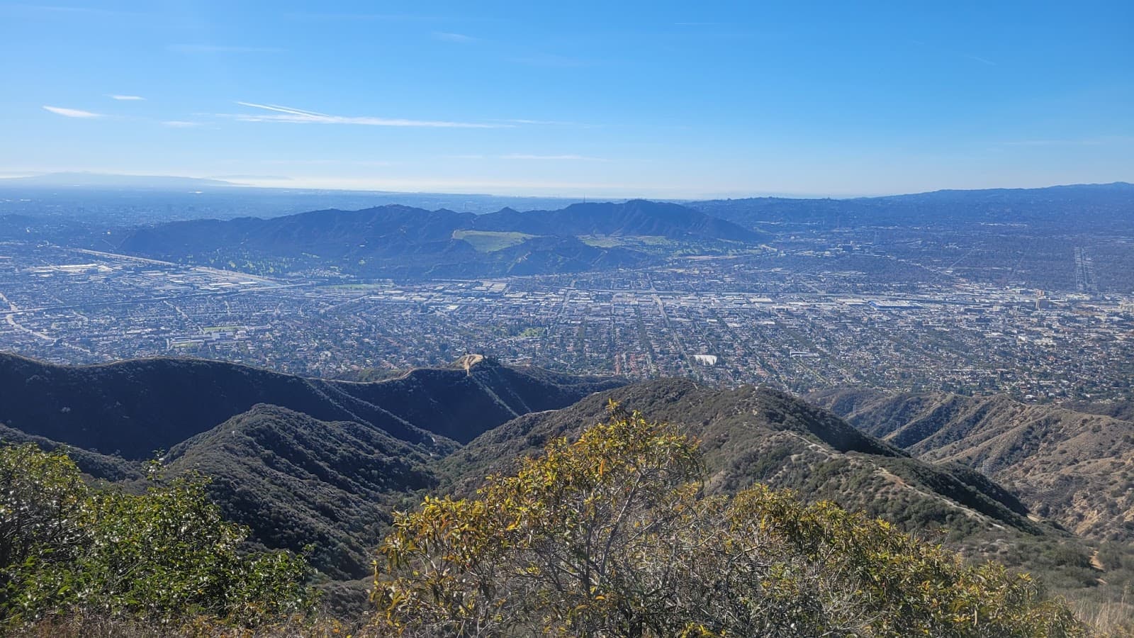
Reach the summit for panoramic views after a steep, rewarding climb. A true test of endurance!
Brand Library Trailhead
Brand Park
Start your adventure from this scenic park, offering a direct and challenging ascent.
Plans like a pro.
Thinks like you
Planning Your Visit
Trail Conditions & Timing
Trail Name & Access
Best Times
Insider Tips
from TikTok, Instagram & Reddit
💧 Bring Ample Water
Crucial for the steep ascent, especially during warmer hours. Stay hydrated!
👟 Wear Sturdy Shoes
The trail is steep and can be uneven. Good grip is essential for a safe hike. :athletic_shoe:
Has anyone hiked the trail that goes from Brand Library straight up to the radio towers on Mt. Thom?
Is this trail run connection possible?
⬆️ Prepare for Steepness
The first third of the trail is very steep. Pace yourself and enjoy the challenge. :hiking_boot:
📍 Know Your Starting Point
The trail begins near Brand Library, offering a direct route to the summit. :round_pushpin:
Verdugo Mountains Bear Sighting
Tips
from all over the internet
💧 Bring Ample Water
Crucial for the steep ascent, especially during warmer hours. Stay hydrated!
👟 Wear Sturdy Shoes
The trail is steep and can be uneven. Good grip is essential for a safe hike. :athletic_shoe:
⬆️ Prepare for Steepness
The first third of the trail is very steep. Pace yourself and enjoy the challenge. :hiking_boot:
📍 Know Your Starting Point
The trail begins near Brand Library, offering a direct route to the summit. :round_pushpin:
What Travellers Say
Reviews Summary
The Brand Motorway Trail is praised for its challenging, steep climb and rewarding summit views of Glendale. Hikers appreciate the direct route from Brand Park, though many emphasize the need for ample water and sturdy footwear due to the trail's demanding nature. It's a great option for a quick, intense workout with a scenic payoff.
What People Like
What People Dislike
Frequently Asked Questions
🚇 🗺️ Getting There
The trail starts from Brand Park, near the Brand Library in Glendale. You can park at the library or in designated areas within the park.
Yes, parking is generally available at Brand Park, though it can fill up on busy days. Arrive early for the best spots. :car:
From the Brand Library, look for the trail entrance that leads directly up the hillside towards Mt. Thom. It's a well-defined path.
🎫 🎫 Tickets & Entry
No, the Brand Motorway Trail is a public park trail and does not require an entrance fee or ticket. It's free to access. :ticket:
Brand Park is generally open from sunrise to sunset. Always check local park advisories for any specific closures or changes. :clock1:
🎫 🥾 Onsite Experience
The trail is considered steep, especially in the first third. It's a challenging but manageable hike for those with moderate fitness.
It typically takes about an hour to reach the radio towers at the summit from the Brand Library fork.
The summit offers panoramic views of the surrounding Glendale area and beyond. It's a great reward for the climb. :cityscape:
While doable, the steepness might be challenging for absolute beginners. It's recommended for those with some hiking experience or good stamina. :runner:
The trail itself is a natural path. Amenities like restrooms and water fountains are available at Brand Park before you begin your ascent. :water_wave:
📸 📸 Photography
The summit offers the most expansive views. Midway points on the trail also provide interesting perspectives of the landscape. :camerawithflash:
Early morning or late afternoon light provides softer, more flattering illumination for photos and can create beautiful golden hour shots. :sunrise:
For Different Travelers
Tailored advice for your travel style
💪 Fitness Enthusiasts
📸 Photographers
Deep Dives
In-depth insights and expert knowledge
The Ascent: Trail Features and Challenges
Preparation is key for this hike. Given the direct exposure and exertion, carrying ample water is non-negotiable, especially if you plan to hike around lunchtime.
Summit Views and Destination
While the trail itself is a natural path, the summit area is functional, serving the radio towers. However, the expansive views make it a worthwhile endpoint. It's a place where you can catch your breath, enjoy the scenery, and appreciate the effort it took to get there. The clear, open space at the top contrasts with the enclosed, steep trail, offering a sense of arrival and perspective.


Social
from TikTok, Instagram & Reddit