
Sheltowee Trace Trail
A rugged, 300+ mile trail through Kentucky's wilderness, offering challenging hikes, unique caves, and stunning natural beauty.
Highlights
Must-see attractions

Social
From TikTok & Reddit
Best Time
Ideal for milder weather
Sheltowee Trace Trail
Best Time
Ideal for milder weather
Highlights
Must-see attractions
A rugged, 300+ mile trail through Kentucky's wilderness, offering challenging hikes, unique caves, and stunning natural beauty.
"A very challenging trail! Beautiful and wild wilderness."
🚗 Parking is Tricky!
Limited parking at trailheads. Research access points or consider biking/shuttles.
🗺️ Get Your Maps Ready
Essential for navigation. Look for detailed maps of Sheltowee Trace Trail sections.

Highlights
Discover the most iconic attractions and experiences
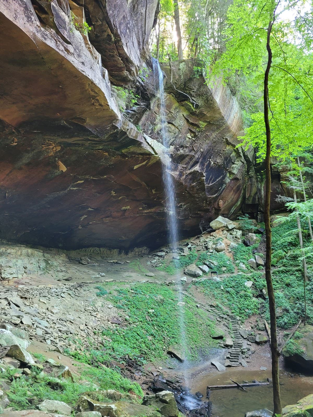
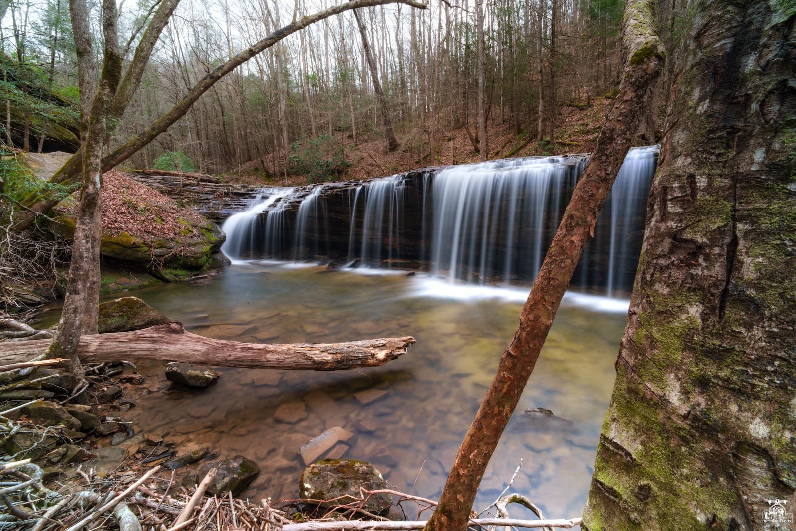
Resurgence Cave
Sheltowee Trace Trail
Discover the hidden depths of Resurgence Cave, a unique geological wonder along the trail.
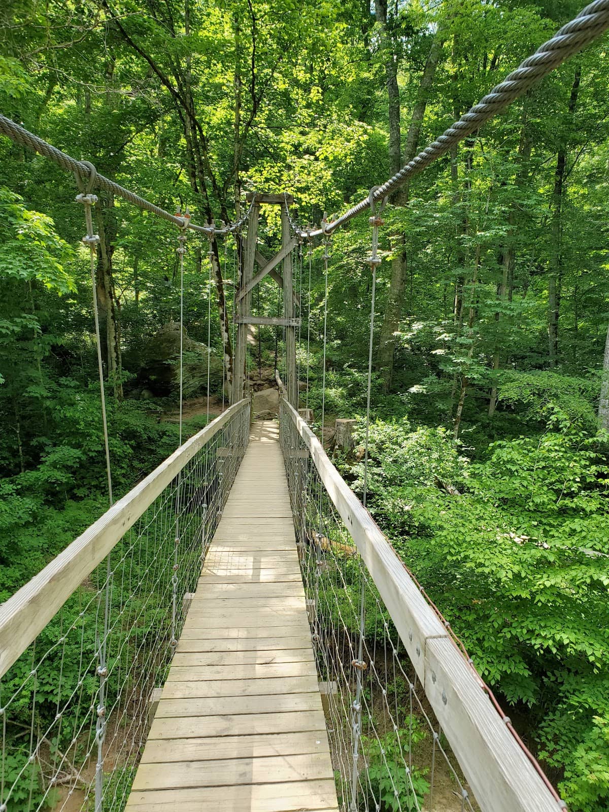
Suspension Bridge
Sheltowee Trace Trail
Experience the thrill of crossing a picturesque suspension bridge, a memorable landmark.
Jumping Rock
Sheltowee Trace Trail
Test your adventurous spirit at Jumping Rock, a popular spot for scenic views and a daring leap.
Jurassic Park-like Forests
Sheltowee Trace Trail
Hike through ancient forests with towering trees and lush undergrowth, evoking a prehistoric landscape.
Plans like a pro.
Thinks like you
Planning Your Visit
Embrace the Wilderness: Prepare for a True Backcountry Experience
Navigating the Trace: Parking and Trail Access
Best Times
Insider Tips
from TikTok, Instagram & Reddit
🚗 Parking is Tricky!
Limited parking at trailheads. Research access points or consider biking/shuttles. +1
🗺️ Get Your Maps Ready
Essential for navigation. Look for detailed maps of Sheltowee Trace Trail sections.
🐺 Beware of Farm Dogs
Some sections have farm dogs that can be territorial. Be cautious and prepared.
💧 Water Sources Vary
Carry enough water or have a reliable filter. Creek access can be inconsistent.
Tips
from all over the internet
🚗 Parking is Tricky!
Limited parking at trailheads. Research access points or consider biking/shuttles. +1
🗺️ Get Your Maps Ready
Essential for navigation. Look for detailed maps of Sheltowee Trace Trail sections.
🐺 Beware of Farm Dogs
Some sections have farm dogs that can be territorial. Be cautious and prepared.
💧 Water Sources Vary
Carry enough water or have a reliable filter. Creek access can be inconsistent.
🥾 Sturdy Footwear Needed
The trail is challenging. Good hiking boots are a must for comfort and safety.
What Travellers Say
Reviews Summary
The Sheltowee Trace Trail is lauded for its wild, challenging beauty, offering a true wilderness experience with stunning natural landmarks like suspension bridges and unique caves. However, visitors frequently mention significant challenges with parking availability at trailheads and the rugged, demanding nature of the terrain.
"Love the suspension bridge and jumping rock along this trail. Not alot of parking opportunities if not in a Jeep."
Johneydenise Barnhill
"Very challenging trail! Beautiful and wild wilderness. I challenge all my hiker friends to this 325 mile long trail.🙂"
Patriot / Kenneth Burlingham
"This Forest so beautiful the people who live inside this beautiful Forest are blessed from the state line with tn. All the way north is beautiful and the people are so kind and helpful go take a ride to Kentucky and don't forget to see cumberland falls"
willie Oakley
What People Like
What People Dislike
Frequently Asked Questions
🚇 🗺️ Getting There
Access points vary greatly. Some popular trailheads include the McKee trailhead. However, parking can be extremely limited, with some users reporting needing to park over 10 miles away or use bikes to reach the trail. Research specific access points and consider shuttle services or local advice. +1
While you can drive to many access points, parking is often scarce. Some areas are down narrow roads with no shoulder, making it difficult for standard vehicles. Jeeps or bikes might be more suitable for certain access points.
While some sections might be suitable for bikepacking, the Sheltowee Trace Trail is primarily a hiking trail and can be very rugged. Check specific trail conditions and regulations for bikepacking.
Having a detailed map of the Sheltowee Trace Trail is crucial. Consider purchasing a guide book or downloading offline maps. The trail is over 300 miles long, so planning your route and understanding trail sections is key.
For beginners, it's advisable to start with shorter, well-documented sections. The Sheltowee Trace Trail is a challenging thru-hike, so breaking it down into manageable day hikes or short backpacking trips is recommended. Research sections known for easier access and less extreme terrain.
🎫 🎫 Tickets & Entry
Generally, no specific permit is required for hiking the Sheltowee Trace Trail itself, as it passes through public lands like the Daniel Boone National Forest. However, always check for any local regulations or special area requirements, especially if camping in designated areas or participating in organized events.
The Sheltowee Trace Trail is an outdoor recreational trail and is generally accessible year-round, 24 hours a day. However, access to trailheads might be affected by weather conditions or seasonal road closures.
There is no direct entrance fee for the Sheltowee Trace Trail. However, if you are parking in areas managed by the Forest Service, there might be fees associated with parking or camping permits in specific designated areas.
Camping is often dispersed along the Sheltowee Trace Trail, meaning you can camp in many areas as long as you follow Leave No Trace principles. However, some popular areas or designated campgrounds within the Daniel Boone National Forest may require reservations. Check with the Forest Service for specific campground information.
As there's no direct fee for the trail, there are no specific discounts or passes. However, if you plan to visit other areas within the Daniel Boone National Forest that have fees (like developed campgrounds or recreation areas), an America the Beautiful Pass might be beneficial.
🎫 🧭 Onsite Experience
The terrain is varied and often challenging, featuring steep ascents and descents, rocky sections, and stream crossings. Hikers describe it as a 'very challenging trail' with beautiful and wild wilderness.
Key highlights include the Resurgence Cave, the suspension bridge, and Jumping Rock. Many also appreciate the dense, ancient forests that are reminiscent of Jurassic Park. +1
Yes, dogs are welcome on the Sheltowee Trace Trail, and many hikers bring their canine companions. However, be mindful of other hikers and wildlife, and always keep your dog under control.
You can encounter a variety of wildlife in the Daniel Boone National Forest. Be aware of potential encounters with farm dogs on certain sections, which some hikers have described as challenging.
Facilities are very limited. You'll find dispersed camping opportunities but few developed restrooms. Water sources are primarily natural creeks, so carrying a water filter or purification tablets is essential.
🍽️ 🍽️ Food & Dining
The Sheltowee Trace Trail passes through remote areas. You'll find limited dining options, often in small communities near trail access points. Some hikers mention stopping in places like Miguel's (near the Red River Gorge) for a shower and meal after a section hike.
For backpacking or thru-hiking, pack lightweight, high-energy, non-perishable foods. Think dehydrated meals, trail mix, energy bars, jerky, and nuts. Plan your resupply points carefully if attempting a long thru-hike.
Foraging for food is generally not recommended unless you have expert knowledge of local edible plants and fungi. It's best to rely on packed provisions to ensure safety and sustenance.
Small towns along the route may have limited grocery stores. For significant resupply, you'll likely need to plan stops in larger towns or cities that the trail passes near or through. Research your specific route for resupply points.
After completing a section of the Sheltowee Trace Trail, many hikers look forward to hearty meals in nearby towns. Consider local diners or casual restaurants for a satisfying post-adventure meal.
📸 📸 Photography
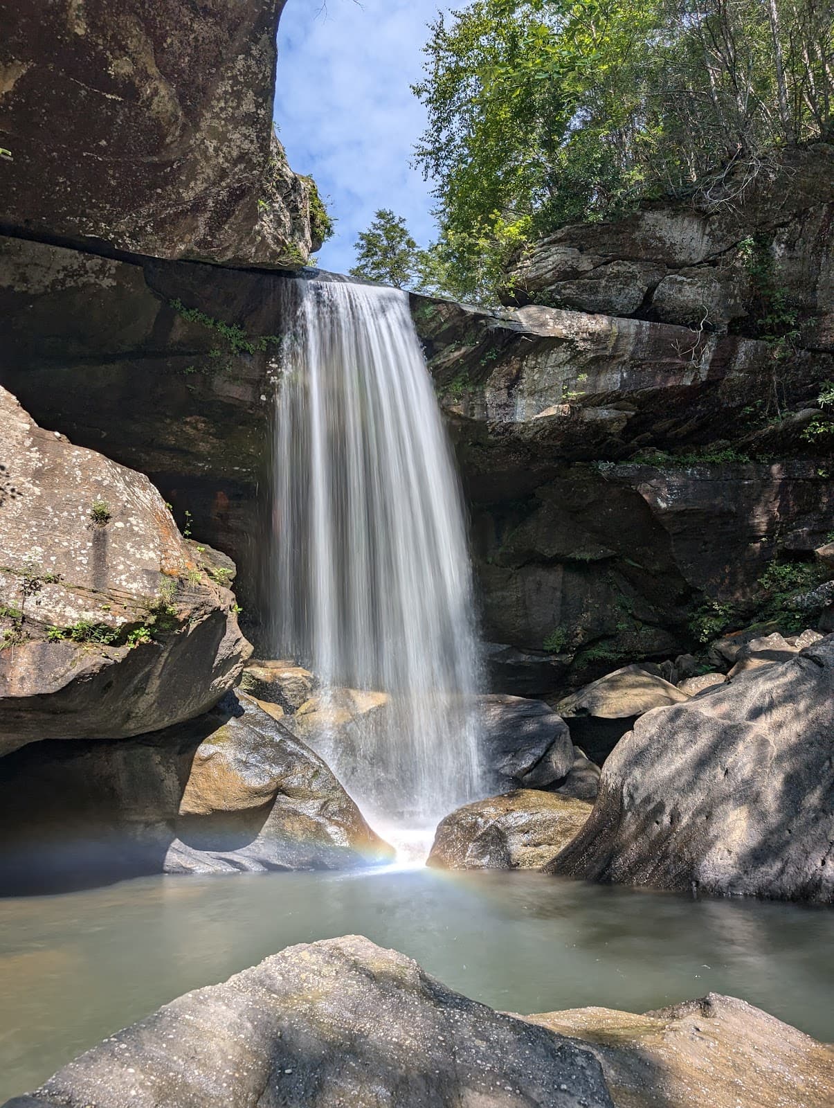
The trail offers stunning natural beauty, from the unique rock formations and caves like Resurgence Cave to the lush forests and scenic overlooks. The suspension bridge and Jumping Rock also make for dramatic shots. +2
Golden hours, shortly after sunrise and before sunset, will provide the best light for landscape photography, highlighting the textures and colors of the forest and rock formations. Midday sun can be harsh.
While not always marked, keep an eye out for natural clearings and higher elevations that offer panoramic views of the surrounding Daniel Boone National Forest. The areas around Jumping Rock and the suspension bridge are also visually striking.
Given the rugged terrain, lightweight and durable gear is recommended. A wide-angle lens is great for landscapes, while a telephoto lens can be useful for wildlife. A sturdy tripod can help with low-light conditions.
Include elements of scale in your photos, such as people, trees, or the suspension bridge, to convey the vastness of the landscape. Wide-angle shots can emphasize the expansive forests and dramatic rock features.
For Different Travelers
Tailored advice for your travel style
👨👩👧 Families with Kids
Tips for families:
* Choose shorter day hikes: Focus on sections with clear destinations or loop trails.
* Pack for comfort: Bring extra layers, rain gear, and plenty of snacks.
* Engage their curiosity: Turn the hike into a nature scavenger hunt or a geology lesson.
* Prioritize safety: Ensure children are supervised at all times, especially near water or steep drop-offs.
🎒 Budget Backpackers
Budget-friendly tips:
* Utilize dispersed camping: Camp away from developed sites to avoid fees.
* Pack your own meals: Avoid eating out by preparing your own trail food.
* Carpool or use public transport: If possible, share rides to trailheads to reduce fuel costs.
* Borrow or rent gear: If you're new to backpacking, consider borrowing or renting expensive equipment before investing.
📸 Photography Enthusiasts
To make the most of your photographic endeavors, aim for the golden hours around sunrise and sunset for the best light.
Deep Dives
In-depth insights and expert knowledge
Thru-Hiking the Sheltowee Trace Trail
Key considerations for thru-hiking include:
* Seasonality: Spring and fall offer milder temperatures, but can also bring rain and mud. Summer can be hot and humid, while winter presents its own set of challenges.
* Navigation: A reliable map and compass or GPS device are essential, as cell service is often spotty.
* Gear: Lightweight, durable gear is paramount. This includes a good backpack, tent, sleeping bag, and cooking system.
* Physical Fitness: Train rigorously to prepare for the demanding terrain and long mileage days.
* Resupply: Strategically plan where and when you will resupply food and other necessities.
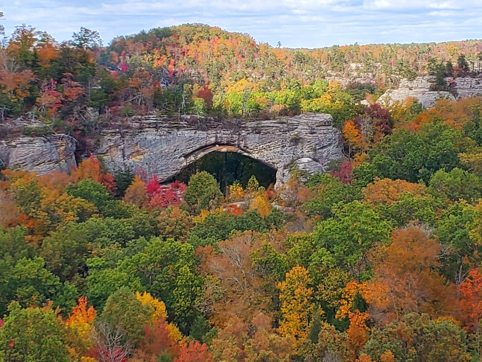
Exploring the Red River Gorge Section
Within the Red River Gorge area, you'll find iconic spots like the suspension bridge and Jumping Rock, which are popular landmarks for hikers.
Highlights of the Red River Gorge section:
* Natural Arches: The gorge is famous for its numerous natural sandstone arches.
* Cliffs and Overlooks: Dramatic cliff faces offer stunning panoramic views of the surrounding wilderness.
* Unique Flora: Dense forests with a rich diversity of plant life.
* Proximity to Amenities: Access to services like those at Miguel's can be a significant advantage for hikers.
Conservation and Trail Challenges
Beyond conservation efforts, hikers often encounter practical challenges on the trail. Limited parking at trailheads is a recurring issue, with some users reporting significant difficulties finding a place to leave their vehicles.


Social
from TikTok, Instagram & Reddit