
Arthur Ravenel Jr. Bridge
Iconic cable-stayed bridge with striking diamond towers, offering a 2.5-mile pedestrian path with stunning Charleston harbor views.

Highlights
Must-see attractions

Social
From TikTok & Reddit
Best Time
Fewer crowds, peaceful strolls
Arthur Ravenel Jr. Bridge
Best Time
Fewer crowds, peaceful strolls
Highlights
Must-see attractions
Iconic cable-stayed bridge with striking diamond towers, offering a 2.5-mile pedestrian path with stunning Charleston harbor views.
"A brilliant design which stands out in the distance of the Charleston skyline."

🚶♀️ Walk the Full Length
Don't miss the 2.5-mile pedestrian path for incredible views! :athletic_shoe:
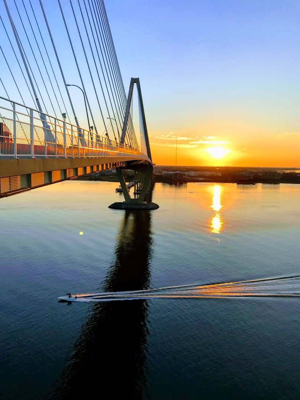
🌅 Catch a Stunning Sunset
The bridge offers prime sunset viewing over the Cooper River. :camerawithflash:

Highlights
Discover the most iconic attractions and experiences
Iconic Diamond Towers
Visible from afar
The bridge's distinctive diamond-shaped towers are a marvel of engineering and a symbol of Charleston's skyline.
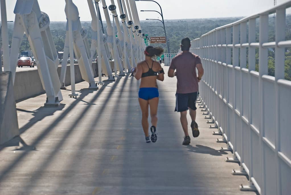
Pedestrian and Bike Path
Full length of the bridge
Stroll, jog, or cycle the 2.5 miles for breathtaking harbor and city views. A truly unique way to experience the bridge.

Sunset Spectacle
Western-facing viewpoints
Witness the sky ablaze with color as the sun dips below the horizon, reflecting beautifully on the Cooper River.
Plans like a pro.
Thinks like you
Planning Your Visit
Timing Your Visit for the Best Experience
Safety and Accessibility on the Bridge
Best Times
Insider Tips
from TikTok, Instagram & Reddit
🚶♀️ Walk the Full Length
Don't miss the 2.5-mile pedestrian path for incredible views! :athletic_shoe:
🌅 Catch a Stunning Sunset
The bridge offers prime sunset viewing over the Cooper River. :camerawithflash:
🏃♀️ Early Bird Gets the View
Beat the crowds by visiting early morning for a peaceful run or walk. :sunrise:
🚗 Parking Tips
Park in Mount Pleasant or downtown Charleston for easy access to the bridge paths. :parking:
Tips
from all over the internet
🚶♀️ Walk the Full Length
Don't miss the 2.5-mile pedestrian path for incredible views! :athletic_shoe:
🌅 Catch a Stunning Sunset
The bridge offers prime sunset viewing over the Cooper River. :camerawithflash:
🏃♀️ Early Bird Gets the View
Beat the crowds by visiting early morning for a peaceful run or walk. :sunrise:
🚗 Parking Tips
Park in Mount Pleasant or downtown Charleston for easy access to the bridge paths. :parking:
💡 Bridge Illumination
The bridge's lights at night create a magical atmosphere. :sparkles:
What Travellers Say
Reviews Summary
Visitors rave about the Arthur Ravenel Jr. Bridge's stunning design and the incredible experience of walking or cycling its 2.5-mile path. The panoramic views of Charleston and the harbor are consistently praised, making it a must-do activity. While generally a positive experience, some note the potential for crowds during peak times.
"Brilliant design which stands out in the distance of the Charleston skyline. However, what makes this bridge really unique is the public footpath for walking, running and cycling. Well worth a jog over."
Carlos Uploads
"Beautiful designed bridge that connects Charleston to Mt. Pleasant. There’s a walk path that goes the length of the bridge. Best part is no toll."
Andrew Izzo
"My wife and i decided to walk across the bridge early Friday morning. What a fun and enjoyable walk. The temperature was a little cool in the morning but once we got our heart rate up we were fine.
We were greeted by pretty much everyone we came across with much friendliness."
Richard Keith
What People Like
What People Dislike
Frequently Asked Questions
🚇 🗺️ Getting There
You can access the bridge from both Charleston and Mount Pleasant. Parking is available on both sides, with popular spots near Waterfront Park in Charleston and in Mount Pleasant. Many visitors enjoy walking or biking to the bridge from nearby attractions.
Yes, there are parking areas on both the Charleston and Mount Pleasant sides. Downtown Charleston offers street parking and garages, while Mount Pleasant has dedicated lots near the bridge entrance.
While direct public transport to the bridge itself is limited, you can take buses to downtown Charleston or Mount Pleasant and then walk or bike to the bridge access points. Check local transit schedules for routes.
Yes, the Arthur Ravenel Jr. Bridge is a major vehicular artery connecting Charleston and Mount Pleasant. However, the pedestrian and bike path is separate from the car lanes.
The pedestrian path has multiple access points on both sides. On the Charleston side, access is often from East Bay Street. On the Mount Pleasant side, you can find entrances near Patriots Point.
🎫 🎫 Tickets & Entry
No, walking, running, and cycling on the pedestrian path of the Arthur Ravenel Jr. Bridge is completely free. There are no tickets or admission fees required.
The pedestrian path is generally open 24/7, allowing for early morning runs or late-night strolls. However, it's always a good idea to check for any temporary closures or maintenance schedules.
There is no toll to drive or walk across the Arthur Ravenel Jr. Bridge. This is a significant benefit for visitors and locals alike.
While not explicitly stated in all sources, it's generally recommended to check local regulations for pets on public walkways. Many visitors do bring their dogs, but keeping them leashed is advised.
Cyclists share the path with pedestrians, so it's important to be courteous and mindful of others. Ride at a safe speed and yield to pedestrians.
🎫 🚶♀️ Onsite Experience
The bridge is approximately 2.5 miles long one way. Walking the entire length and back can take about 1 to 1.5 hours, depending on your pace and how often you stop for photos.
You'll get panoramic views of the Charleston harbor, downtown Charleston skyline, Fort Sumter, and the Cooper River. The views are spectacular in both directions.
The bridge is illuminated at night, offering a unique experience. However, for solo female travelers, sticking to daylight hours might be preferable for general safety.
Restrooms and water fountains are not typically available directly on the bridge itself. It's advisable to use facilities before you start your walk or at either end.
Comfortable walking shoes are a must! Dress in layers as the weather can change, and bring sunscreen and a hat, especially during warmer months. +1
📸 📸 Photography
Sunrise and sunset offer the most dramatic lighting for photography. The bridge's illuminated towers at night also provide stunning photo opportunities. +1
You can capture wide-angle shots of the Charleston skyline, close-ups of the bridge's unique architecture, and scenic views of the Cooper River and harbor. +1
Drone usage regulations can be complex and vary by location. It's best to check with local authorities or the FAA for current rules regarding drone operation near the bridge and Charleston airspace.
A wide-angle lens is great for capturing the expansive views, while a telephoto lens can be useful for details of the city or distant landmarks. A tripod can be helpful for low-light or long-exposure shots.
From Waterfront Park in Charleston, Patriots Point in Mount Pleasant, or even from a boat on the Cooper River, you can get fantastic perspectives of the bridge's iconic design.
For Different Travelers
Tailored advice for your travel style
👨👩👧 Families with Kids
Consider starting from the Mount Pleasant side, which often has easier parking and a more direct approach to the main pedestrian walkway. The length of the bridge (2.5 miles one way) can be a bit much for very young children, so a stroller or a plan to turn back halfway might be wise. The novelty of being on such a grand structure is usually enough to keep them entertained!
🏃♀️ Fitness Enthusiasts
Early mornings are ideal for avoiding crowds and enjoying cooler temperatures, especially during Charleston's warmer months. You'll find plenty of other fitness enthusiasts out and about, creating a motivating atmosphere. The panoramic views serve as a constant reward for your efforts.
📸 Photographers and View Seekers
Bring your wide-angle lens to capture the grandeur of the bridge and its surroundings, or a telephoto lens to focus on distant landmarks like Fort Sumter. The bridge's illumination at night also provides a unique backdrop for evening shots. Don't forget to explore viewpoints from both the Charleston and Mount Pleasant sides for diverse perspectives.
Deep Dives
In-depth insights and expert knowledge
The Engineering Marvel: Design and Construction
The construction itself was a monumental undertaking, involving complex techniques to build the towers and suspend the roadway. The bridge's cable-stayed design allows for a wide, unobstructed channel beneath, essential for maritime traffic in the Charleston Harbor. Its length of approximately 2.5 miles makes it one of the longest cable-stayed bridges in North America, offering a truly impressive scale.
Beyond its engineering prowess, the bridge was designed with public access in mind. The inclusion of a wide pedestrian and bicycle path was a deliberate choice to encourage recreation and provide a unique vantage point for experiencing the city and harbor. This feature has made it a beloved spot for locals and tourists alike, transforming it from a mere transportation route into a destination in itself.
Experiencing the Bridge: Walking, Running, and Cycling
Many visitors describe the experience as invigorating, with constant, breathtaking views. You'll see the Charleston skyline, historic Fort Sumter, and the bustling harbor. The path is wide enough to accommodate walkers, runners, and cyclists comfortably, though it's always wise to be mindful of others, especially during peak times. Early mornings are often recommended for a more tranquil experience, allowing you to truly soak in the atmosphere.
For those seeking a unique perspective, consider visiting during sunrise or sunset. The way the light plays off the water and the bridge's structure is magical. Some even combine their bridge visit with a meal at a nearby restaurant that offers bridge views, like Island Cabana Bar, turning it into a full Charleston experience.
The Bridge as a Charleston Icon
Beyond its visual appeal, the bridge has fostered a sense of community and shared experience. The pedestrian path encourages people to get out, be active, and connect with their surroundings. It's a place where locals go for their daily exercise, where families take leisurely strolls, and where visitors capture memorable photos. The bridge is more than just infrastructure; it's a gathering place.
Its presence has also influenced the surrounding areas, with businesses and parks on both sides benefiting from the increased foot traffic and visibility. The bridge is a testament to thoughtful urban planning, integrating a vital transportation link with a valuable recreational amenity that enhances the quality of life in the Lowcountry.


Social
from TikTok, Instagram & Reddit