Pico Gilillo
Conquer Pico Gilillo, the highest peak in Cazorla, for breathtaking panoramic views and a challenging, rewarding mountain adventure.
Highlights
Must-see attractions

Social
From TikTok & Reddit
Best Time
Ideal weather for hiking
Pico Gilillo
Best Time
Ideal weather for hiking
Highlights
Must-see attractions
Conquer Pico Gilillo, the highest peak in Cazorla, for breathtaking panoramic views and a challenging, rewarding mountain adventure.
"The views from the trig point will leave you speechless; it's worth the challenging climb!"

GPS is Your Friend
Trail can be poorly marked; a GPS device or app is highly recommended for navigation. :iphone:
Allow Ample Time
Plan for 6+ hours round trip, including stops for photos and rest. :clock:

Highlights
Discover the most iconic attractions and experiences
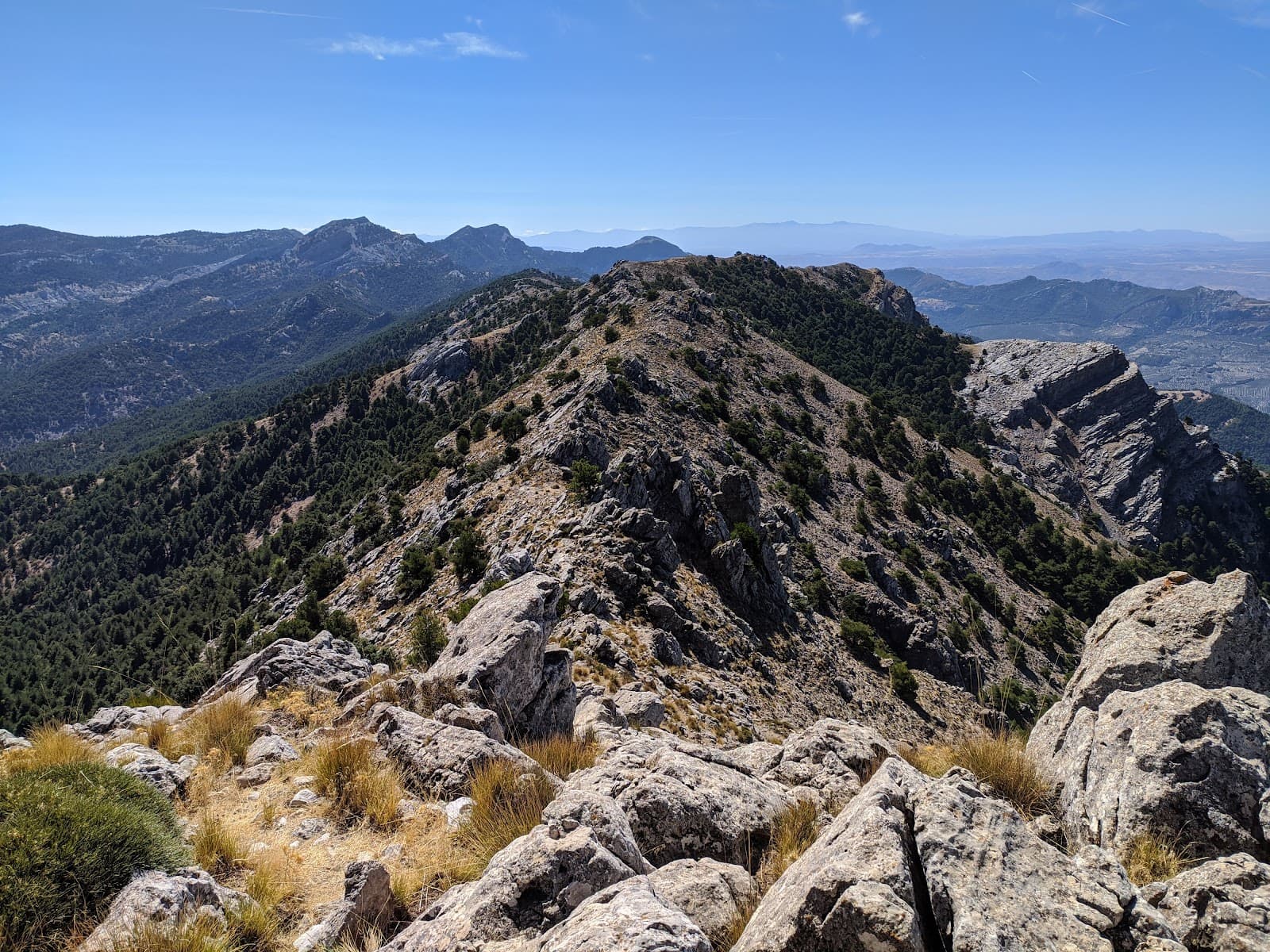
Pico Gilillo Summit
Summit
Reach the highest point in the Cazorla range for unparalleled 360-degree views of the surrounding natural park.
Geodesic Vertex
Summit
Find the trigonometric point at the summit, a marker of your achievement and a great photo opportunity.

Scenic Trail Ascent
Various trails from Cazorla or El Chorro
Experience the beauty of the Sierra de Cazorla as you ascend through diverse landscapes.
Plans like a pro.
Thinks like you
Planning Your Visit
Tackle the Trail Wisely
Summit Views & Safety
Best Times
Insider Tips
from TikTok, Instagram & Reddit
GPS is Your Friend
Trail can be poorly marked; a GPS device or app is highly recommended for navigation. :iphone:
Allow Ample Time
Plan for 6+ hours round trip, including stops for photos and rest. :clock:
Tackle the Final Climb
The last section to the summit is tricky; proceed with caution, especially in adverse weather. :hiking_boot:
Pack Essentials
Bring plenty of water, snacks, and sun protection for this demanding hike. :water_wave:
Tips
from all over the internet
GPS is Your Friend
Trail can be poorly marked; a GPS device or app is highly recommended for navigation. :iphone:
Allow Ample Time
Plan for 6+ hours round trip, including stops for photos and rest. :clock:
Tackle the Final Climb
The last section to the summit is tricky; proceed with caution, especially in adverse weather. :hiking_boot:
Pack Essentials
Bring plenty of water, snacks, and sun protection for this demanding hike. :water_wave:
Leave No Trace
Help preserve the natural beauty by taking all your trash with you. :recycle:
What Travellers Say
Reviews Summary
Pico Gilillo is celebrated for its spectacular summit views and challenging, rewarding hike through the Sierra de Cazorla. While the ascent is demanding and trail marking can be inconsistent, the panoramic vistas make the effort worthwhile for experienced hikers and trail runners. Caution is advised on the final summit approach, especially in adverse weather.
"Gilillo is one of the Sierra's iconic peaks, with a considerable elevation gain from Cazorla or El Chorro. The climb is also possible from Montesión. The trail is generally well-marked; it's a Mackay path or one from his time, which connected various forestry lodges. You have to find it, and it takes you to the Gilillo Pass. Then you have to find the path to the summit, where you'll find a geodesic vertex. This last section is poorly defined and is the most difficult, requiring more ingenuity and skill, but it's worth doing for the fabulous views from there."
Juan de la Cruz Moreno Balboa
"Poco Gilillo, at 1,848 meters, is the highest peak in the Cazorla mountain range. It's worth the climb to see the views. Excellent, it's worth it."
Julio Angel Delgado Navas
"Spectacular!
We started the route from the town of Cazorla. It's a fairly long and poorly marked route, so I recommend using a GPS, preferably one specialized in trails of this type.
The views as you climb are incredible, but when you reach the trig point, you'll be speechless.
It took us about 6 hours or more, round trip with many stops."
Encarni B.
What People Like
What People Dislike
Frequently Asked Questions
🚇 🗺️ Getting There
Pico Gilillo can be accessed from several points, including Cazorla and El Chorro. The route from Cazorla is popular but can be long and poorly marked, making a GPS essential. Some trails follow old Mackay paths connecting forestry lodges.
Common starting points include the town of Cazorla or the Escaleruela. Some routes also begin near the ermita de la Virgen de la Cabeza. +1
Information on direct public transport to specific trailheads is limited. It's advisable to check local bus schedules for Cazorla and consider local taxi services or organized tours if you don't have a car.
You can drive to Cazorla and potentially to trail access points like El Chorro. Parking availability can vary, especially during peak seasons.
Roads leading to Cazorla are generally good. However, some access tracks to trailheads might be unpaved or rough, requiring a suitable vehicle.
🎫 🎫 Tickets & Entry
Pico Gilillo is located within the Sierra de Cazorla, Segura y Las Villas Natural Park, which generally does not require an entrance fee for hiking. However, always check for any specific park regulations or access restrictions.
There are typically no direct fees for hiking Pico Gilillo itself. However, if you opt for guided tours or activities, these will have associated costs.
As a natural park, access is generally open year-round. However, specific visitor centers or facilities within the park may have operating hours.
Yes, several local guides and adventure companies offer guided ascents of Pico Gilillo, which can be beneficial for navigation and safety.
For standard day hiking, permits are generally not required. However, for specific activities like camping or if you plan to explore off-trail in sensitive areas, it's wise to inquire with park authorities.
🎫 🥾 Onsite Experience
The hike to Pico Gilillo is considered difficult due to significant elevation gain and a challenging final ascent to the summit. It's recommended for experienced hikers.
A round trip hike can take approximately 6 hours or more, depending on your pace, the route taken, and the number of stops for rest and photos.
The terrain varies from forest paths and old tracks to rocky and steep sections, especially on the final approach to the summit.
Facilities are scarce on the trail itself. It's crucial to carry all necessary water and supplies. There might be some facilities in Cazorla before you start your hike.
Yes, Pico Gilillo is a popular destination for trail running, with some routes covering significant distances and elevation.
📸 📸 Photography
The summit offers spectacular panoramic views of the Sierra de Cazorla. The journey itself also presents beautiful landscapes, including forests and mountain vistas.
Sunrise and sunset can offer dramatic lighting, but clear midday conditions provide the best visibility for capturing the expansive views.
A wide-angle lens is great for capturing the sweeping landscapes. Consider a telephoto lens for details of distant peaks or wildlife. A sturdy tripod can be useful for low-light conditions. :camerawithflash:
The summit itself is the primary viewpoint. Along the ascent, keep an eye out for clearings that offer different perspectives of the surrounding mountains and valleys.
Drone usage in natural parks often has restrictions. It's essential to check the regulations of the Sierra de Cazorla, Segura y Las Villas Natural Park regarding drone operation before flying.
For Different Travelers
Tailored advice for your travel style
👨👩👧 Families with Kids
🏃♀️ Trail Runners
⛰️ Experienced Hikers
Deep Dives
In-depth insights and expert knowledge
Navigating the Trails
While some parts of the trail are relatively straightforward, the final approach to the summit is described as the most difficult and requires more ingenuity and skill.
For those seeking a guided experience, several local operators offer guided ascents, which can provide valuable insights into the terrain and ensure better navigation.
The Reward: Summit Views
As you ascend, the scenery unfolds, revealing diverse landscapes of forests, rugged mountains, and distant valleys.
For the best photographic opportunities, consider visiting during sunrise or sunset for dramatic lighting, or opt for a clear midday for maximum visibility of the expansive panoramas.


Social
from TikTok, Instagram & Reddit