
Fort Nottingham Nature Reserve
Discover the tranquil beauty of Fort Nottingham Nature Reserve, a free natural escape with the rewarding Tony Kerr Trail and diverse flora.
Highlights
Must-see attractions

Social
From TikTok & Reddit
Best Time
Cooler temps, better light for photos
Fort Nottingham Nature Reserve
Best Time
Cooler temps, better light for photos
Highlights
Must-see attractions
Discover the tranquil beauty of Fort Nottingham Nature Reserve, a free natural escape with the rewarding Tony Kerr Trail and diverse flora.
"A hidden gem with a rewarding trail, perfect for a peaceful nature escape."
🎯 Find the Hidden Entrance
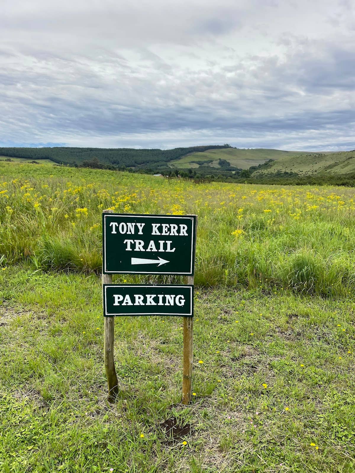
Look for a signpost in a large meadow & follow the mown path to parking. Coordinates: S 29.416184 E 29.915160.
🚶♀️ Bring a Walking Stick
Essential for clearing spiderwebs and navigating steep, damp sections of the Tony Kerr Trail.
Highlights
Discover the most iconic attractions and experiences
Tony Kerr Trail
Fort Nottingham Nature Reserve
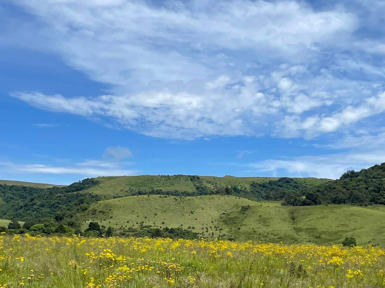
A 2km loop through diverse flora, from lichen-covered shrubs to dense forests with ravines. Well-signposted and rewarding.
Picnic & Braai Area
Trailhead
A serene spot to relax and enjoy nature after your hike. Offers a tranquil ambiance and picturesque surroundings.
Birding Opportunities
Throughout the reserve
Enjoy birdwatching amidst the varied habitats, from open meadows to dense woodlands. A peaceful escape for nature lovers.
Plans like a pro.
Thinks like you
Planning Your Visit
Finding the Trailhead
Trail Preparedness
Best Times
Insider Tips
from TikTok, Instagram & Reddit
🎯 Find the Hidden Entrance
Look for a signpost in a large meadow & follow the mown path to parking. Coordinates: S 29.416184 E 29.915160.
🚶♀️ Bring a Walking Stick
Essential for clearing spiderwebs and navigating steep, damp sections of the Tony Kerr Trail.
🌳 Enjoy the Diverse Flora
The trail showcases lichen-covered shrubs, tall trees, and ravines. Tree species are often labeled.
🧺 Pack a Picnic
The picnic/braai area is a lovely spot to refuel and soak in the serene atmosphere.
Tips
from all over the internet
🎯 Find the Hidden Entrance
Look for a signpost in a large meadow & follow the mown path to parking. Coordinates: S 29.416184 E 29.915160.
🚶♀️ Bring a Walking Stick
Essential for clearing spiderwebs and navigating steep, damp sections of the Tony Kerr Trail.
🌳 Enjoy the Diverse Flora
The trail showcases lichen-covered shrubs, tall trees, and ravines. Tree species are often labeled.
🧺 Pack a Picnic
The picnic/braai area is a lovely spot to refuel and soak in the serene atmosphere.
🚗 Dirt Road Drive
The drive to the reserve offers an enjoyable experience on dirt roads.
What Travellers Say
Reviews Summary
Visitors praise Fort Nottingham Nature Reserve for its free entry, serene atmosphere, and the rewarding Tony Kerr Trail. The diverse flora and birding opportunities are highlights, though finding the trailhead can be a minor challenge. The dirt roads add to the rustic charm.
"Free entry! There are no signs to the parking but you just turn in off the main road, follow the track as it turns right, then left, then left and voila there is the parking and picnic site. The trail goes up the mountain from there. It turns out that this nature reserve was the commonage of the old Fort Nottingham when it ceased to be a military outpost. Enjoyed birding there."
Alan Heathcote
"Fort Nottingham Nature Reserve is an exceptionally picturesque location that is characterized by its serene and tranquil ambiance. Aside from the hiking trail, it's also a nice picnic spot. The dirt roads provide an enjoyable driving experience."
काश्वीर
"We discovered the wooded hillside of the Fort Nottingham Nature Reserve by walking the 'Tony Kerr Trail'.
Picking up the trail is the first challenge, because it's not obvious from the road! There is a signpost standing within a very large meadow, indicating a mown pathway to the right. If you follow this pathway, you will eventually reach the start of the trail, with a parking and picnic/braai area.
Exact coordinates of the trail start are:
South 29.416184 East 29.915160.
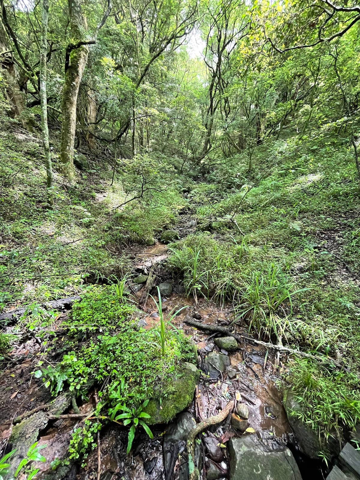
The trail leads into an area of shrubs and low trees, heavy with lichen and moss. Harmless spiders tend to throw their webs across the trail, so a walking stick (to break the webs) will be very handy! If the ground is damp, the stick will be doubly useful on the steep sections.
The trail forks exactly at these co-ordinates:
South 29.414613. East 29.914966
Take the right turn at this fork, and then follow the signs depicting a Chameleon. There are plenty of these signs along the trail, which follows a large loop and returns to the point where it forked. (There are also plenty of labels that name the species of tree on which they're found).
The trail gains elevation and moves into different topography and flora. The lichen-covered shrubs at lower elevation give way to tall, majestic trees in a darker, denser and more steeply sloped forest, with ravines cut by several streams.
Eventually you will return to the fork, and retrace your footsteps from that point back to the picnic/braai area.
The whole walk is perhaps 2km long, but slow-going due to the steep terrain.
For some extra walking, park where you see the first sign for the Nature Reserve, and walk the mowed pathway through the meadow. It's beautiful, and far less demanding than the forest and slopes."
Andrew Quixley
What People Like
What People Dislike
Frequently Asked Questions
🚇 🗺️ Getting There
The parking isn't obvious. Look for a signpost in a large meadow and follow the mown pathway to the right. The parking and picnic area is at the end of this path. Exact coordinates for the trail start are South 29.416184, East 29.915160.
The roads leading to the reserve are dirt roads, which many visitors find to be an enjoyable driving experience.
Yes, the dirt roads provide an enjoyable driving experience. The road to the trail itself can be overgrown but navigable.
The best way to access the Tony Kerr Trail is by finding the signpost in the large meadow and following the mown pathway. This leads to the parking and picnic area, which is the start of the trail.
While there isn't a clear sign from the main road, using GPS coordinates for the trail start (South 29.416184, East 29.915160) can be very helpful in locating the parking area.
🎫 🎫 Tickets & Entry
No, Fort Nottingham Nature Reserve offers free entry, making it an accessible natural escape.
Specific opening hours are not widely published, but it's generally accessible during daylight hours. It's best to visit during the day for safety and enjoyment.
No advance booking is required as entry is free. You can visit spontaneously during daylight hours.
There is no formal visitor center mentioned. The reserve is more of a natural area with marked trails and a picnic spot.
The main facilities available are a parking area and a picnic/braai site located near the trailhead.
🎫 🏞️ Onsite Experience
The Tony Kerr Trail is a loop of about 2km, winding through diverse landscapes. It starts in shrubland and ascends into a denser forest with streams and ravines. It can be steep and damp.
Yes, the trail is generally well-signposted, with signs depicting a Chameleon and labels for tree species.
Expect varied terrain, including steep sections, damp ground, and uneven paths. A walking stick is recommended for stability and clearing spiderwebs.
The trail features a fork where you should take the right turn, following Chameleon signs. It also passes through areas with labeled tree species.
Yes, visitors have enjoyed birding at Fort Nottingham Nature Reserve, appreciating the tranquil ambiance and diverse habitats.
📸 📸 Photography
Capture the lichen-covered shrubs, the dense, majestic trees in the forest, and the scenic ravines. The mown pathway through the meadow also offers beautiful, less demanding photo ops.
Absolutely. The reserve offers diverse flora, from mossy shrubs to tall trees, and the tranquil atmosphere is perfect for capturing natural beauty.
Mornings often provide softer light and fewer crowds, ideal for capturing the details of the forest and the serene landscape.
While not explicitly marked as viewpoints, the higher elevations on the Tony Kerr Trail offer glimpses into the forest and ravines, providing scenic photo opportunities.
A wide-angle lens can be useful for capturing the forest canopy and landscapes, while a macro lens might be good for the intricate details of lichen and flora.
For Different Travelers
Tailored advice for your travel style
👨👩👧 Families with Kids
For families with slightly older children, the Tony Kerr Trail offers an adventure. While parts can be steep, the well-marked path and the novelty of spotting tree labels can keep kids engaged. Bringing a walking stick can add to the fun and provide a sense of preparedness. Ensure children wear appropriate footwear for the uneven terrain.
🚶♀️ Hikers and Nature Enthusiasts
Nature enthusiasts will appreciate the birding opportunities and the chance to observe various plant species, many of which are labeled along the trail. The tranquil ambiance of the reserve makes it an ideal location for quiet contemplation and immersion in the natural world. Remember to bring your camera to capture the unique flora and fauna.
Deep Dives
In-depth insights and expert knowledge
Navigating the Tony Kerr Trail
As the trail ascends, it transitions into a denser, darker forest characterized by tall, majestic trees and steep slopes cut by several streams and ravines. The terrain can become damp, especially after rain, so sturdy footwear is essential. The trail is marked with signs depicting a Chameleon and labels identifying various tree species, aiding navigation.
At a key fork in the path (coordinates South 29.414613, East 29.914966), visitors should take the right turn to continue the loop. The trail eventually returns to this fork, allowing hikers to retrace their steps back to the picnic area. For a less strenuous experience, walking the mown pathway through the meadow before reaching the main trail is also recommended.
The History and Ecology of Fort Nottingham
Ecologically, the reserve is a fascinating microcosm of the region's flora. The lower elevations are characterized by shrubs heavy with lichen and moss, creating an almost ethereal atmosphere. As the trail climbs, it enters a more traditional forest environment with tall trees, providing a habitat for diverse plant and animal life. The presence of streams and ravines further contributes to the varied topography and ecological richness of the area.


Social
from TikTok, Instagram & Reddit