Cerro de Punta Puerto Rico
Puerto Rico's highest peak, offering dramatic island views after a challenging drive and steep hike.
Highlights
Must-see attractions

Social
From TikTok & Reddit
Best Time
Clear views, less chance of storms
Cerro de Punta Puerto Rico
Best Time
Clear views, less chance of storms
Highlights
Must-see attractions
Puerto Rico's highest peak, offering dramatic island views after a challenging drive and steep hike.
"The views are breathtaking and it is definitely worth the drive and the hike. "
🚗 4x4 Recommended, but Hike!
A 4x4 is best for the road, but be prepared to hike the last part. Don't trust GPS blindly!
☀️ Go Early for Views
Morning offers the clearest views. Afternoon storms can quickly obscure the scenery.

Quick Facts
Rating
4.7 · 203 reviews
Type
Mountain Peak
Highlights
Discover the most iconic attractions and experiences
The Summit View
Cerro de Punta Peak
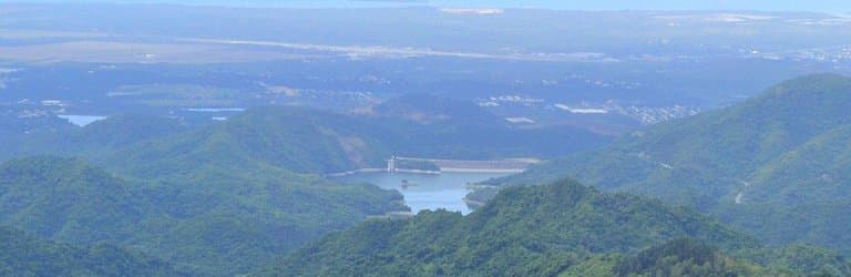
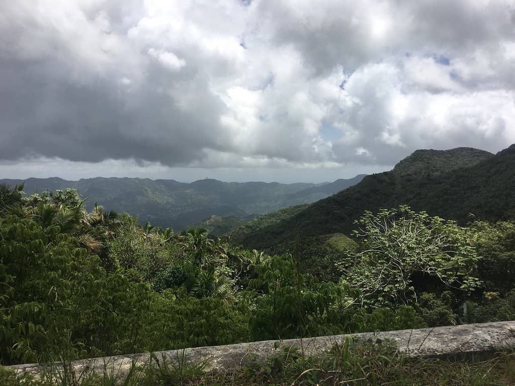
Panoramic vistas stretching across Puerto Rico, offering a unique perspective of the island's diverse landscapes.

The Challenging Drive
Road to Cerro de Punta
An adventurous journey up steep, rugged terrain that tests your vehicle and your nerve, rewarding you with stunning scenery.

The Final Hike
Trail to the peak
A steep, approximately 0.8-mile hike from the parking area to the summit, offering a rewarding physical challenge.
Plans like a pro.
Thinks like you
Planning Your Visit
Navigating the Ascent
Weather Watch
Best Times
Insider Tips
from TikTok, Instagram & Reddit
🚗 4x4 Recommended, but Hike!
A 4x4 is best for the road, but be prepared to hike the last part. Don't trust GPS blindly!
☀️ Go Early for Views
Morning offers the clearest views. Afternoon storms can quickly obscure the scenery.
🥾 Sturdy Hiking Shoes
The trail is steep and can be rocky. Comfortable, supportive footwear is essential.
🐝 Respect the Wildlife
Yellow jackets are present but generally leave you alone if undisturbed.
Tips
from all over the internet
🚗 4x4 Recommended, but Hike!
A 4x4 is best for the road, but be prepared to hike the last part. Don't trust GPS blindly!
☀️ Go Early for Views
Morning offers the clearest views. Afternoon storms can quickly obscure the scenery.
🥾 Sturdy Hiking Shoes
The trail is steep and can be rocky. Comfortable, supportive footwear is essential.
🐝 Respect the Wildlife
Yellow jackets are present but generally leave you alone if undisturbed.
🗺️ Know Your Route Back
Avoid getting lost on remote streets at night; plan your return journey carefully.
What Travellers Say
Reviews Summary
Visitors consistently praise the breathtaking, panoramic views from Cerro de Punta, calling it an amazing viewpoint for the island. The challenging drive and steep hike are seen as part of the adventure, with many agreeing the effort is well worth the reward. However, some find the road conditions difficult even for 4x4 vehicles, and weather can quickly obscure the scenery.
"Amazing viewpoint for the island.
The drive up if you attempt it from
Parking lot up is steep and has one chunky large loose rock section on a very steep grade, you’d be fine in a 4x4 with all terrain tires but road tires on our 4x4 spun out. You can walk up as well and the yellow jackets up top leave you alone if you don’t mess with them. Gorgeous views!! Best to go up early on a sunny day for the best views. Afternoon storms Can roll In and cloud you out quickly."
Nathan Duce
"One of the best hikes I’ve done in a while. There is a rugged parking lot at the base of the peak. The hike is about 0.8 miles one way. The trail has a high elevation gain and it is steep. The views are breathtaking and it is definitely worth the drive and the hike. One advise, make sure to know your way back home and do not trust Google Maps. I got stuck in dead end remote streets at night."
Daniel Czyz
"It’s approximately a 2 mile walk from the trailhead to the top and back. The view is beautiful and to me worth the steep walk. If you have a 4x4 car you might be able to take the car to the top but make sure you have good tires, there are some big holes and rocks on the way up. The road is in very bad conditions."
Maria Santiago
What People Like
What People Dislike
Frequently Asked Questions
🚇 🗺️ Getting There
The drive to Cerro de Punta involves navigating steep, unpaved roads with large rocks. While a 4x4 vehicle with good tires is recommended, many visitors find it necessary to park and hike the final section. It's crucial to be cautious and not solely rely on GPS, as it can lead to dead ends.
The road is largely unpaved and can be in very bad condition, with sections of rocks and washed-out areas. Some parts might have a smoother concrete path after the initial rough terrain, but a 4x4 is still advised.
It's possible to drive a significant portion of the way, and some with modified 4x4 vehicles might reach closer to the summit. However, even with a capable vehicle, you may need to hike the last kilometer or so.
While GPS can be a starting point, it's highly recommended to have a reliable map or local directions. Some travelers have reported getting stuck on dead-end remote streets when relying solely on navigation apps.
Cerro de Punta is shared between the municipalities of Ponce and Jayuya. The access road and trail can be approached from either direction, but the road conditions are a significant factor regardless of your starting point. +1
🎫 🎫 Tickets & Entry
There are no specific tickets required to visit Cerro de Punta. It's a natural peak accessible to the public, though the challenging road conditions and the hike are part of the experience.
Cerro de Punta does not have official operating hours as it is a natural landmark. However, it's best to visit during daylight hours for safety and to enjoy the views.
No, there is no entrance fee to access Cerro de Punta. The primary costs are associated with transportation and potentially vehicle wear and tear if you attempt the drive.
Yes, Cerro de Punta can be visited year-round. However, weather conditions, especially during hurricane season, can impact accessibility and visibility.
There is a parking area at the base of the peak, which serves as the trailhead for those who choose to hike the final ascent.
🎫 ⛰️ Onsite Experience
The hike from the parking lot to the summit is approximately 0.8 miles one way, making it about a 1.6-mile round trip. The trail is steep and challenging.
The views from the summit are breathtaking and panoramic, offering a unique perspective of the entire island. On clear days, you can see vast stretches of Puerto Rico.
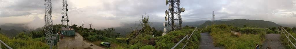
There are no significant facilities at the summit. You'll find communication towers, but no restrooms or visitor centers. It's important to come prepared.
Wear sturdy hiking shoes or boots due to the steep and rocky terrain. Comfortable clothing suitable for hiking and potentially cooler mountain temperatures is recommended.
While the views are spectacular, the challenging road and hike require caution. Be mindful of the terrain, weather, and your navigation. Respecting wildlife, like yellow jackets, is also advised.
📸 📸 Photography
The summit offers unparalleled panoramic views, perfect for landscape photography. The rugged road leading up also provides dramatic shots, especially with a capable vehicle.
Early mornings on a sunny day are ideal for photography, offering the clearest light and the best chance for unobstructed views.
While not explicitly prohibited, be mindful of any regulations regarding drone usage in natural areas and near communication towers. Always fly responsibly.
A wide-angle lens is great for capturing the expansive views. A sturdy tripod can be helpful for low-light conditions or capturing long exposures.
The communication towers themselves can create interesting foreground elements against the vast landscape. The challenging road also offers unique perspectives.


Social
from TikTok, Instagram & Reddit