São Lourenço Trail Quinta do Lago
A scenic 7km loop through diverse Algarve landscapes: salt marshes, Roman ruins, golf courses, and a beautiful beach.
Highlights
Must-see attractions

Social
From TikTok & Reddit
Best Time
Pleasant temperatures for hiking
São Lourenço Trail Quinta do Lago
Best Time
Pleasant temperatures for hiking
Highlights
Must-see attractions
A scenic 7km loop through diverse Algarve landscapes: salt marshes, Roman ruins, golf courses, and a beautiful beach.
"Beautifully varied landscapes between the golf course, lagoon, salt marshes and beach. A must-do if you are in the area."
Start at Golf Course Car Park
Easily access the trail by parking at the Golf Course car park. Follow signs for the beach and salt marshes. :car:
Wear Sturdy Footwear
The terrain varies from sandy paths to potentially boggy areas. Good walking shoes are essential. :athletic_shoe:
Highlights
Discover the most iconic attractions and experiences
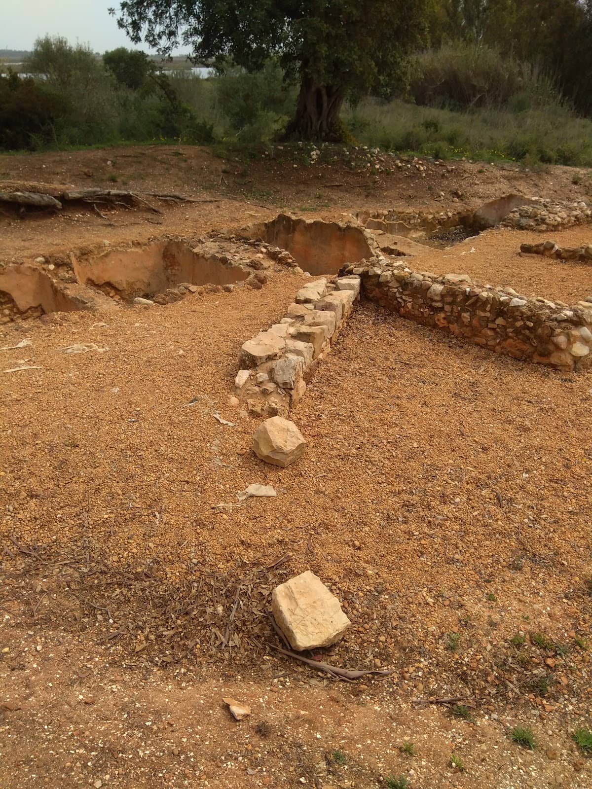
Roman Salt Pans
Along the trail
Discover ancient Roman salt pans, a testament to the area's historical significance and a unique sight on your hike.
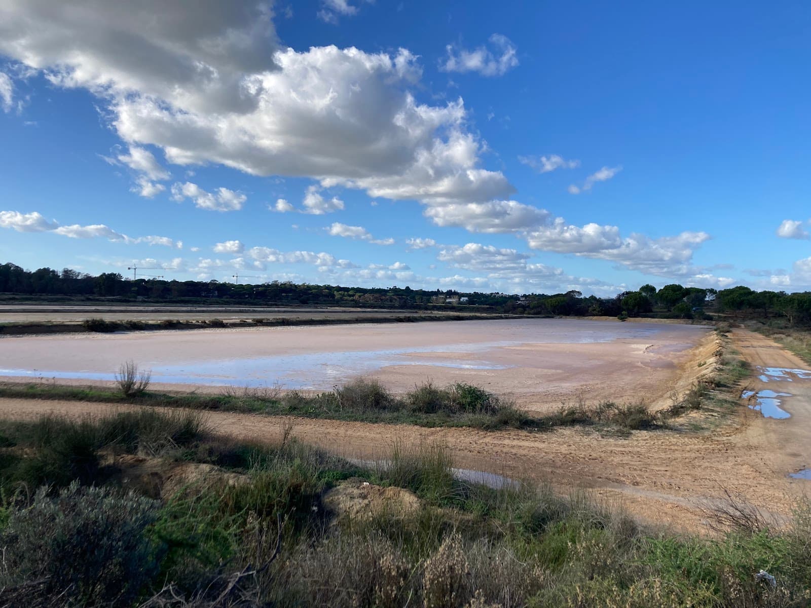
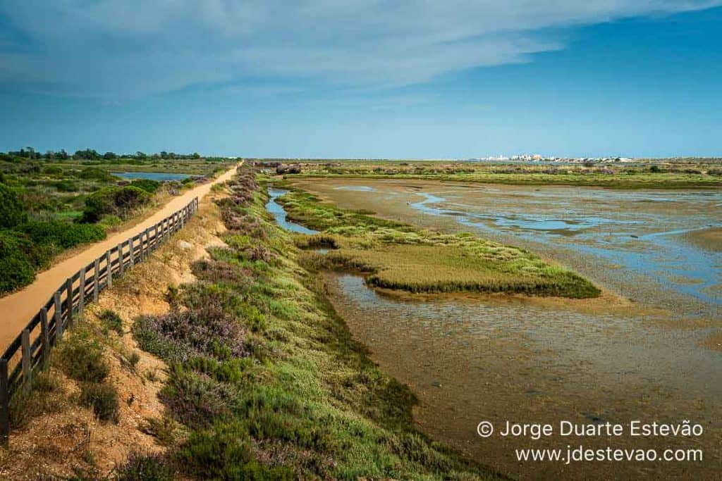
Varied Coastal Landscapes
Trail loop
Experience a stunning mix of golf courses, lagoons, salt marshes, and a beautiful beach, offering diverse scenery.

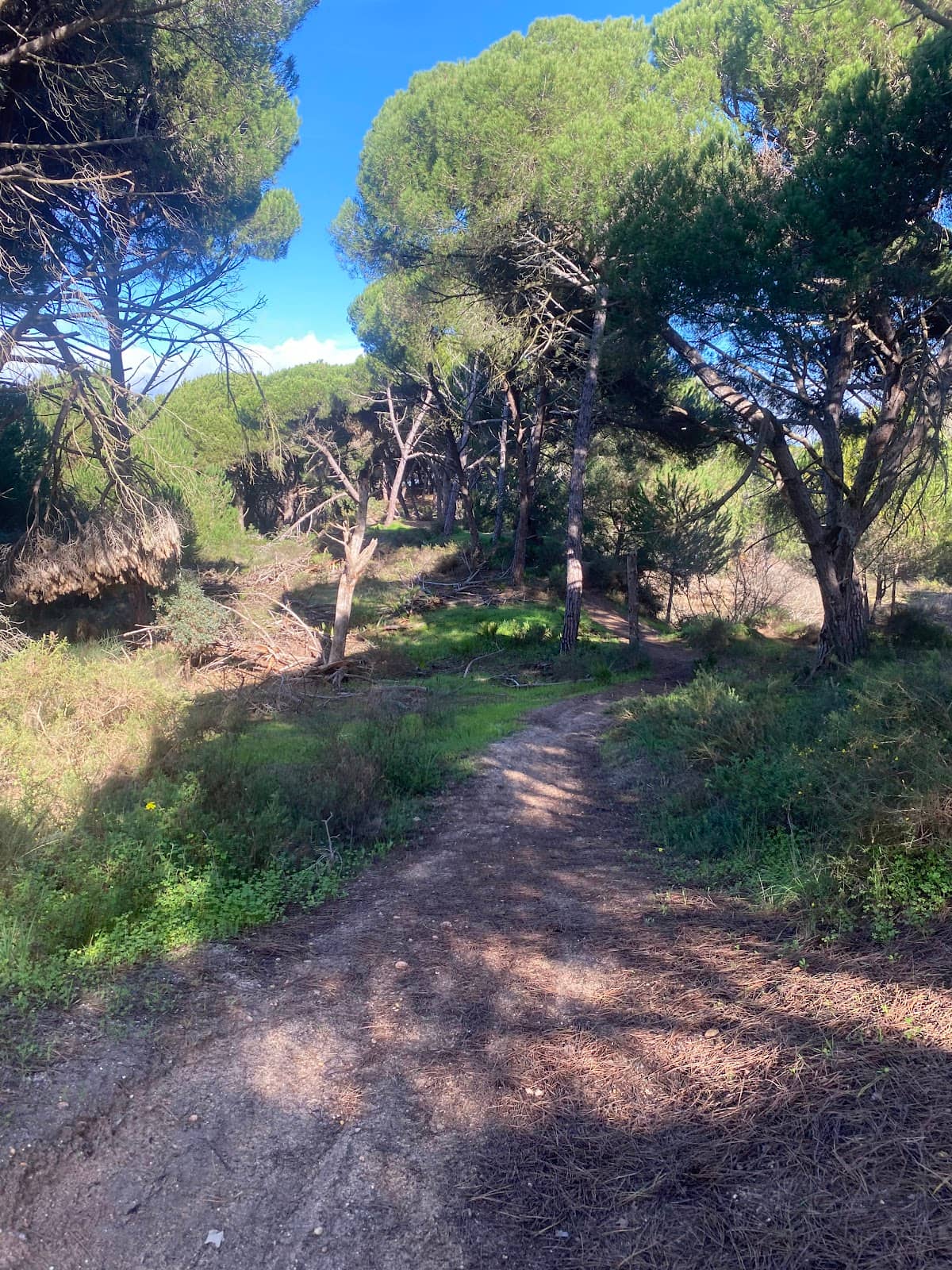
Eucalyptus Groves
Near salt marshes
Wander through fragrant eucalyptus trees, adding a sensory delight to the diverse terrain of the trail.
Plans like a pro.
Thinks like you
Planning Your Visit
Respect Private Land & Stay on Paths
Check Trail Conditions & Signage
Best Times
Insider Tips
from TikTok, Instagram & Reddit
Start at Golf Course Car Park
Easily access the trail by parking at the Golf Course car park. Follow signs for the beach and salt marshes. :car:
Wear Sturdy Footwear
The terrain varies from sandy paths to potentially boggy areas. Good walking shoes are essential. :athletic_shoe:
Be Prepared for Detours
Signage can be poor and some paths may be closed. Be ready to adapt your route. :warning:
Respect Private Property
Stick to marked paths and be considerate of surrounding lands, including golf courses and vineyards. :housewithgarden:
Tips
from all over the internet
Start at Golf Course Car Park
Easily access the trail by parking at the Golf Course car park. Follow signs for the beach and salt marshes. :car:
Wear Sturdy Footwear
The terrain varies from sandy paths to potentially boggy areas. Good walking shoes are essential. :athletic_shoe:
Be Prepared for Detours
Signage can be poor and some paths may be closed. Be ready to adapt your route. :warning:
Respect Private Property
Stick to marked paths and be considerate of surrounding lands, including golf courses and vineyards. :housewithgarden:
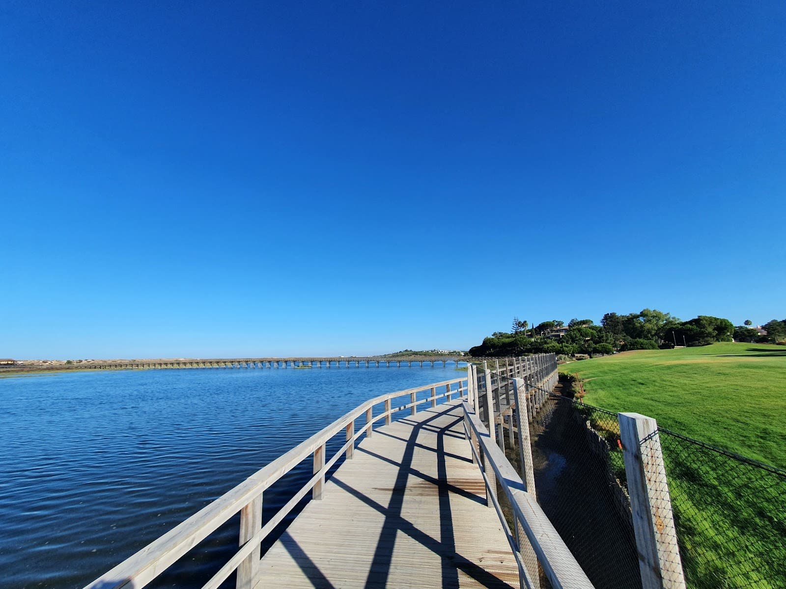
Approx. 7km Loop
The main circular route is around 7 km, offering a good half-day adventure. :hiking_boot:
What Travellers Say
Reviews Summary
Visitors praise the São Lourenço Trail for its stunningly varied landscapes, from salt marshes and lagoons to beaches and eucalyptus groves, offering a unique hiking experience. However, many note significant issues with poor signage and occasional trail closures, which can make navigation challenging and require adaptability. Despite these drawbacks, it's considered a must-do for its natural beauty and historical Roman salt pans.
"This is a beautiful place to walk and explore! Try to be considerate of people’s lands and stick to the paths when you feel suitable, I really enjoyed the variety of the terrain as hopefully shown by the pictures. It’s a great place to visit during the summer times but I’m not sure if it would be as easy to navigate in heavy rain! Can imagine it would get boggy. Would recommend to anyone visiting Faro or Nearby, I took the opportunity to walk around here shortly after landing from the Airport. Good way to get an adventure started, I did the hike alone for anyone curious."
Alex Whittaker
"Neste trilho existem tanque de salga romanos. Ótimo para correr ou pedalar. Infelizmente uma empresa meteu uma cerca entre o campo de golfe e as salinas, o motivo foi por terem suas obras embargadas pela justiça, por terem feito uma plantação de vinhas dentro do parque natural sem licença ambiental. Lembrem do nome da Herdade e evitem comprar tal vinho."
justiceiroverde
"Beautifully varied landscapes between the golf course, lagoon, salt marshes and beach. A must-do if you are in the area. Start from the Golf course car park: go to the beach opposite by taking the wooden footbridge then retrace your steps and take the path to the right. After about 1 or 2 km, turn left towards the salt marshes after a wooden bridge. You will walk along eucalyptus trees. At the end of the path, at the level of the salt mounds, turn left, the path retraces your steps along the golf course to the starting point. Distance approximately 7 km."
Angelique Leconte
What People Like
What People Dislike
Frequently Asked Questions
🚇 🗺️ Getting There
The most common starting point is the Golf Course car park at Quinta do Lago. From there, follow signs towards the beach and then the salt marshes to begin the loop. It's easily accessible by car if you're staying in the Algarve region.
Public transport options directly to the trail's starting point might be limited. It's often easier to reach Quinta do Lago via taxi or ride-sharing services from nearby towns like Faro or Albufeira.
Yes, you can drive or take a taxi from Faro to Quinta do Lago. The drive is relatively short, making it a feasible day trip.
While there are some signs, they can be poor. It's recommended to use a GPS device or a reliable offline map app on your phone to ensure you stay on track, especially if sections are closed.
Yes, there is a car park available at the Quinta do Lago Golf Course, which serves as a convenient starting point for the São Lourenço Trail.
🎫 🎫 Tickets & Entry
No, the São Lourenço Trail is a public walking path and does not require an entrance fee. You can explore it freely.
As an outdoor trail, there are no official opening or closing hours. However, it's best to visit during daylight hours for safety and enjoyment.
While the trail is generally accessible, some sections might be temporarily closed due to maintenance or environmental concerns. It's advisable to check for any recent updates if possible.
The trail is accessible year-round, but conditions can vary. Summer offers pleasant temperatures, while winter might bring rain and make parts boggy.
The main restriction is to respect private property and stay on marked paths. Avoid venturing into areas clearly marked as private land.
🎫 🚶 Onsite Experience
The terrain is varied, including sandy paths, boardwalks over salt marshes, and areas that can become boggy after rain. You'll also walk alongside golf courses and through eucalyptus groves.
The circular route is approximately 7 km and typically takes around 2-3 hours to complete at a moderate pace, allowing time for photos and breaks.
Yes, the trail is described as excellent for running or cycling, offering varied landscapes. However, be mindful of other walkers and potential boggy sections.
The salt marshes and lagoon areas are rich in birdlife. You might also see various coastal flora and fauna as you traverse the different ecosystems.
Facilities are generally limited directly on the trail. It's best to use restrooms and fill up water bottles at the car park or nearby facilities before you start your hike.
📸 📸 Photography
The trail offers diverse photographic subjects: the ancient Roman salt pans, the expansive salt marshes with their unique textures, coastal vistas, and the contrast between the natural landscape and manicured golf courses.
Early morning or late afternoon light (golden hour) provides the most dramatic and flattering light for landscape photography, highlighting the textures of the salt pans and marshes.
Look for elevated spots near the salt mounds and along the boardwalks over the salt marshes. The beach section also offers lovely coastal shots.
A wide-angle lens is great for capturing the expansive landscapes. A telephoto lens can be useful for birdwatching. Consider a polarizing filter to enhance the colors of the sky and water.
Drone usage may be restricted in natural parks and near private properties. Always check local regulations before flying a drone.
For Different Travelers
Tailored advice for your travel style
👨👩👧 Families with Kids
Consider packing snacks and plenty of water, as facilities are limited along the route. The 7km loop can be a good length for a family outing, offering a sense of accomplishment upon completion. If navigating proves tricky, focusing on the more accessible sections near the golf course car park and beach can still provide a rewarding experience without the stress of getting lost.
🚶 Solo Adventurers
While the trail is generally safe, it's always wise for solo hikers to inform someone of their plans, carry a fully charged phone, and be prepared for potential navigation issues due to poor signage. The opportunity to explore the Roman salt pans and the unique salt marsh ecosystem provides a rich, solitary exploration of the Algarve's natural and historical heritage.
Deep Dives
In-depth insights and expert knowledge
Navigating the São Lourenço Trail: What to Expect
However, recent visitor feedback indicates that navigation can be challenging. Some sections, particularly between the salt mines and the golf course, have reportedly been obstructed by new fencing, and signage is often described as poor. This means that while the trail is generally considered suitable for walking, running, and cycling, hikers should be prepared for potential detours or the need to find their own way through certain areas. It's advisable to have a reliable GPS device or an offline map app to ensure you can complete the intended loop.
Despite these navigational challenges, the São Lourenço Trail remains a highly recommended activity for those visiting the Algarve. The unique combination of coastal scenery, salt marshes teeming with birdlife, and historical elements makes it a rewarding experience. Just be sure to wear appropriate footwear, as the terrain can become boggy after rainfall, and carry sufficient water, as facilities are scarce along the route.
Historical Significance: Roman Salt Pans
These salt pans are not just historical relics; they also play a role in the current ecosystem. The shallow waters and surrounding mudflats attract a variety of bird species, making the area a haven for birdwatchers. The contrast between the geometric patterns of the salt pans and the natural, often fluid, shapes of the surrounding wetlands creates visually striking scenes. Visitors are encouraged to observe these historical features respectfully and to avoid disturbing the delicate environment.

Social
from TikTok, Instagram & Reddit