Miranjani Trail Nathiagali
Trek to Miranjani Top for breathtaking panoramic views of the Galiyat region. An intermediate hike through lush forests, rewarding nature lovers with ...
Highlights
Must-see attractions

Social
From TikTok & Reddit
Best Time
Crisp air, vibrant colors
Miranjani Trail Nathiagali
Best Time
Crisp air, vibrant colors
Highlights
Must-see attractions
Trek to Miranjani Top for breathtaking panoramic views of the Galiyat region. An intermediate hike through lush forests, rewarding nature lovers with stunning vistas.
"Fell in love with this place can spend a whole day watching the beautiful scenery."
Carry Water & Snacks
Food on the peak is expensive. Bring your own water and snacks to stay energized. :water_wave:
Wear Comfortable Shoes
The trail is intermediate. Good hiking shoes are essential for grip and comfort. :athletic_shoe:
Quick Facts
Rating
4.8 · 61 reviews
Address
Highlights
Discover the most iconic attractions and experiences
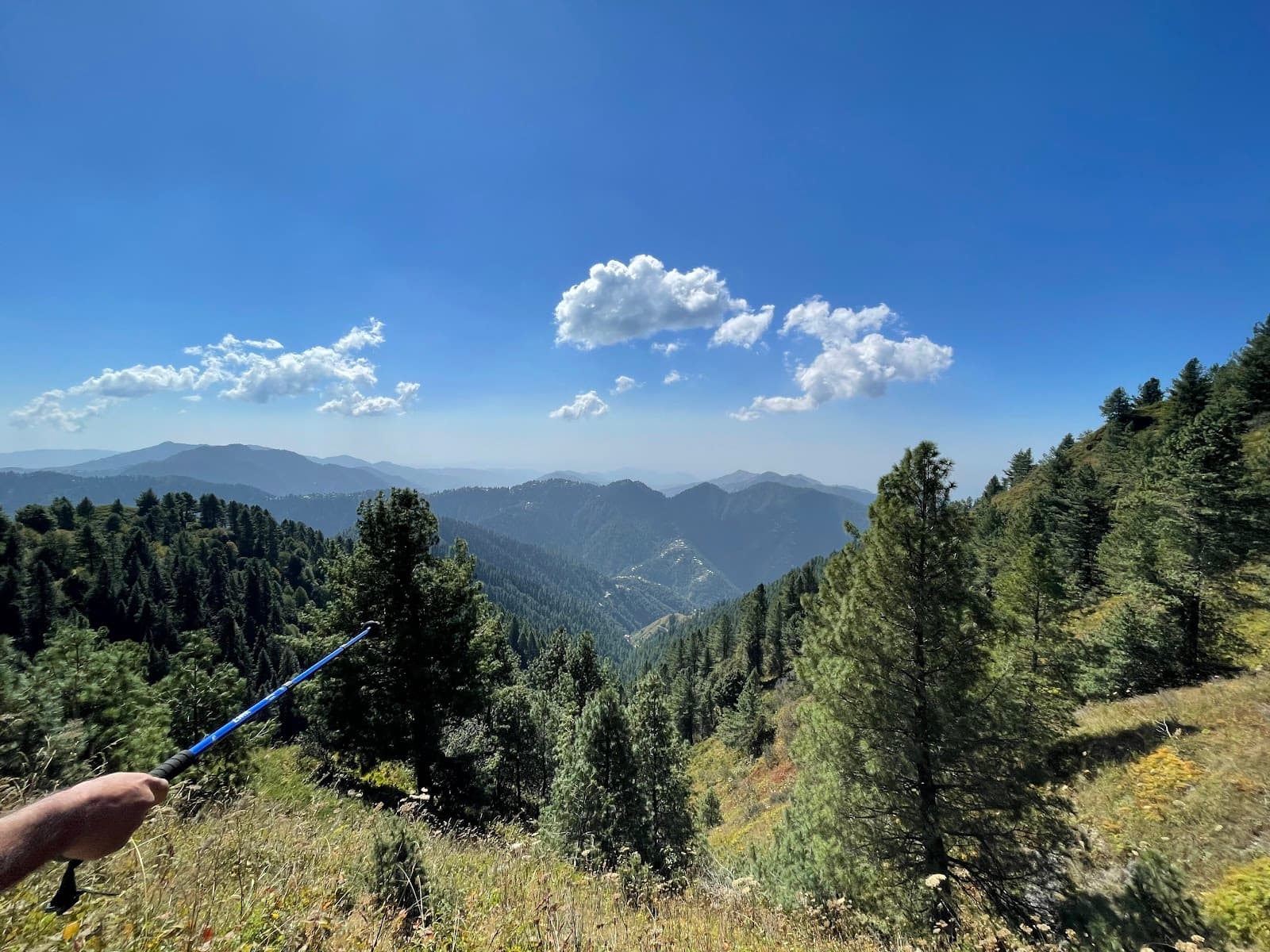
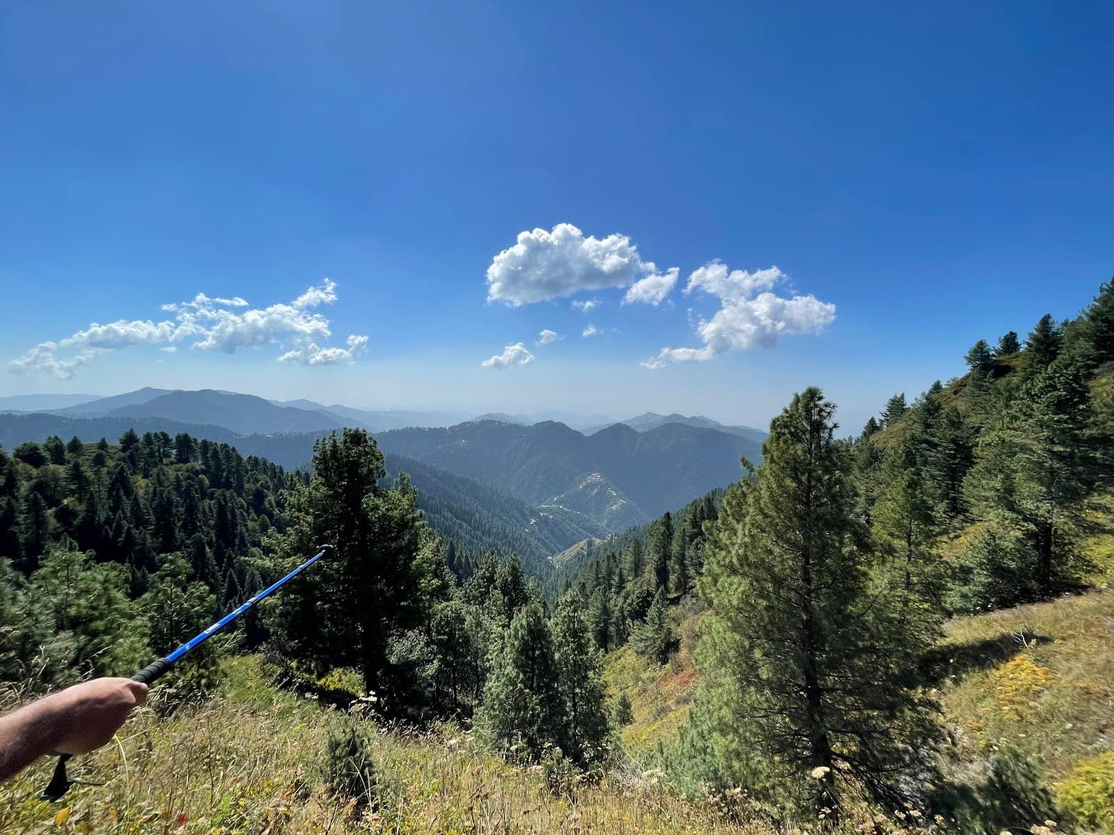
Miranjani Summit Views
Miranjani Top
Panoramic vistas of Nathiagali, Mushkpuri Peak, and potentially Nanga Parbat on clear days. A truly breathtaking reward.
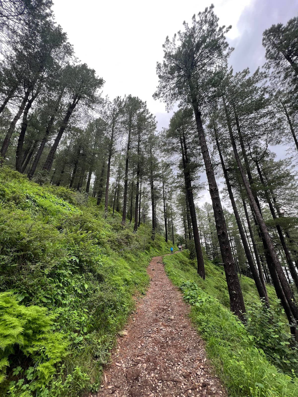
The Trekking Trail
Trail from Nathiagali
An intermediate 6 km trail through lush forests, offering a moderate challenge and immersive nature experience.
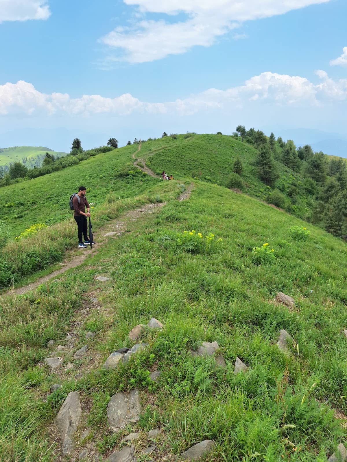
Dana Meadows
Near Miranjani
Picturesque meadows offering a serene escape with natural beauty and a peaceful ambiance.
Plans like a pro.
Thinks like you
Planning Your Visit
Best Time to Trek Miranjani
What to Pack for Miranjani
Best Times
Insider Tips
from TikTok, Instagram & Reddit
Carry Water & Snacks
Food on the peak is expensive. Bring your own water and snacks to stay energized. :water_wave:
Wear Comfortable Shoes
The trail is intermediate. Good hiking shoes are essential for grip and comfort. :athletic_shoe:
Check Weather Forecast
Mountain weather changes fast. Be prepared for rain or cooler temperatures. ☁️
Start Early
Beat the crowds and enjoy the serene morning views. Best light for photos too! 🌅
Tips
from all over the internet
Carry Water & Snacks
Food on the peak is expensive. Bring your own water and snacks to stay energized. :water_wave:
Wear Comfortable Shoes
The trail is intermediate. Good hiking shoes are essential for grip and comfort. :athletic_shoe:
Check Weather Forecast
Mountain weather changes fast. Be prepared for rain or cooler temperatures. ☁️
Start Early
Beat the crowds and enjoy the serene morning views. Best light for photos too! 🌅
Consider Dagri Bangla
For a longer trek, extend your hike to Dagri Bangla from the Miranjani endpoint. :hiking_boot:
What Travellers Say
Reviews Summary
Visitors rave about the Miranjani Trail's stunning natural beauty and rewarding summit views, calling it a must-visit for nature lovers. While the trek is considered intermediate and can be steep, the memorable experience and peaceful atmosphere are consistently praised. Some note that food options on the peak are expensive, and the trail can be challenging for beginners.
"Amazing experience
Track was steepy but it's memorable
I must reccomend to everyone to go there, explore nature, enjoy peace with amazing views and enjoy the height peak in galiyat"
Innam Ur Rehman
"Best place for hiking"
Baq - The Explorer
"Fell in love with this place can spend a whole day watching the beautiful scenery.
The track is a bit difficult for those who never go on trail or goes once or twice a year. Its an best place for nature lovers ."
Talha Ahmed
What People Like
What People Dislike
Frequently Asked Questions
🚇 🗺️ Getting There
From Islamabad, you can drive to Nathiagali, which is the starting point for the Miranjani Trail. The drive typically takes 2-3 hours. You can hire a taxi or use your own vehicle. Some travelers also mention reaching Nathiagali via public transport and then hiring a local jeep or taxi to the trailhead.
Parking can be limited, especially during peak season. It's advisable to arrive early or inquire locally about designated parking areas. Some visitors mention parking near hotels or designated spots in Nathiagali.
You can take a bus or van from Islamabad to Nathiagali. From Nathiagali, you might need to arrange local transport like a jeep or taxi to get closer to the actual trailhead, though many start the trek directly from Nathiagali town.
The Miranjani trek is approximately 6 kilometers (about 3.7 miles) one way from Nathiagali to the summit. The total round trip is about 12 km. +1
While camping is popular in the Galiyat region, specific restrictions for the Miranjani trail itself might exist. It's best to check with local authorities or guides. Some users mention camping around Dana Meadows, which is near the trail.
🎫 🎫 Tickets & Entry
There is generally no entry fee or ticket required for the Miranjani Trail itself. However, you might encounter small charges for parking or if you use local services.
The trail is open 24/7 as it's a natural hiking path. However, it's highly recommended to trek during daylight hours for safety and better visibility. Early mornings and late afternoons are popular.
Yes, you can hire local guides in Nathiagali. They can be very helpful, especially if you're unfamiliar with the trail or want to learn more about the area.
Typically, no special permits are required for hiking the Miranjani Trail. It's a popular public trekking route.
Yes, Miranjani can be visited year-round. Autumn offers beautiful foliage, spring has blooming flowers, and winter can be magical with snow, though more challenging.
🎫 🏞️ Onsite Experience
The Miranjani trek is considered intermediate. It's about 6 km long with an elevation gain of around 600 meters. It's manageable for most people with moderate fitness, but can be challenging for those new to hiking. +1
Expect lush green forests, diverse flora, and stunning mountain views. The trail winds through beautiful landscapes, offering a true immersion in nature.
Restrooms are generally not available on the trail itself. There might be some small stalls selling snacks and drinks at the summit, but they are often expensive. It's best to use facilities in Nathiagali before starting.
Starting early in the morning is highly recommended to avoid crowds and enjoy the cooler temperatures and beautiful sunrise views. Late afternoon also offers lovely light.
Yes, some trekkers extend their journey to Dagri Bangla, which is further along the trail. This offers a more challenging and rewarding experience for seasoned hikers.
🍽️ 🍽️ Food & Dining
Nathiagali town offers various restaurants and cafes serving local cuisine. At the Miranjani summit, there are a few stalls selling snacks and drinks, but they are significantly more expensive than in town.
Yes, there are usually a few vendors at the summit selling snacks, tea, and hot beverages. However, the selection is limited and prices are inflated.
In Nathiagali, you can find a range of Pakistani dishes, including local specialties, along with standard cafe fare. Many hotels also have their own restaurants.
Absolutely. Bringing your own water and snacks is highly recommended to save money and ensure you have what you need during the hike.
The trail itself offers many beautiful spots to stop and enjoy a packed lunch amidst nature. The meadows and clearings along the path are ideal for a picnic.
📸 📸 Photography
The summit offers breathtaking panoramic views, perfect for landscape photography. The forest trails themselves, with dappled sunlight and lush greenery, also make for stunning shots. Don't miss the meadows!
Early morning offers soft, golden light and fewer crowds, ideal for capturing the serene beauty. Late afternoon provides a warm glow. Midday sun can be harsh.
Drone usage regulations can vary. It's advisable to check with local authorities or park management before flying a drone to ensure compliance with any rules.
A wide-angle lens is great for landscapes. A telephoto lens can be useful for capturing distant peaks. A sturdy tripod can help with low-light conditions or long exposures.
Keep an eye out for unique flora, interesting rock formations, and the play of light and shadow in the forest. The views of the surrounding valleys and mountains are a must-capture.
Social
from TikTok, Instagram & Reddit