
Tjeldbergtinden
A steep, rewarding hike near Svolvær offering breathtaking 360° views of the Lofoten Islands, especially magical under the midnight sun.

Highlights
Must-see attractions
Social
From TikTok & Reddit
Best Time
Midnight sun magic!
Tjeldbergtinden
Best Time
Midnight sun magic!
Highlights
Must-see attractions
A steep, rewarding hike near Svolvær offering breathtaking 360° views of the Lofoten Islands, especially magical under the midnight sun.
"Wow - what a cool hike that was at 11pm! The views are stunning."
👟 Sturdy Hiking Boots Needed
Essential for steep, slippery, and muddy sections. Trekking poles are a lifesaver on descent .
🗺️ Download Offline Maps
Google Maps is not enough. Use Norgeskart Outdoors for reliable navigation .

Highlights
Discover the most iconic attractions and experiences
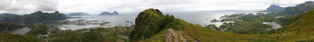
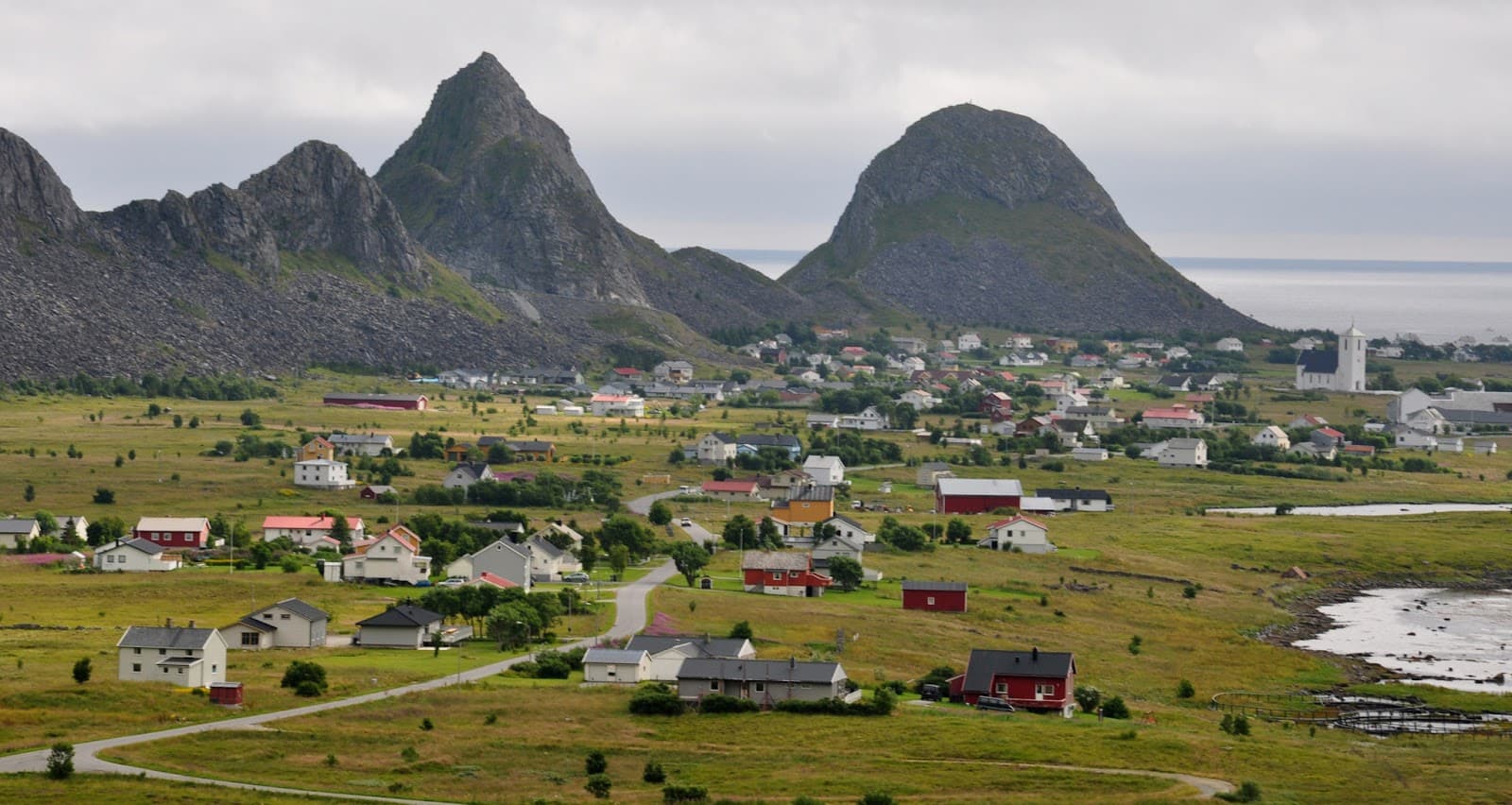
Panoramic Summit Views
Summit of Tjeldbergtinden
360-degree views of Svolvær and the surrounding Lofoten Islands. Absolutely worth the climb!

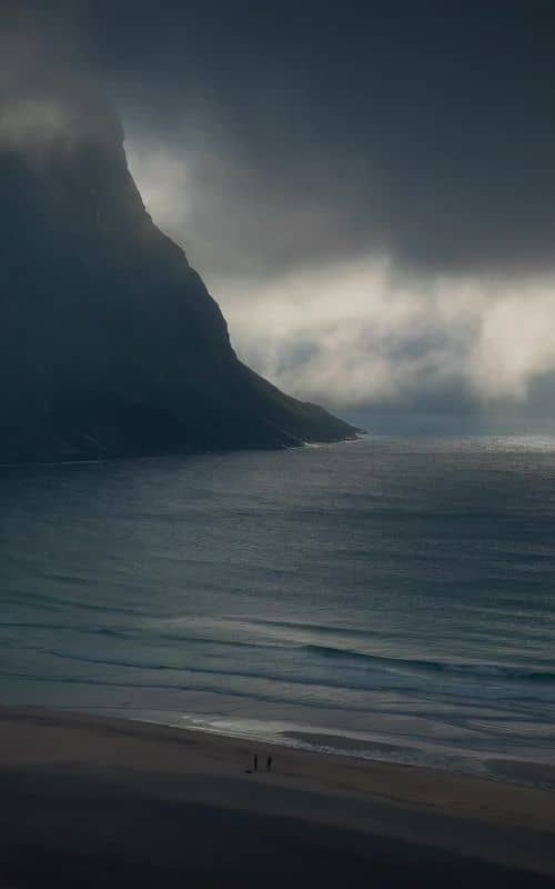
Midnight Sun Hike
Tjeldbergtinden trail
Experience an unforgettable hike under the midnight sun for surreal lighting and stunning vistas.

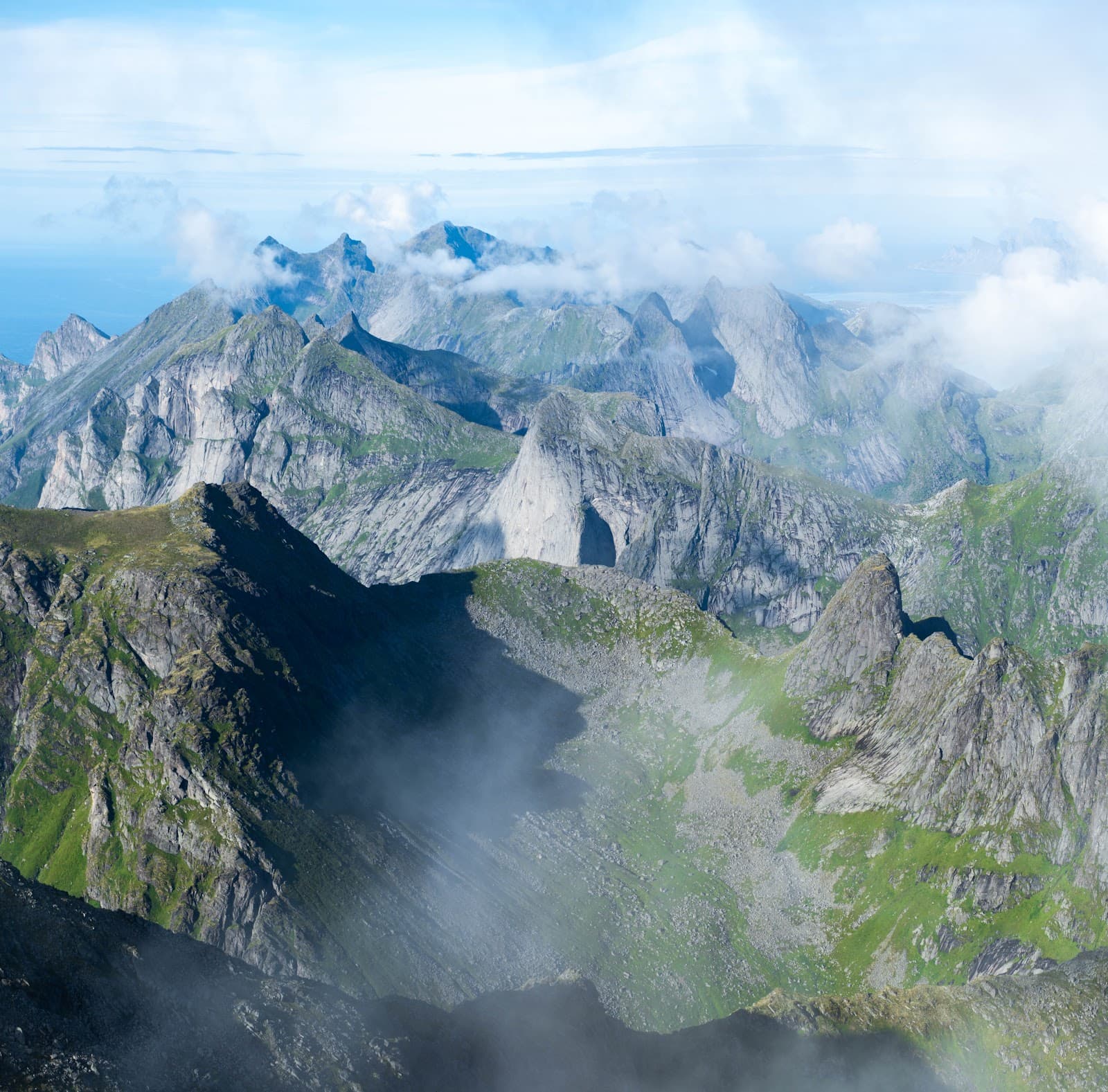
Challenging Peak Scramble
Western side of the saddle
A thrilling scramble to the highest point, with an optional chain for a safer descent.
Plans like a pro.
Thinks like you
Planning Your Visit
Weather Preparedness is Key
Trail Difficulty & Safety
Best Times
Insider Tips
from TikTok, Instagram & Reddit
👟 Sturdy Hiking Boots Needed
Essential for steep, slippery, and muddy sections. Trekking poles are a lifesaver on descent.
🗺️ Download Offline Maps
Google Maps is not enough. Use Norgeskart Outdoors for reliable navigation.
☀️ Be Ready for Weather Shifts
Rapid changes are common. Pack layers and waterproofs for sun, wind, and rain.
⏱️ Allow Ample Time
The hike can take 3-4 hours roundtrip, especially with photo stops.
Tips
from all over the internet
👟 Sturdy Hiking Boots Needed
Essential for steep, slippery, and muddy sections. Trekking poles are a lifesaver on descent.
🗺️ Download Offline Maps
Google Maps is not enough. Use Norgeskart Outdoors for reliable navigation.
☀️ Be Ready for Weather Shifts
Rapid changes are common. Pack layers and waterproofs for sun, wind, and rain.
⏱️ Allow Ample Time
The hike can take 3-4 hours roundtrip, especially with photo stops.
⬆️ Consider the Chain
Use the chain for a safer descent from the peak, especially in wet conditions.
What Travellers Say
Reviews Summary
Visitors rave about the spectacular 360-degree summit views of Svolvær and the Lofoten Islands, calling the hike incredibly rewarding. The unique experience of hiking under the midnight sun is a major highlight. However, many caution that the trail is steeper and more challenging than expected, requiring good physical condition and careful attention to safety, especially on the descent.
"We really enjoyed this trail. Mid September , drizzle , no wind lower part , strong winds at peak. Myself and two teenage boys , moderate to hard difficulty at the peak. Very quiet trail, started 11am , took around 3 hours and met a total of 4 people . I recommend to follow the route shown in 1st photo . Uphill first part was not too hard . Once towards the peak the wind kicks in harder and one needs to pay more attention . Once at the peak the down part can be a challenge . Thankfully there’s a chain to use to help come down. Slippery muddy parts on the downhill probably as it was raining by then . Views are fantastic and really rewarding !"
Rob
"The hike Tjeldbergtind near the town Svolvaer is pretty amazing. The 360 degree views at the top are stunning."
Marc Overeem
"Wow - what a cool hike that was at 11pm
Make sure you are prepared for rapid change in the weather
We were sitting in shorts and t-shirts at 1am but at 1.15am on the descent, the fog and wind came in at a frightening speed, it was so windy!"
Mark Reeves
What People Like
What People Dislike
Frequently Asked Questions
🚇 🗺️ Getting There
Tjeldbergtinden is located near Svolvær. You can typically drive to the trailhead, which is often marked. Some visitors mention it's a short walk from the signpost. Parking availability can vary, so arriving early is advisable.
While specific public transport routes directly to the trailhead might be limited, Svolvær is well-connected. You could potentially take a bus to Svolvær and then arrange local transport or a taxi to the trailhead. Check local bus schedules for the most up-to-date information.
The trailhead is generally well-marked and accessible from the vicinity of Svolvær. Look for signage indicating the start of the Tjeldbergtinden hike. It's often described as a short walk from a signpost.
Yes, cycling is a popular way to explore Lofoten, and you can cycle to the area around Tjeldbergtinden. However, the hike itself is best done on foot. Be prepared to secure your bike safely at the trailhead.
Parking is usually available near the trailhead, but it can fill up, especially during peak season. Arriving early in the morning or later in the evening can increase your chances of finding a spot.
🎫 🎫 Tickets & Entry
No, Tjeldbergtinden is a natural hiking trail and does not require an entrance fee or tickets. It's a free-to-access natural attraction.
Tjeldbergtinden is accessible year-round, 24 hours a day. However, hiking during daylight hours or the midnight sun season is recommended for safety and enjoyment.
The best time to hike Tjeldbergtinden is generally from May to September when the weather is more favorable and the midnight sun is visible. Winter hiking is possible but requires advanced skills and equipment due to snow and ice.
There are no booking requirements for Tjeldbergtinden. It's a public hiking trail that you can visit spontaneously.
There isn't a dedicated visitor center at Tjeldbergtinden. Information about the trail and surrounding area is best found online or at local tourist information points in Svolvær.
🎫 🧭 Onsite Experience
Tjeldbergtinden is considered moderately difficult due to its steepness and the scramble to the summit. While the distance is short (around 4.2km roundtrip), the elevation gain (367m) and challenging terrain require good physical condition.
The hike typically takes 2-3 hours roundtrip, but this can vary depending on your pace, fitness level, and how much time you spend enjoying the views at the summit.
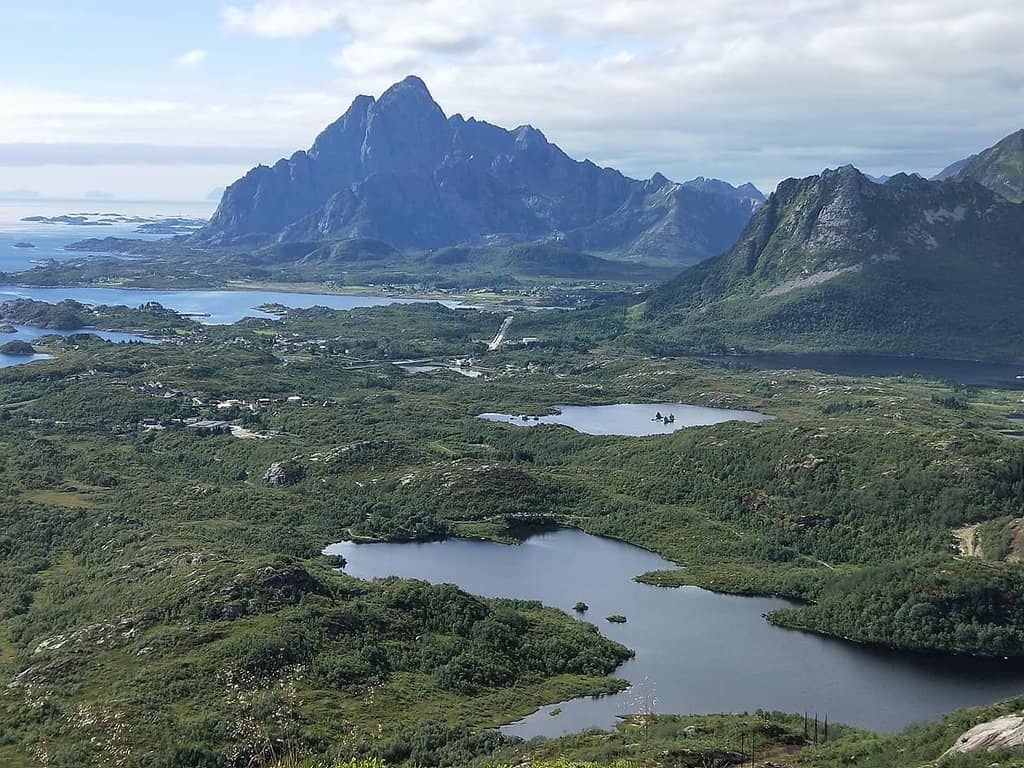
Expect stunning 360-degree panoramic views of Svolvær, the surrounding islands, fjords, and the Norwegian Sea. The vistas are particularly spectacular during the midnight sun.
There are no facilities at the summit. It's a natural peak, so be prepared to carry everything you need with you, including water and snacks.
While many enjoy solo hikes, it's crucial to be well-prepared. The trail can be challenging and weather can change rapidly. Inform someone of your plans, carry a fully charged phone, and consider the safety advice provided in reviews.
📸 📸 Photography
The golden hours around sunrise and sunset offer beautiful light, but the midnight sun provides a unique, ethereal glow for photography. The 360-degree views are stunning at any time of day.
A wide-angle lens is great for capturing the expansive landscapes. Consider a polarizing filter to enhance the blues of the sky and sea. A sturdy tripod can be useful for low-light conditions or long exposures, especially during the midnight sun.
The summit offers the most iconic panoramic shots. However, keep an eye out for interesting rock formations and viewpoints along the trail that offer unique perspectives of Svolvær and the coastline.
Drone regulations can vary. Always check the latest local rules and regulations regarding drone usage in Norway and the Lofoten Islands before flying. Respect wildlife and other hikers.
Expect breathtaking landscape photos featuring dramatic cliffs, the charming town of Svolvær, the vast Norwegian Sea, and potentially the Northern Lights in winter or the midnight sun in summer.
For Different Travelers
Tailored advice for your travel style
👨👩👧 Families with Kids
Consider the weather conditions carefully; a sudden change can make the hike more difficult for younger hikers. Bringing plenty of snacks and water is essential. While the views are a huge draw, the challenging nature of the trail might be better suited for families with teenagers or children who have prior hiking experience on similar terrain.
🚶♀️ Solo Adventurers
Be prepared for all weather conditions, as Lofoten weather can change rapidly. The trail's challenging sections, including the scramble to the summit and the potential for slippery surfaces, mean that extra caution is needed. Trekking poles can provide added stability. Downloading offline maps is a must, as mobile service can be spotty.
📸 Photography Enthusiasts
Bring a wide-angle lens to encompass the vast landscapes and consider a polarizing filter to enhance the colors of the sky and water. A sturdy tripod can be beneficial for capturing the best light, especially during the extended daylight hours of summer. Be prepared for dynamic weather, which can add dramatic clouds and light to your shots. Remember to also capture the details of the trail itself, the rugged terrain, and the sense of adventure.
Deep Dives
In-depth insights and expert knowledge
Navigating the Tjeldbergtinden Trail
There are a couple of approaches to the summit. The main Dalen route is described as a more consistent climb, while another trail branches off the Linken trail. Some reviews suggest the Linken trail can be deceptively steep after a certain point, feeling treacherous even in good conditions.
Safety is a significant consideration. Unlike North American trails, Tjeldbergtinden may lack extensive railings or supports. Trekking poles are highly advised for stability, particularly on the descent.
The Magic of Midnight Sun Hiking
Imagine standing at the summit, the sun still high in the sky at 11 PM or even 1 AM, with unparalleled views stretching out before you. The light can create dramatic shadows and highlight the rugged beauty of the mountains and the sea. It's a photographer's dream, offering a unique opportunity to capture the Lofoten Islands in a way that's impossible at other times of the year.
However, it's crucial to be prepared for rapid weather changes, even under the midnight sun. As one reviewer noted, they were in shorts and t-shirts at 1 AM, but by 1:15 AM on the descent, fog and strong winds had rolled in with frightening speed.
Understanding Tjeldbergtinden's Terrain and Safety
The path can be muddy and slippery, especially after rain, and the ascent to the peak involves a scramble. For the final push to the summit, there's a notable chain to aid climbers, which is highly recommended for descent, particularly in adverse conditions.
Given these factors, proper footwear is non-negotiable. Sturdy hiking boots with good grip are essential. Many hikers also found trekking poles to be invaluable for maintaining balance and reducing strain, especially on the steep downhill sections.


Social
from TikTok, Instagram & Reddit