
Struve Geodetic Arc Lille Raipas
Hike to a UNESCO World Heritage site for breathtaking panoramic views of Alta and the Altafjord.
Highlights
Must-see attractions

Social
From TikTok & Reddit
Best Time
Spectacular views
Struve Geodetic Arc Lille Raipas
Best Time
Spectacular views
Highlights
Must-see attractions
Hike to a UNESCO World Heritage site for breathtaking panoramic views of Alta and the Altafjord.
"The view makes up for a lot, especially after sunset. "
🎯 Use Coordinates for GPS
Google Maps can be tricky; use coordinates 69.93026956749787, 23.32757137964319.
🥾 Waterproof Footwear Recommended
Trails can be very wet and muddy, especially after rain.

Highlights
Discover the most iconic attractions and experiences
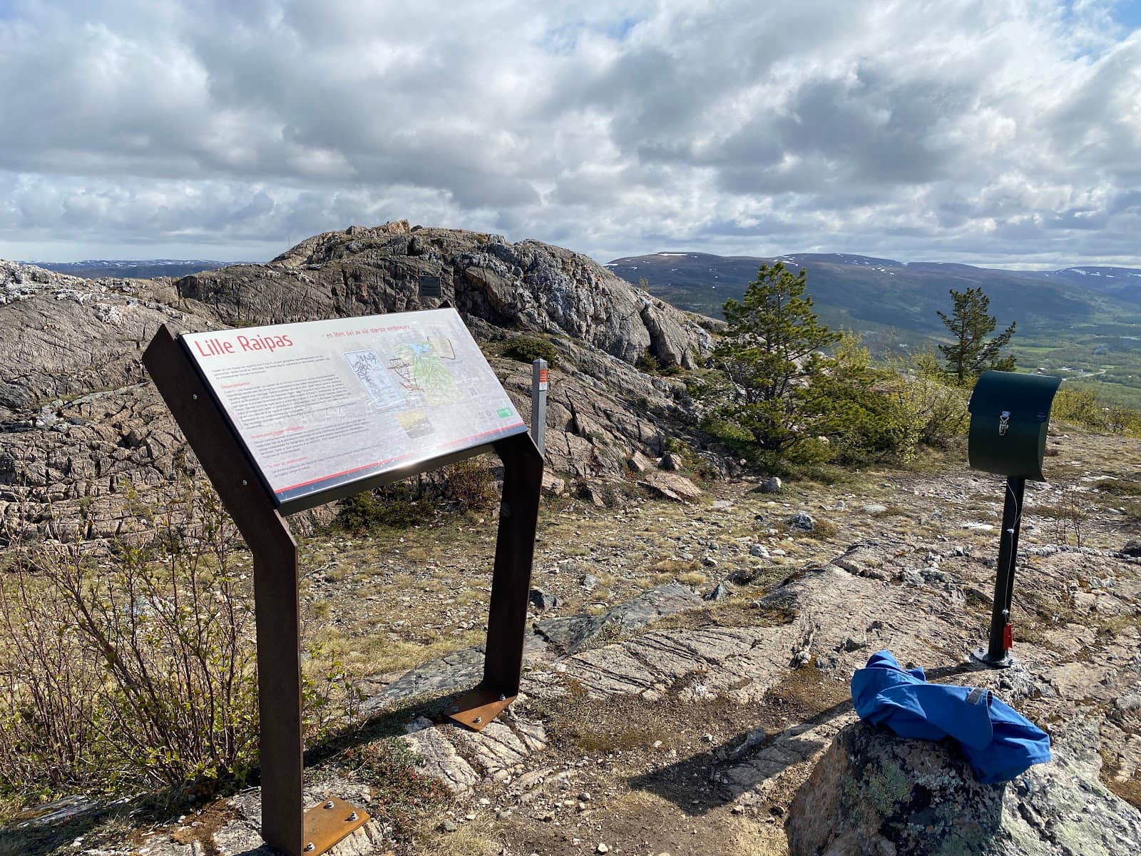
Struve Geodetic Arc Monument
Summit
The historic point itself, a UNESCO World Heritage site, marking a significant scientific achievement.
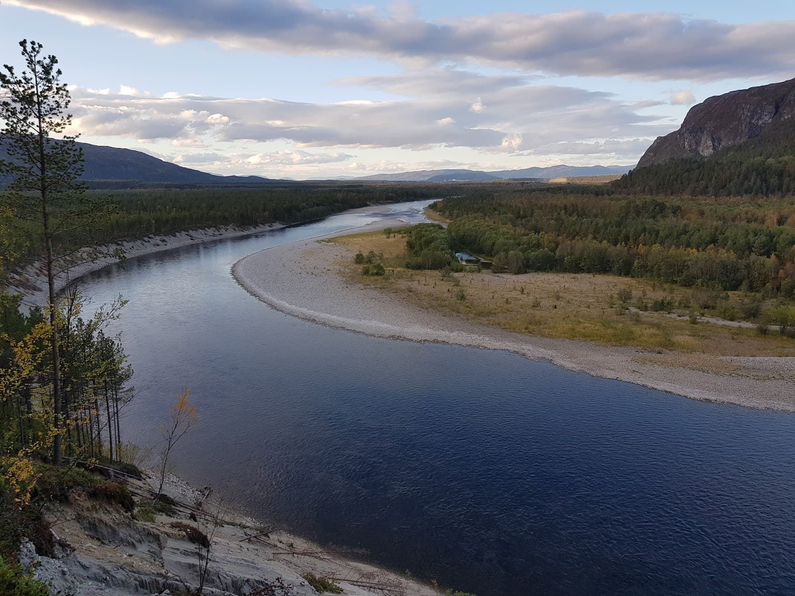
Panoramic Alta Views
Summit
Breathtaking vistas of Alta and the Altafjord, especially stunning after sunset.

Varied Nature Trail
Trail to summit
An enjoyable hike through beautiful, diverse natural landscapes.
Plans like a pro.
Thinks like you
Planning Your Visit
Trail Conditions & Timing
Navigation & Access
Best Times
Insider Tips
from TikTok, Instagram & Reddit
🎯 Use Coordinates for GPS
Google Maps can be tricky; use coordinates 69.93026956749787, 23.32757137964319.
🥾 Waterproof Footwear Recommended
Trails can be very wet and muddy, especially after rain.
⏱️ Allow 1.5-2 Hours
Hike takes about 45 mins to 2 hours depending on fitness and breaks.
📸 Capture the Sunset
The view after sunset is highly recommended and worth the visit.
Tips
from all over the internet
🎯 Use Coordinates for GPS
Google Maps can be tricky; use coordinates 69.93026956749787, 23.32757137964319.
🥾 Waterproof Footwear Recommended
Trails can be very wet and muddy, especially after rain.
⏱️ Allow 1.5-2 Hours
Hike takes about 45 mins to 2 hours depending on fitness and breaks.
📸 Capture the Sunset
The view after sunset is highly recommended and worth the visit.
What Travellers Say
Reviews Summary
Visitors praise the Struve Geodetic Arc Lille Raipas for its stunning panoramic views of Alta and the Altafjord, especially after sunset, and the historical significance of the monument. The hike itself is considered enjoyable and a good short activity, though some note the trail can be very wet and muddy, and navigation can be tricky if relying solely on standard GPS.
"The parking is easy to find and get to. The hike takes about 90 minutes and is easy to do, however depending on the recent weather the trail might be very wet. I wish the trail was better prepared but the view makes up for a lot, especially after sunset."
Erik N
"Good short hike. Doable in about 45 min. Great view (Alta and Altafjord)"
Leo De Jong
"Great hiking opportunity.
Relatively steep, so set aside time for your fitness level."
Olav Olsen
What People Like
What People Dislike
Frequently Asked Questions
🚇 🗺️ Getting There
Google Maps can be unreliable. It's best to search for 'Trailhead For Lille Raipas' or use the coordinates 69.93026956749787, 23.32757137964319 to navigate accurately.
Yes, parking is generally easy to find and access at the trailhead.
Information on public transport is limited, but driving or using a taxi to the trailhead is the most common method.
While the trail is generally clear, having GPS or a map is advisable, especially if conditions are poor.
The trail is generally discernible, but can become overgrown or muddy, making clear markings less apparent at times.
🎫 🎫 Tickets & Entry
No, visiting the Struve Geodetic Arc Lille Raipas is free of charge. It's an outdoor natural site.
As an outdoor natural monument and hiking area, there are no set opening or closing hours. You can visit anytime.
There is no entrance fee to hike to the Struve Geodetic Arc Lille Raipas.
While possible, winter visits may be challenging due to snow and ice. Check local conditions before planning a winter trip.
No booking or reservation is necessary for visiting the Struve Geodetic Arc Lille Raipas.
🎫 🏞️ Onsite Experience
The hike typically takes between 45 minutes to 2 hours, depending on your pace and how long you spend at the summit.
It's considered a good short hike, with some uphill sections. It's not overly steep but requires a moderate level of fitness.
You'll get great panoramic views of Alta and the Altafjord, which are particularly beautiful after sunset.
There are no specific facilities like restrooms or benches directly at the summit or along the trail.
The trail is generally doable for children, but the terrain can be wet and muddy, so supervision is advised.
📸 📸 Photography
The views are stunning throughout the day, but many visitors recommend visiting after sunset for dramatic lighting.
A wide-angle lens is great for capturing the panoramic views. A tripod can be useful for low-light photography after sunset.
The summit offers the best vantage points for the Altafjord and surrounding landscape. The monument itself is also a key subject.
Experiment with different angles to include the monument with the expansive landscape in the background.
The main challenges can be changing weather conditions, potential mud on the trail, and low light after sunset.
For Different Travelers
Tailored advice for your travel style
👨👩👧 Families with Kids
🚶♀️ Hikers & Nature Enthusiasts
📸 Photographers
Deep Dives
In-depth insights and expert knowledge


Social
from TikTok, Instagram & Reddit