Vidden Trail Fløyen Ulriken
Hike between Bergen's iconic peaks, Fløyen and Ulriken, across the scenic Vidden plateau. Expect stunning fjord views and a challenging but rewarding ...
Highlights
Must-see attractions

Social
From TikTok & Reddit
Best Time
Best chance for clear skies
Vidden Trail Fløyen Ulriken
Best Time
Best chance for clear skies
Highlights
Must-see attractions
Hike between Bergen's iconic peaks, Fløyen and Ulriken, across the scenic Vidden plateau. Expect stunning fjord views and a challenging but rewarding adventure.
"The views are gorgeous indeed, but don't underestimate the climb and the unpredictable weather!"
🥾 Sturdy Boots Essential
Don't hike in sneakers! Rocky, wet terrain requires good grip and support. Your feet will thank you .
📱 Download Offline Maps
Trail signage is poor. Use a navigation app; cell service can be spotty .
Highlights
Discover the most iconic attractions and experiences

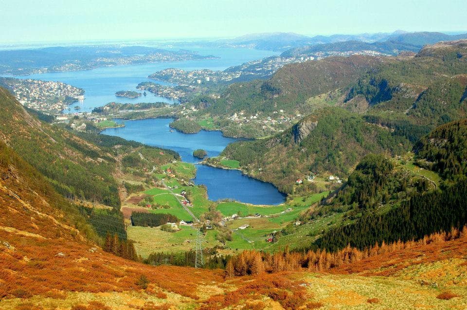
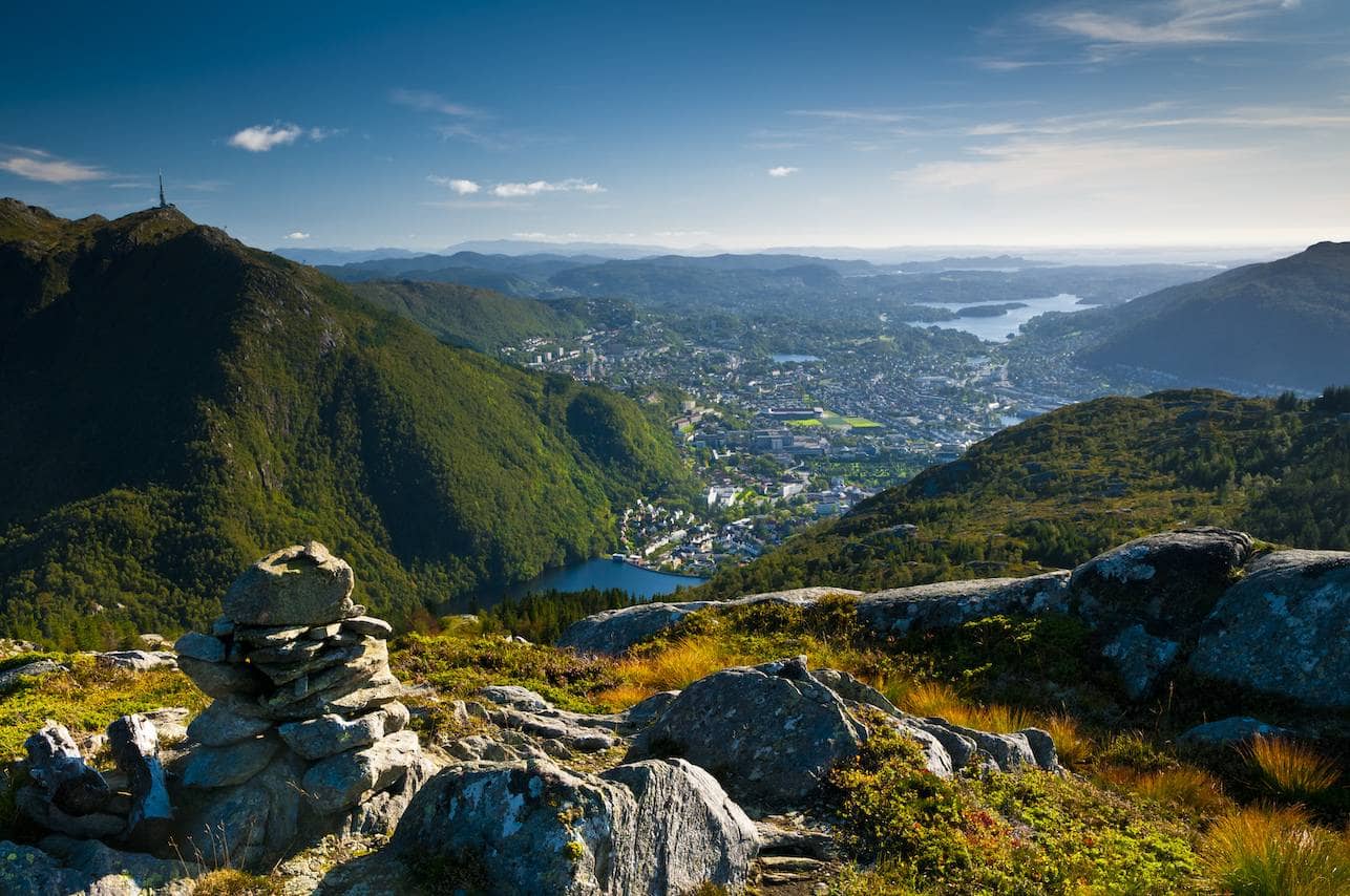
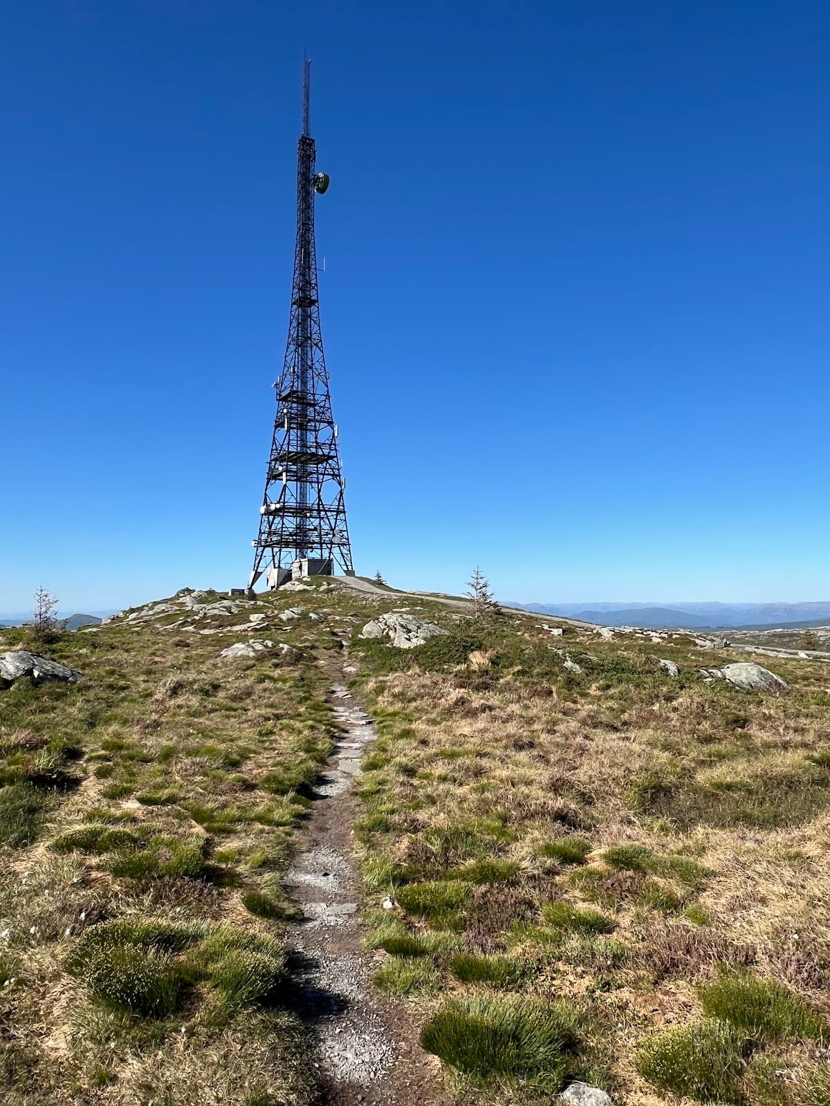
Panoramic Vistas
Along the Vidden Trail
Breathtaking views of Bergen, fjords, and surrounding islands. On clear days, you can see as far as Folgefonna glacier.

Mountain Summit Experience
Mount Ulriken
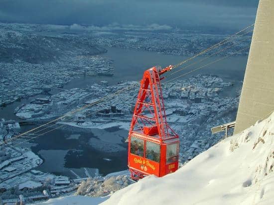
Reach the highest of Bergen's seven mountains via cable car or a challenging hike, offering a dramatic starting point for your trek.
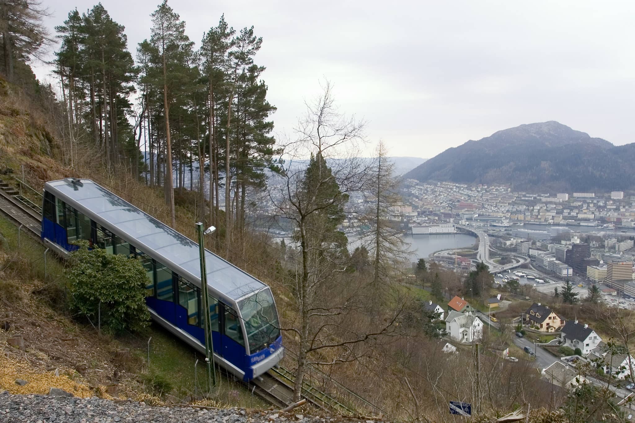
Funicular Fun
Mount Fløyen
Ride the iconic Fløibanen funicular up to Mount Fløyen for stunning city views and a gentler introduction to Bergen's mountains.
Plans like a pro.
Thinks like you
Planning Your Visit
Footwear is Key
Navigation & Weather
Best Times
Insider Tips
from TikTok, Instagram & Reddit
🥾 Sturdy Boots Essential
Don't hike in sneakers! Rocky, wet terrain requires good grip and support. Your feet will thank you.
📱 Download Offline Maps
Trail signage is poor. Use a navigation app; cell service can be spotty.
💧 Pack Plenty of Water
No facilities on the trail. Stay hydrated for this 5+ hour trek.
🧥 Waterproofs are a Must
Bergen weather changes fast. Be ready for rain and wind, even on a sunny day.
Tips
from all over the internet
🥾 Sturdy Boots Essential
Don't hike in sneakers! Rocky, wet terrain requires good grip and support. Your feet will thank you.
📱 Download Offline Maps
Trail signage is poor. Use a navigation app; cell service can be spotty.
💧 Pack Plenty of Water
No facilities on the trail. Stay hydrated for this 5+ hour trek.
🧥 Waterproofs are a Must
Bergen weather changes fast. Be ready for rain and wind, even on a sunny day.
⏱️ Allow Ample Time
5 hours is average, but factor in stops and photos. It can take longer!
What Travellers Say
Reviews Summary
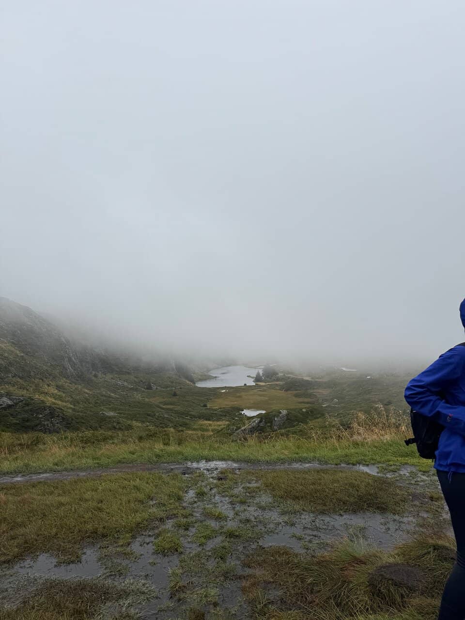
The Vidden Trail offers breathtaking panoramic views of Bergen and its surroundings, a major draw for visitors. Hikers appreciate the challenging yet rewarding nature of the trek, connecting two of Bergen's iconic mountains. However, many note that the trail is not 'easy' as sometimes described, citing difficult terrain, poor signage, and unpredictable weather as significant challenges.
"I don’t understand how you can call a hike « easy » if it includes climbing at some parts of the way. But the views are gorgeous indeed. It took us 8 hours with stops to take pictures + 2 hours walking in heavy rain"
Daria Iliukhina
"From Ulriken via Vidden to Fløyibanen.
With 230+ days of rain per year you are likely to experience this hike under moderately difficult conditions - inside clouds, difficult to see path. Rocky/uneven surface in the first half of the hike. Rain can be strong when winds are pushing clouds up the mountain passes. Bring good rain jacket and pants and warm clothes. In some passages the hiking path is a water way. If it has rained a lot, then expect soaked shoes even if you try to avoid it. A bit of easy climbing in some places, albeit slightly risky if water is flowing down the rocks. Signage is mostly poor. Altitude meters are not that challenging.
From Ulriken the first sign shows the direction for Ulriken with a red background, while other destinations have other colors, leading you believe this is the colorcode for the route. Its not. It's probably some difficulty rating or just random. Instead you are looking for rusty iron pipes about 2.5m high with an arrow on top. Towards the middle section this is replaced with stone nozzles with a blue sign on top pointing to Fløyen and back to Ulriken. They are mostly spaced close enough that you wont get lost when inside clouds, but in a few places it can be a guessing game. In the last section the signs are too far apart for navigation, and the distance to fløyen actually increases according to the signs. Highly recommend using an app or website for navigation. I suspect the total distance of 13 km is in birds perspective too. 5h at moderate pace."
Søren Poulsen
"Vidden between Ulriken and Fløyen is one of the most popular tours in Bergen. Beautiful view over Bergen and the region.
You can start and end the tour by taking the Ulrikensbanen (walking up popular trail "Oppstemten" which consists of 750 of Sherpa stairs straight up) or the Fløibanen (can walk from city center up the mountain) or you can walk down to the centre. Between these two beautiful city mountains lies "Vidden" and from here you can see the fjords around Bergen and the archipelago beyond.
From the top of Ulriken and over Vidden towards Fløyen, it is well signposted and there are many cairns to follow. On a fine day, you can enjoy the beautiful view all the way to Folgefonna.
Estimated time: 5 hours (without stops and making 📸 for me takes 3 h)
Length: 15 km
Must have good 👞 and alot of water !!!"
Guide travels 2
What People Like
What People Dislike
Frequently Asked Questions
🚇 🗺️ Getting There
You can start the Vidden Trail from either Mount Fløyen or Mount Ulriken. To reach Fløyen, take the Fløibanen funicular from the city center. For Ulriken, take the Ulriksbanen cable car. Both offer stunning views as you ascend.
Yes, the Vidden Trail connects Mount Fløyen and Mount Ulriken. You can hike in either direction. Many choose to start at Ulriken and finish at Fløyen, taking the funicular down to the city.
The Fløibanen funicular and Ulriksbanen cable car are the primary ways to access the trailheads from Bergen city center. Both are easily accessible via walking or local buses.
If you end at Fløyen, the Fløibanen funicular offers a direct and scenic descent. If you end at Ulriken, you can take the Ulriksbanen cable car back down or hike down the 'Oppstemten' trail, which is very steep.
Limited parking is available near the base stations of the Fløibanen and Ulriksbanen. It's generally recommended to use public transport or walk from the city center.
🎫 🎫 Tickets & Entry
The Vidden Trail itself is free to access. However, you will need to purchase tickets for the Fløibanen funicular or Ulriksbanen cable car to reach the starting points on the mountains.
Operating hours vary seasonally. It's best to check the official websites for the Fløibanen and Ulriksbanen for the most up-to-date schedules before your visit.
Ticket prices vary depending on whether you purchase a one-way or round-trip ticket. Check the respective websites for current pricing information.
Yes, it's often possible to purchase tickets for the Fløibanen and Ulriksbanen online in advance, which can save you time, especially during peak season.
Discounts may be available for children, seniors, or families. Check the official websites for details on any available offers.
🎫 🧭 Onsite Experience
The Vidden Trail is approximately 13-15 km long. Most people take around 5 hours to complete it, but this can vary significantly based on your pace, fitness level, and how often you stop for photos.
Signage can be poor, especially in foggy conditions. While there are cairns and some signs, it's highly recommended to use a navigation app or GPS device.
The trail is rocky, uneven, and can be wet. There are some sections with minor climbing. It's not a paved path and requires sturdy footwear.
Wear sturdy hiking boots, waterproof clothing (jacket and pants), and layers. The weather can change rapidly, and you should be prepared for rain and wind.
No, there are no restrooms or facilities along the Vidden Trail. You'll need to use facilities at the top of Fløyen or Ulriken before you start, or wait until you reach the city center.
🍽️ 🍎 Food & Dining
No, there are no food or drink facilities along the Vidden Trail. You must carry all your own food and water for the duration of the hike.
Pack high-energy snacks like trail mix, energy bars, sandwiches, and plenty of water. Consider bringing a warm drink in a thermos if hiking in cooler weather.
Both Mount Fløyen and Mount Ulriken have cafes or restaurants at their respective summit stations. Bergen city center also offers a wide variety of dining options.
While there are no designated picnic areas, you can stop at various points along the trail to enjoy your packed lunch with a view. Be sure to pack out all your trash.
Yes, both the Fløibanen and Ulriksbanen stations typically have cafes or kiosks where you can purchase snacks, drinks, and light meals before or after your hike.
📸 📸 Photography
The entire trail offers stunning photo opportunities, from panoramic views of Bergen and the fjords to unique rock formations and the changing mountain landscape. The summits of Fløyen and Ulriken are prime spots.
Early morning or late afternoon often provide the best light for photography, with softer shadows and warmer tones. However, even on a cloudy day, the dramatic atmosphere can make for compelling shots.
A smartphone camera is perfectly adequate for capturing the beauty of the Vidden Trail. If you're serious about photography, a DSLR or mirrorless camera with a wide-angle lens would be ideal for landscapes.
Always use a waterproof camera bag or a rain cover, especially if there's a chance of rain. Bergen is known for its unpredictable weather, so preparedness is key.
Keep an eye out for cairns and slightly elevated spots. The sections between Ulriken and Rundemanen, and as you approach Fløyen, offer particularly expansive vistas.
For Different Travelers
Tailored advice for your travel style
👨👩👧 Families with Kids
If you do attempt the Vidden Trail with older kids, ensure they have appropriate footwear and are prepared for the duration and terrain. The sense of accomplishment after completing such a hike can be immense. Alternatively, consider hiking only a portion of the trail or focusing on the more manageable routes around Fløyen or Ulriken. Always prioritize safety and be aware of your children's energy levels and the changing weather conditions.
🚶 Budget Travelers
Deep Dives
In-depth insights and expert knowledge
Navigating the Vidden Trail: Tips from the Community
The trail itself is a mix of rocky paths, uneven ground, and potential stream crossings. While some locals might consider it an 'easy' hike, for many international visitors, it's a moderate to challenging trek. The length is typically cited as 13-15 km, and it can take anywhere from 3 to 8 hours depending on your pace and how much time you spend enjoying the views or taking photos.
Key takeaway: Be prepared for a proper hike. Sturdy hiking boots are a must, and packing waterproofs, layers, ample water, and snacks is non-negotiable. The reward for this preparation is truly spectacular scenery, making the Vidden Trail a memorable Bergen experience.
What to Pack for the Vidden Trail
Beyond footwear, waterproof clothing is essential. This includes a good quality waterproof jacket and pants, as rain can be heavy and winds can drive it sideways. Layering is also key; bring moisture-wicking base layers and insulating mid-layers that you can add or remove as needed. Even on a seemingly clear day, conditions can change rapidly as you gain altitude.
Don't forget sufficient food and water. The hike can take several hours, and there are no shops or cafes along the way. Pack high-energy snacks, a packed lunch, and at least 1-2 liters of water per person. A thermos with a hot drink can be a welcome comfort on a chilly or wet day. Finally, consider bringing a small backpack to comfortably carry these essentials, along with a basic first-aid kit and your phone for navigation and photos.


Social
from TikTok, Instagram & Reddit