Eboshi-dake Japan
Hike Eboshi-dake for breathtaking panoramic views of Mount Aso's active crater and vast caldera.
Highlights
Must-see attractions

Social
From TikTok & Reddit
Best Time
Best visibility for views
Eboshi-dake Japan
Best Time
Best visibility for views
Highlights
Must-see attractions
Hike Eboshi-dake for breathtaking panoramic views of Mount Aso's active crater and vast caldera.
"Magnificent views of the crater and surrounding landscapes make this a must-do short hike."

🚶♀️ Hike Counter-Clockwise
Descend the less steep side for an easier experience. Trails can be muddy, so wear appropriate footwear.
👟 Wear Sturdy Shoes
The path involves mud, logs, and rocks. Good grip is essential, especially after rain.
Highlights
Discover the most iconic attractions and experiences
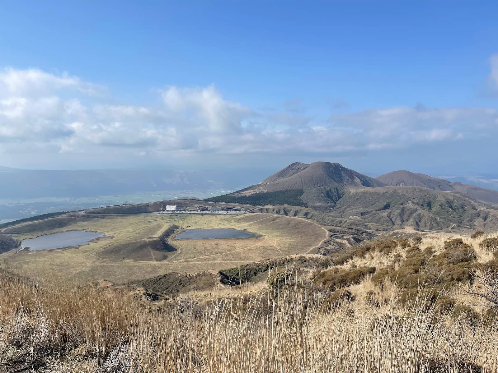
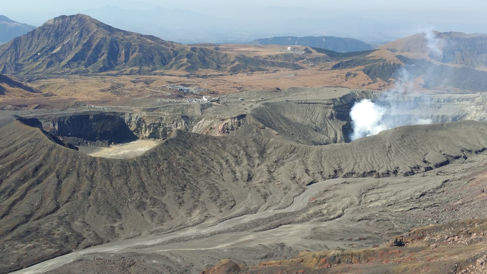
Nakadake Crater Views
Ridge overlooking Nakadake crater
Witness breathtaking views of the active Nakadake crater and the surrounding volcanic landscape.
Panoramic Aso Caldera
Summit of Eboshi-dake
From the top, enjoy sweeping vistas of the vast Aso caldera and, on clear days, distant Mount Unzen.

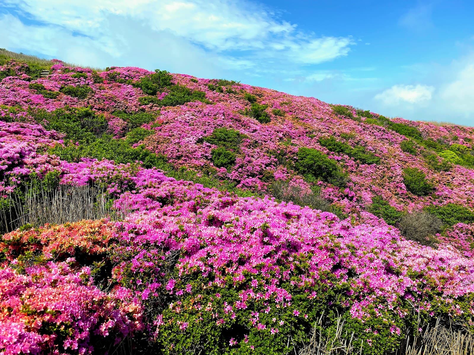
Kusasenri Grasslands
Base of the hike
Start your hike through serene green pastures, offering a peaceful prelude to the volcanic ascent.
Plans like a pro.
Thinks like you
Planning Your Visit
Timing is Everything
Trailhead Navigation
Best Times
Insider Tips
from TikTok, Instagram & Reddit
🚶♀️ Hike Counter-Clockwise
Descend the less steep side for an easier experience. Trails can be muddy, so wear appropriate footwear.
👟 Wear Sturdy Shoes
The path involves mud, logs, and rocks. Good grip is essential, especially after rain.
⏰ Allow 2 Hours
Factor in time for breaks and photos. The hike itself is about 1-1.5 hours round trip.
☁️ Check the Weather
Avoid hiking in rain; trails become slippery and views are obscured.
Tips
from all over the internet
🚶♀️ Hike Counter-Clockwise
Descend the less steep side for an easier experience. Trails can be muddy, so wear appropriate footwear.
👟 Wear Sturdy Shoes
The path involves mud, logs, and rocks. Good grip is essential, especially after rain.
⏰ Allow 2 Hours
Factor in time for breaks and photos. The hike itself is about 1-1.5 hours round trip.
☁️ Check the Weather
Avoid hiking in rain; trails become slippery and views are obscured.
📍 Find the Trailhead
It can be hidden near the volcano museum or heliport bus stop. Look for signs!
What Travellers Say
Reviews Summary
Visitors consistently praise Eboshi-dake for its magnificent panoramic views of the Aso caldera and Nakadake crater, making it a highly recommended short hike. The accessible loop trail and the scenic beauty of Kusasenri are frequently highlighted as major positives. However, some find the trailhead slightly difficult to locate, and the trail can become slippery and less enjoyable in wet conditions.
"Because we had limited time to spend on Mount Aso in March 2025, we decided to climb Eboshidake. Starting at the volcano museum, we climbed up the small hill-mountain Komatate, then counter-clockwise up Eboshidake, down, Eboshidake, and then rather than returning to the museum we exited closer to the heliport bus stop to go up to the Mountain Terminal. In total it took 2 hours with 30 minutes of break and a somewhat fast pace. I would recommend doing it counter-clockwise so the descent is less steep, and avoiding it if it is raining. There are beautiful views of the crater and surrounding landscapes."
Sarah Hasselman
"While it’s not a difficult hike up this peak from the Kusasenri carpark, the entrance to the trail can be a little hard to find. The view on top is simply magnificent (see the pics below).
If you have 2 hours to spare, I would recommend going on the trail starting from the carpark. With all our photo taking, it only took 1.5 hours to go up and down. At the top, if the sky is clear enough, you could see as far as Mount Unzen!"
Daniel Bok
"A 1.5h (1h if you move non stop) round trip hike up to the peak. Once you make it past the green pastures, it gets quiet and peaceful. Hike up mud paths, log steps and rocks to the top. I went clockwise, starting with the left side of the trail which brought me on the ridge overlooking Nakadake crater, then to the top overlooking the valley, and down the right with views of the green pastures beneath"
Rimmel Choong
What People Like
What People Dislike
Frequently Asked Questions
🚇 🗺️ Getting There
Eboshi-dake is accessible from the Kusasenri carpark area on Mount Aso. You can drive to the Kusasenri car park or take a bus to the Kusasenri-ga-hama bus stop. From there, the trailhead is a short walk away.
Yes, there is a large carpark at Kusasenri, which is the primary starting point for the Eboshi-dake hike.
Yes, buses operate to the Kusasenri-ga-hama bus stop, making it accessible via public transport from other parts of Mount Aso.
Most hikers start from the volcano museum carpark at Kusasenri. The trail is a loop, and you can choose to go clockwise or counter-clockwise.
The hike itself takes about 1 to 1.5 hours round trip, but allow 2 hours with breaks and photo stops.
🎫 🎫 Tickets & Entry
No, there are no entrance fees or tickets required to hike Eboshi-dake. It is a natural trail accessible to the public.
Eboshi-dake is an outdoor natural trail and is generally accessible at all times. However, hiking during daylight hours is recommended for safety and visibility.
While there isn't a dedicated visitor center at the summit, there is a volcano museum near the trailhead at Kusasenri which provides information about the area.
Guided tours may be available through local tour operators in the Mount Aso region, but they are not mandatory for accessing the trail.
Ensure you have comfortable hiking shoes, water, and check the weather forecast before heading out.
🎫 🥾 Onsite Experience
The hike is generally considered moderate. It involves some steep sections with mud paths, log steps, and rocks, but it's manageable for most fit individuals.
The summit offers stunning panoramic views of the Nakadake crater, the Aso caldera, and on clear days, Mount Unzen. The ridge overlooking Nakadake is particularly impressive.
Yes, Eboshi-dake is typically hiked as a loop trail starting from the Kusasenri carpark. You can choose to go clockwise or counter-clockwise.
Wear sturdy hiking shoes with good grip, comfortable clothing suitable for the weather, and consider bringing a light jacket.
Restrooms are available at the Kusasenri carpark area near the trailhead. There are no facilities on the trail itself.
📸 📸 Photography
The summit provides the most expansive panoramic shots. The ridge overlooking Nakadake crater offers dramatic volcanic scenery. Don't forget to capture the green pastures of Kusasenri.
Clear mornings offer crisp light and good visibility. Afternoons can provide warmer light and interesting shadows on the volcanic terrain.
A wide-angle lens is great for capturing the vast landscapes. A telephoto lens can be useful for focusing on the crater details. A polarizing filter can help with sky and landscape contrast.
There are no specific restrictions on photography for personal use. However, always be mindful of safety and avoid venturing into hazardous areas for a photo.
Drone regulations can vary. It's advisable to check local rules and regulations regarding drone usage in national parks or volcanic areas before flying.
For Different Travelers
Tailored advice for your travel style
👨👩👧 Families with Kids
Parents should ensure children wear appropriate footwear, as the trail can be muddy or rocky. Bringing plenty of water and snacks is also advisable. The relatively short duration of the hike (around 1.5-2 hours round trip) means it's unlikely to exhaust younger hikers. The stunning views from the top are a fantastic reward and can make the effort worthwhile for kids.
🚶 Budget Travelers
Parking at Kusasenri is usually free or very inexpensive. The hike itself is a fantastic way to experience the natural beauty of the Aso region without spending a lot of money. Packing your own lunch and water can further reduce expenses, making it a perfect activity for those looking to explore on a shoestring budget.
Deep Dives
In-depth insights and expert knowledge
The Eboshi-dake Hiking Experience
The ascent leads you through the picturesque green pastures of Kusasenri before reaching the more rugged volcanic terrain. The views from the ridge overlooking the active Nakadake crater are particularly striking, offering a dramatic perspective of the volcanic activity. From the summit, on a clear day, the panorama extends to the vast Aso caldera and even as far as Mount Unzen, providing a breathtaking sense of scale.
It's crucial to be mindful of the weather. Rainy days can make the trails slippery and significantly reduce visibility, diminishing the photographic opportunities and potentially making the hike more challenging. Therefore, checking the weather forecast and choosing a clear day is highly recommended for the best experience.
Navigating the Trailhead and Route
Once on the trail, the loop offers flexibility. Going clockwise means you'll ascend the ridge overlooking Nakadake crater first, then proceed to the summit with views of the valley, and descend via the pastures. The counter-clockwise route reverses this, often described as having a gentler descent. Regardless of the direction chosen, the trail is well-trodden and generally easy to follow, though the terrain can be uneven.
For those aiming to maximize their time on Mount Aso, the Eboshi-dake hike is an excellent option. It provides significant scenic rewards for a relatively short time commitment, making it a popular choice for visitors with limited schedules. The proximity to other attractions like the Mount Aso Ropeway and the Kusasenri Observatory further enhances its appeal as part of a day trip.


Social
from TikTok, Instagram & Reddit