
Monte Rama
A challenging Ligurian peak offering stunning sea views and diverse hiking routes, from gentle paths to technical climbs.
Highlights
Must-see attractions

Social
From TikTok & Reddit
Best Time
Fewer crowds, better photos
Monte Rama
Best Time
Fewer crowds, better photos
Highlights
Must-see attractions
A challenging Ligurian peak offering stunning sea views and diverse hiking routes, from gentle paths to technical climbs.
"The view makes up for the effort, offering a rewarding experience for hikers and climbers."
Choose Your Route Wisely
The 'direttissima' is for experienced hikers. The 'via dell'acqua' offers a thrilling climb. :hiking_boot:
Pack Climbing Gear
For challenging routes, bring a harness, helmet, rope, and slings. 🧗
Quick Facts
Rating
4.9 · 31 reviews
Type
Natural Feature
Highlights
Discover the most iconic attractions and experiences
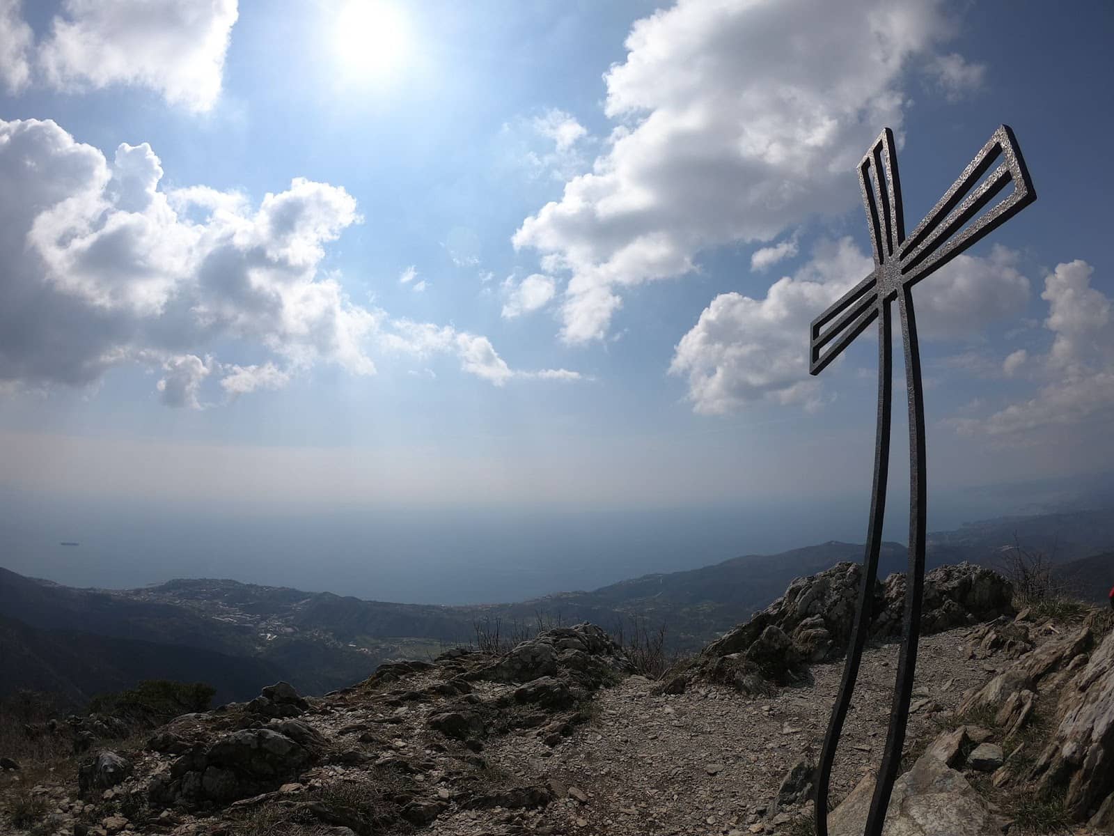
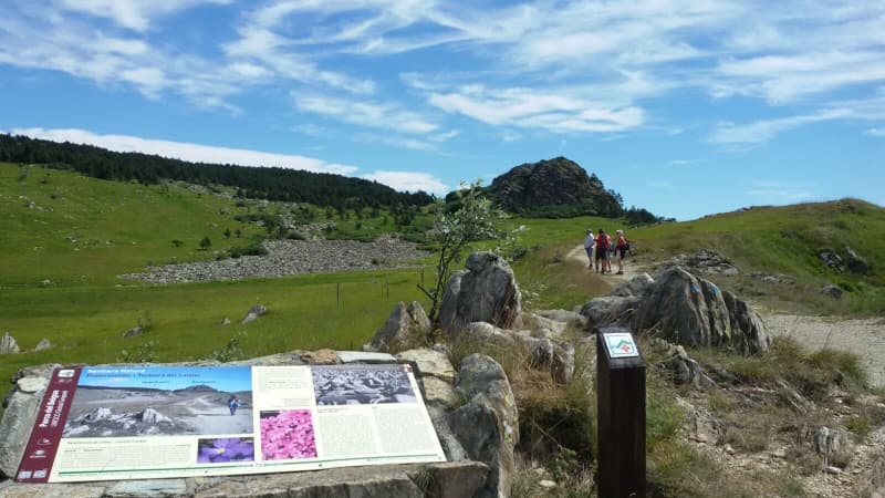
Summit Crosses
Summit
Reach the top for panoramic views and iconic summit crosses, a rewarding sight after your climb.
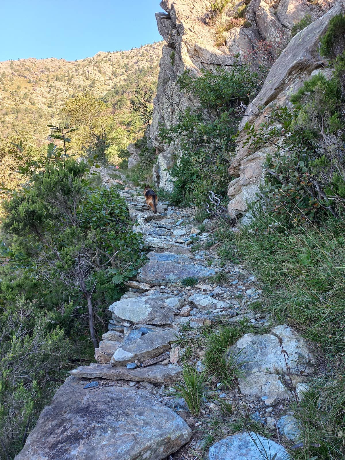
Via dell'Acqua
Ascent route
A challenging and exciting climbing route with rocky sections and beautiful natural features.
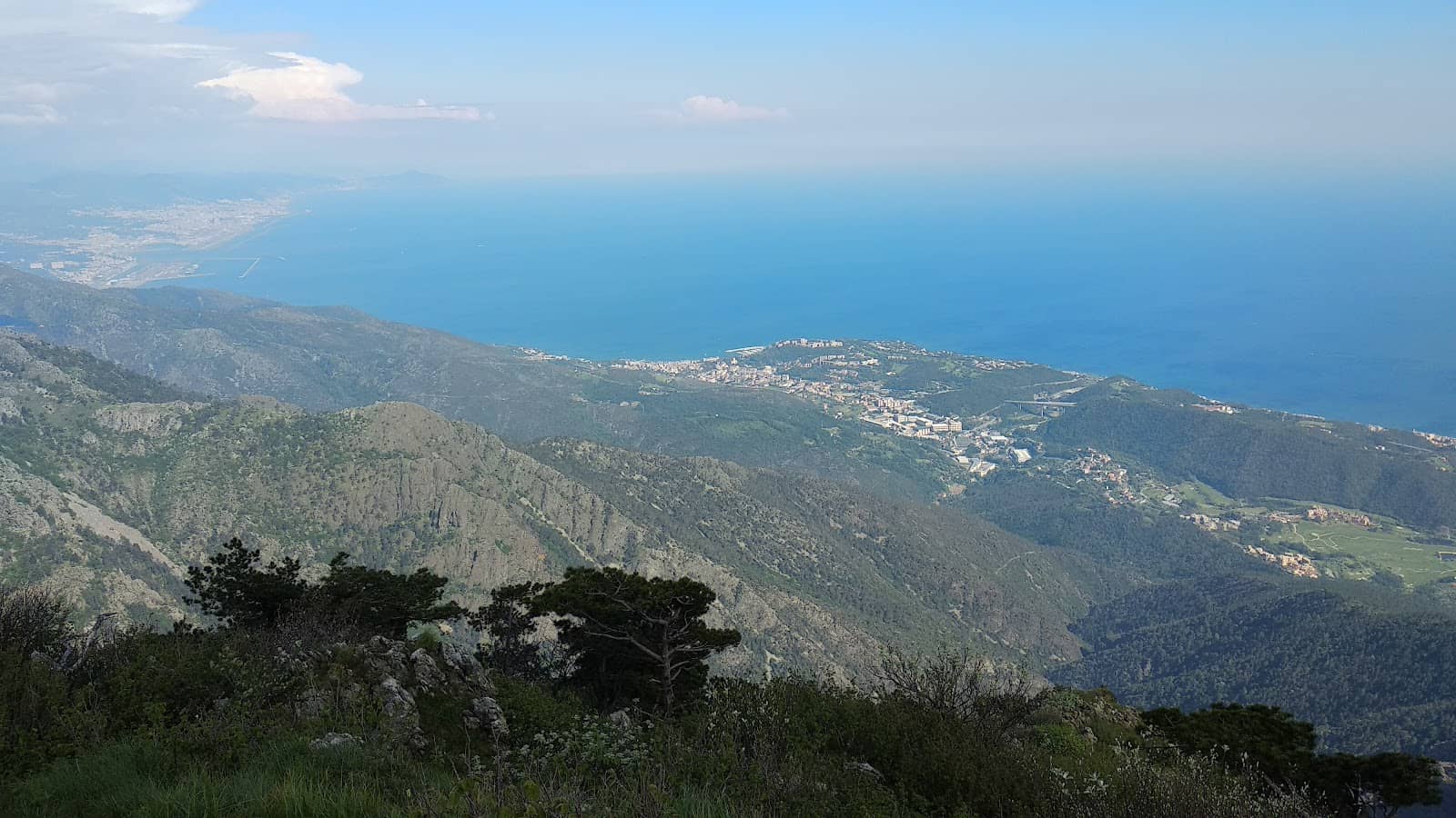
Panoramic Views
Summit
Breathtaking vistas of the Ligurian Sea and surrounding mountains await at the peak.
Ophiolitic Rocks & Blockfields
Beigua Regional Natural Park
Discover unique geological formations, including ophiolitic rocks and blockfields, within the park.
Plans like a pro.
Thinks like you
Planning Your Visit
Timing Your Ascent
Gear Up for the Summit
Best Times
Insider Tips
from TikTok, Instagram & Reddit
Choose Your Route Wisely
The 'direttissima' is for experienced hikers. The 'via dell'acqua' offers a thrilling climb. :hiking_boot:
Pack Climbing Gear
For challenging routes, bring a harness, helmet, rope, and slings. 🧗
Hydration is Key
There are springs along the way, but carry extra water. :water_wave:
Respect Nature
This area is a protected park; avoid leaving any trace. :evergreen_tree:
Tips
from all over the internet
Choose Your Route Wisely
The 'direttissima' is for experienced hikers. The 'via dell'acqua' offers a thrilling climb. :hiking_boot:
Pack Climbing Gear
For challenging routes, bring a harness, helmet, rope, and slings. 🧗
Hydration is Key
There are springs along the way, but carry extra water. :water_wave:
Respect Nature
This area is a protected park; avoid leaving any trace. :evergreen_tree:
Stunning Summit Views
The panoramic views from the top are worth the effort! :star2:
What Travellers Say
Reviews Summary
Monte Rama is praised for its breathtaking panoramic views and challenging, rewarding hiking routes, particularly the 'direttissima' and 'via dell'acqua'. The unique geological formations and natural beauty of the Beigua Regional Natural Park are significant draws. However, some find the more difficult trails demanding and advise caution.
"The trail begins in Lerca near the Chapel of Saint Anna. The climb is challenging at times, but to reach the top there's the "direttissima" route, which I recommend for fit people. It's the classic route that climbs to a section with jagged rocks that make the climb a bit challenging. On the way up, there's a spring. At the top, there are crosses and a beautiful view. Descending, you reach the crossroads of the Alta Via Monti Liguri, from which you can reach the Pratorotondo Monte Beigua refuge if you go left. If you go right, you reach the Argentea refuge, and then continue towards the Gava pass and descend to Arenzano. We descended towards Sciarborasca, which takes 2.5 hours, and we encountered a rich source of Montebello spring water. From Sciarborasca to Lerca, it's another 30 minutes, but on asphalt. IT WOULD BE A TRUE SACRILEGE TO ALLOW A MINE IN THIS PARADISE."
Silvia Resio
"A beautiful ride not to be underestimated. Elevation gain of +/- 1000 m. But the view makes up for the effort."
Luca Molteni
"It is located on a secondary ridge that branches off from the main Apennine watershed, at the pass between Bric Resonau and Rocca del Lago, and runs in an east-southeast direction, passing the Fontanaccia peak and continuing to the mountain's summit. From here, another ridge branches off, descending southward, climbing to the summit of Bric Camulà, from which it continues in a southeasterly direction until it ends near the hamlet of Lerca. The western and southern slopes are mostly barren, alternating between grassy expanses and rocky outcrops; the northern and eastern slopes, bordered by the Lerca Valley, are wooded with pine and beech trees. The summit is clearly visible from nearby coastal villages; from Cogoleto, the peak has a typical pyramidal shape, while from Arenzano, it has an almost perfect conical shape, along with the nearby Bric Camulà. Geologically, the mountain is a homogeneous mass of serpentinite and serpentinoschists, part of the Capanne di Marcarolo serpentine complex, which in turn belongs to the Voltri greenstone calcschists group, dating back to the Jurassic-Cretaceous period. Near Mount Bric Camulà, several calcium silicate beds (rodingites) emerge. The mountain is within the protected area of the Beigua Regional Natural Park. The slopes of Mount Rama and Bric Camulà offer several climbing routes of varying difficulty. Some lead to the summit, while others are more limited."
Lucio Parrini
What People Like
What People Dislike
Frequently Asked Questions
🚇 🗺️ Getting There
Exit the GE-SV at the Arenzano toll booth, head towards Savona, pass Colletta, and descend towards the sea. Turn right to reach Lerca village, then continue on a narrow road past the chapel of Sant'Anna and park after the golf course. Follow the path marked with 'two red lines'.
The trail often starts in Lerca, near the Chapel of Saint Anna. Parking is available after the new golf course.
Information on direct public transport is limited, but local buses may reach nearby villages like Lerca or Sciarborasca, requiring a walk to the trailhead.
The Alta Via Monti Liguri is a long-distance hiking trail network in the Ligurian Apennines. Monte Rama is accessible from its crossroads.
Yes, the Pratorotondo Monte Beigua refuge and the Argentea refuge are accessible from the Alta Via Monti Liguri crossroads near Monte Rama.
🎫 🎫 Tickets & Entry
No, hiking Monte Rama is generally free as it's located within the Beigua Regional Natural Park.
Monte Rama is an outdoor natural attraction, so it's accessible at all times. However, it's best to hike during daylight hours for safety.
Access to the Beigua Regional Natural Park is typically free, though specific facilities within the park might have charges.
While not always advertised, local guides or park authorities might offer guided tours, especially for specific geological or historical aspects. Inquire locally.
As it's a protected natural park, visitors are expected to respect the environment, stay on marked trails, and avoid littering.
🎫 🥾 Onsite Experience
The difficulty varies greatly by route. The 'direttissima' is challenging (AD-), while other routes like the one from Pratorotondo are easier.
The duration depends on the chosen route and your fitness level. Some ascents can take 2-3 hours, while more challenging routes might take longer.
Expect a mix of grassy expanses, rocky outcrops, steep slopes, and wooded areas with pine and beech trees.
Yes, there are springs along the way, including the Montebello spring water. However, it's always wise to carry extra water.
This likely refers to the unique geological formations and ancient status mentioned in some social media posts, possibly related to the park's natural features.
📸 📸 Photography
The summit offers incredible panoramic views of the Ligurian Sea and mountains. The rocky sections of the 'via dell'acqua' also make for dramatic shots.
Early morning or late afternoon light provides beautiful golden hour illumination for landscape photography.
A wide-angle lens is great for capturing the expansive views. If you're into climbing photography, consider a versatile zoom lens.
Look for the unique ophiolitic rocks, blockfields, summit crosses, and the dramatic interplay of light and shadow on the slopes.
Drone usage may be restricted in natural parks. Always check local regulations and park rules before flying a drone.
Social
from TikTok, Instagram & Reddit