
Sentiero del Viandante Colico section
A historic trail along Lake Como's eastern shore, offering stunning views and charming villages, but demanding careful navigation.
Highlights
Must-see attractions

Social
From TikTok & Reddit
Best Time
Pleasant temperatures, fewer crowds
Sentiero del Viandante Colico section
Best Time
Pleasant temperatures, fewer crowds
Highlights
Must-see attractions
A historic trail along Lake Como's eastern shore, offering stunning views and charming villages, but demanding careful navigation.
"The views are breathtaking, but be prepared for confusing signage!"
Navigation is Key
Use a reliable hiking app; signage can be inconsistent. Don't rely solely on trail markers! :iphone:
Sturdy Footwear Essential
Stone steps can be slippery, especially after rain. Good hiking boots are a must. :athletic_shoe:
Highlights
Discover the most iconic attractions and experiences
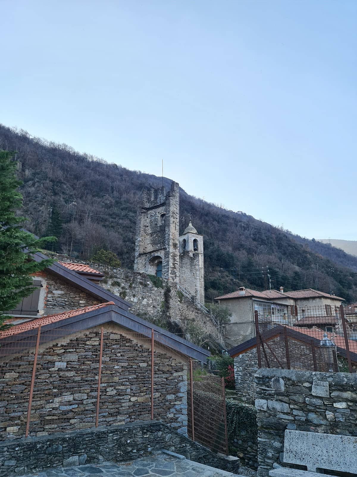
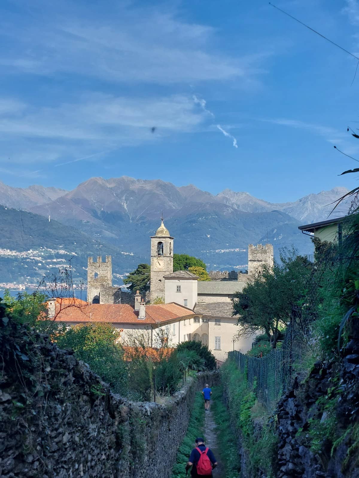
Corenno Plinio Castle
Near Dervio
Explore the medieval castle and the charming church of St. Thomas of Canterbury.
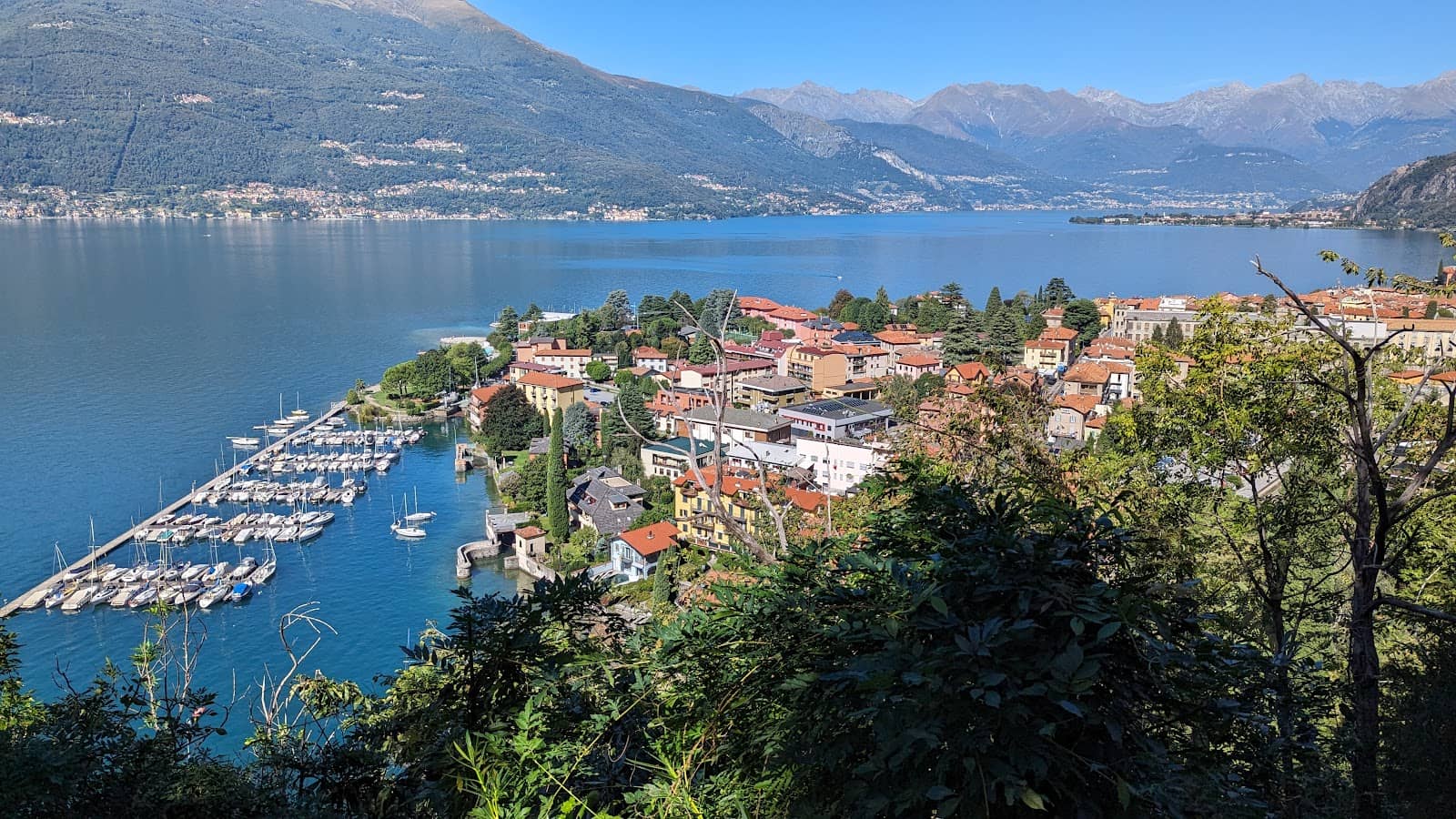
Dervio Historic Center
Dervio
Wander through narrow streets and enjoy splendid lake views in this delightful town.
Mondonico Hamlet
Between Dervio and Dorio
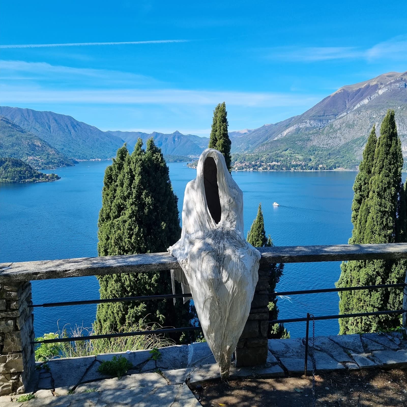
Discover the 'ghost town' of Mondonico, a unique stop on the trail.
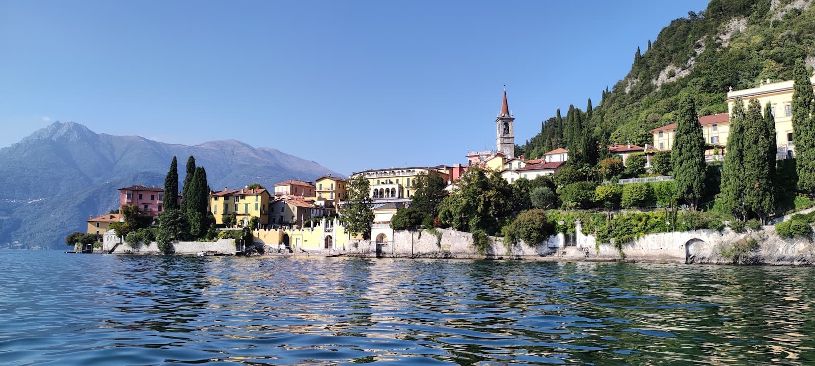
Views over Lake Como
Various points
Breathtaking panoramic vistas of Lake Como are a constant reward for your efforts.
Plans like a pro.
Thinks like you
Planning Your Visit
Signage Challenges
Footwear & Weather
Best Times
Insider Tips
from TikTok, Instagram & Reddit
Navigation is Key
Use a reliable hiking app; signage can be inconsistent. Don't rely solely on trail markers! :iphone:
Sturdy Footwear Essential
Stone steps can be slippery, especially after rain. Good hiking boots are a must. :athletic_shoe:
Pack Water & Snacks
Limited services on the trail. Stay hydrated and fueled for the hike. :water_wave:
Consider Train Travel
Parking can be difficult and paid. Arriving by train to Colico or Dervio is recommended. :train2:
Tips
from all over the internet
Navigation is Key
Use a reliable hiking app; signage can be inconsistent. Don't rely solely on trail markers! :iphone:
Sturdy Footwear Essential
Stone steps can be slippery, especially after rain. Good hiking boots are a must. :athletic_shoe:
Pack Water & Snacks
Limited services on the trail. Stay hydrated and fueled for the hike. :water_wave:
Consider Train Travel
Parking can be difficult and paid. Arriving by train to Colico or Dervio is recommended. :train2:
Check Weather Forecast
Rain can make the trail challenging and increase the risk of slips. :cloud_rain:
What Travellers Say
Reviews Summary
The Sentiero del Viandante Colico section is praised for its stunning lake views and charming historic villages. However, hikers frequently mention inconsistent and confusing trail signage, which can lead to navigation difficulties. The terrain can also be challenging, especially when wet.
"Colico-Dervio stop. 4 adults, 6 children aged 9 to 14, and a 4-month-old puppy. We arrived in Colico by train. From the station, we walked to San Rocco. We didn't find any signs; maybe there were, but we didn't see any. The hike from the station to the trailhead is an hour's uphill walk among luxurious villas and homes. We gain altitude. Then the trail begins. The first section, always well-marked and uphill, is on a dirt road with car access through chestnut woods. Then we reach villages like Sparesee, followed by Perdonasco and Dorio, all connected by a truly picturesque, pleasant, and scenic stone path. From Perdonasco, the trail begins to descend, with a significant elevation gain, and slowly we reach Dervio, where, with a final push, we reached our accommodation. Dervio is delightful, with a quaint and well-kept historic center, made up of narrow streets and steps, and splendid views of the lake.
Dervio-Varenna stop. Compared to the others, it's not very well marked, or we weren't paying attention. It intersects with the Giro dei Borghi, and the signage is confusing. We even got lost and had to turn back. It also has a different road route (perhaps because we got lost?). Overall, it's quite challenging, with several ups and downs, mostly on stone steps. And if it rained, they can be slippery. The view makes up for the effort. We couldn't find accommodations we could afford in Varenna, so we took the train to a hotel in Mandello."
Fanny Locatelli
"5 of 5: Dervio - Colico Piano
Start from the Dervio train station and, after taking Via Martiri della Liberazione, enter Via Pietro Giglio, where the first signs begin. You pass through the small and charming historic center and, after a drinking fountain, you arrive at the ruins of Dervio Castle, including the beautiful Orezia Tower.
Despite the numerous signs ensuring you won't get lost, you continue for about 1 km, with the disturbing presence of the highway passing nearby before joining the dirt path.
A brief stop to visit the church of St. Thomas of Canterbury, nestled within the walls of the medieval castle of Corenno Plinio.
The trail sign is not well positioned, but you need to continue along the main road until the cemetery on Via Maronasso, where the trail resumes. Once you reach Dorio, you need to go to Via Panico (Panico) to resume the trail. An interesting stop is Mondonico, the so-called "ghost town," where the flat stretch ends and a long dirt road climb begins, culminating in Dorio
(here's another drinking water fountain). Two more small villages, Perdonasco and Sparesee, lead to the center of Colico and its train station, along a paved road that goes all the way downhill."
michele umer
"The Dervio/Colico section (from the Trekkinglecco website, medium difficulty) is 13.7km long with 530m of elevation gain. In fact, according to GPS data, we hiked 16km (to the Colico station) with nearly 700m of elevation gain. This was due to a ridiculous lack of signage at a fork after the hamlet of Mandonico: from there, we took the wrong turn, marked in orange like the entire Sentiero del Viandante (!!!!), which, after over 4km of steady ascent, led us to the hamlet of Monte Piazzo. This route is classified as a difficult trail, but in reality, it is extremely difficult. It winds through rocks, brush, and challenging sections that should be marked in advance to avoid endangering the safety of unprepared hikers and even children. It was only thanks to the specific app available on the Trekkinglecco website that we were able to correct and direct our route, but I believe this technology cannot and should not replace the trail signs, which must always be clear, timely, and logical for everyone.
What would happen if there was no signal, or if the smartphone failed or ran out of battery? Rating: 5"
Alberto 57
What People Like
What People Dislike
Frequently Asked Questions
🚇 🗺️ Getting There
The most convenient way is by train to Colico or Dervio stations. Parking in these towns can be limited and often paid, making train travel a preferred option for many hikers.
Access points vary. From Colico station, it's an uphill walk through villas to reach the trailhead. In Dervio, you start near the station and follow signs towards the castle.
Yes, but parking is often paid and can be scarce, especially during peak season. Arriving by train is generally advised to avoid parking hassles.
The train line runs along the lake, connecting towns like Colico, Dervio, and Varenna, making it easy to plan point-to-point hikes.
While the trail itself is for hiking, the train line offers excellent connectivity between the start and end points of different sections.
🎫 🎫 Tickets & Entry
No, the Sentiero del Viandante is a public hiking trail and does not require any tickets or admission fees.
The trail is open year-round, 24 hours a day. However, it's best to hike during daylight hours for safety and enjoyment.
Entry to the villages like Corenno Plinio or Dervio is free. Some individual attractions within these villages might have separate entrance fees, but the trail itself is free.
Yes, dogs are generally allowed on the trail, but they must be kept on a leash. Be mindful of other hikers and the terrain.
While there isn't a dedicated visitor center for the entire trail, local tourist information offices in towns like Colico or Dervio may offer maps and advice.
🎫 🥾 Onsite Experience
The Dervio to Colico section is approximately 13.7km and can take around 6 hours of walking, though some report it taking closer to 3-4 hours with fewer stops.
It's generally considered medium difficulty, with some challenging uphill sections and slippery stone steps. Proper footwear is crucial.
Absolutely! The trail offers numerous stunning viewpoints overlooking Lake Como, making the effort worthwhile.
Expect a mix of dirt roads, paved paths, and historic stone mule tracks. Some sections are steep and can be challenging.
Signage can be inconsistent. While some parts are clearly marked, others can be confusing, so having a navigation app is highly recommended.
🍽️ 🍎 Food & Dining
Options are limited directly on the trail. You'll find more choices in the villages like Dervio and Colico. Some reviews mention restaurants like Posallo.
Yes, some reviews mention finding drinking water fountains in villages like Mondonico and Dorio, but it's wise to carry your own water.
Dervio has a quaint historic center with restaurants and cafes offering local cuisine. It's a good place to refuel after or before your hike.
Packing a picnic is a great idea, especially if you plan to stop and enjoy the scenic viewpoints. It gives you flexibility.
Traditional Italian cuisine often includes vegetarian options. For vegan choices, it's best to inquire at restaurants in the towns.
📸 📸 Photography
Look for elevated viewpoints overlooking Lake Como, charming stone villages like Corenno Plinio, and the historic ruins of Dervio Castle.
Golden hour, shortly after sunrise or before sunset, offers beautiful light for landscape shots of the lake and villages.
A smartphone camera is usually sufficient for capturing the beauty. If you're serious about photography, a DSLR or mirrorless camera with a wide-angle lens would be ideal.
The 'ghost town' of Mondonico, the Orezia Tower in Dervio, and the ancient stone paths offer unique and atmospheric photo opportunities.
Inconsistent signage can lead to unexpected routes, and slippery conditions after rain can make it tricky to maneuver with camera gear.
For Different Travelers
Tailored advice for your travel style
👨👩👧 Families with Kids
Key considerations for families:
* Footwear: Ensure children have sturdy, comfortable hiking shoes, as the trail includes stone steps that can be slippery.
* Navigation: Be extra vigilant with signage, as getting lost can be stressful with kids. A reliable navigation app is a must.
* Pacing: Break the hike into shorter segments, utilizing villages for rest stops. Consider hiking only a portion of the trail if a full day hike is too much.
* Snacks & Water: Pack plenty of food and drinks, as amenities are sparse.
🚶 Budget Travelers
Tips for budget travelers:
* Travel by Train: Utilize the train line connecting Colico, Dervio, and Varenna. It's often more economical than parking fees and offers flexibility.
* Pack Your Own Food: Bring a picnic lunch and snacks to avoid expensive restaurant meals. Water fountains are available in some villages, but carrying your own water is advisable.
* Accommodation: Look for budget-friendly guesthouses or hostels in towns further from the most popular tourist spots, or consider camping if available and permitted.
📸 Photography Enthusiasts
Photography tips:
* Golden Hour: Aim to hike during the early morning or late afternoon for the best natural light, which enhances the colors and textures of the landscape and villages.
* Village Details: Don't just focus on the grand views; capture the intricate details of the stone paths, historic buildings in Dervio, and the unique atmosphere of Mondonico.
* Wide-Angle Lens: A wide-angle lens will be useful for capturing the expansive lake views, while a prime lens can be great for village details or portraits.
* Be Prepared for Conditions: The trail can be uneven and slippery, so ensure your gear is protected, especially if shooting in wet conditions.
Deep Dives
In-depth insights and expert knowledge
Navigating the Sentiero del Viandante
To ensure a smooth experience, it's highly recommended to supplement the physical signage with a reliable navigation app on your smartphone. Apps like Komoot or AllTrails, which often have offline maps, can be invaluable. Many users have found these digital tools essential for correcting their course when physical markers are absent or misleading. Always ensure your device is fully charged and consider carrying a portable power bank.
Despite the signage issues, the trail itself is rewarding. It traverses through chestnut woods, past charming hamlets like Sparesee, Perdonasco, and Dorio, and offers picturesque stone paths. The historical villages, such as Corenno Plinio with its castle, provide fascinating glimpses into the past. The key is to be prepared for the navigational challenges and to enjoy the scenic journey.
The Charm of Lake Como Villages
Further along, you'll encounter hamlets like Sparesee and Perdonasco, connected by scenic stone paths. These smaller settlements offer a glimpse into traditional lakeside life. A particularly intriguing stop is Mondonico, often referred to as a 'ghost town.' This unique location adds a layer of mystique to the hike and is a memorable point of interest.
These villages are not just picturesque stops; they are integral to the experience of the Sentiero del Viandante. They break up the hike, offer opportunities for rest and refreshment, and provide a rich cultural context to the natural beauty of the surrounding landscape. Exploring these historic hamlets is as much a part of the adventure as the trek itself.
Safety and Preparation for the Trail
Beyond footwear, carrying adequate supplies is crucial. While some villages offer amenities, direct access to water and food on the trail itself is limited. Hikers are strongly advised to carry sufficient water and snacks to stay hydrated and energized throughout their journey. Checking the weather forecast before setting out is also a non-negotiable step, as conditions can change rapidly in the mountains.
Finally, the issue of signage cannot be overstated. While the trail is generally marked, the inconsistency means that hikers should be prepared for potential navigation challenges. Having a map, a compass, or a reliable GPS device or app is a wise precaution. Being aware of these factors will significantly enhance the safety and enjoyment of your hike on the Sentiero del Viandante.


Social
from TikTok, Instagram & Reddit