
Mweelrea Mountain
Connacht's highest peak, Mweelrea offers a challenging hike with breathtaking panoramic views of the Atlantic coast and surrounding mountains.
Highlights
Must-see attractions

Social
From TikTok & Reddit
Best Time
Best chance for clear skies
Mweelrea Mountain
Best Time
Best chance for clear skies
Highlights
Must-see attractions
Connacht's highest peak, Mweelrea offers a challenging hike with breathtaking panoramic views of the Atlantic coast and surrounding mountains.
"Out of all my hikes in Ireland, I’d recommend this one the most."
🎒 Pack Smart
Bring layers, waterproofs, sturdy boots, plenty of food & water. Phone fully charged!
⚠️ Don't Underestimate
Mweelrea is challenging. Be prepared for steep, boggy terrain and rapid weather changes.
Quick Facts
Rating
4.8 · 73 reviews
Type
Natural Feature
Highlights
Discover the most iconic attractions and experiences
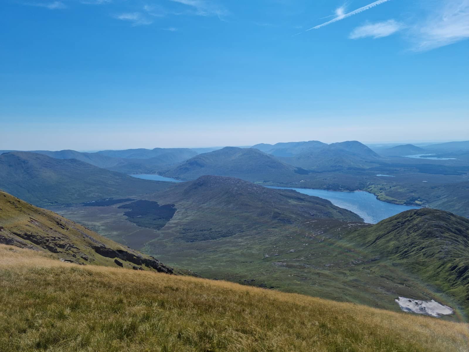
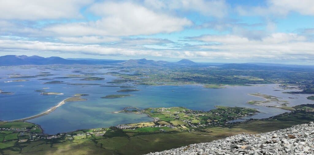
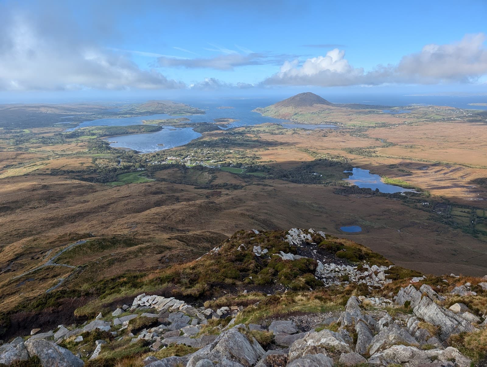
Summit Views
Mweelrea Summit
Panoramic vistas of Clew Bay, Connemara, and the Atlantic Ocean. Truly breathtaking!
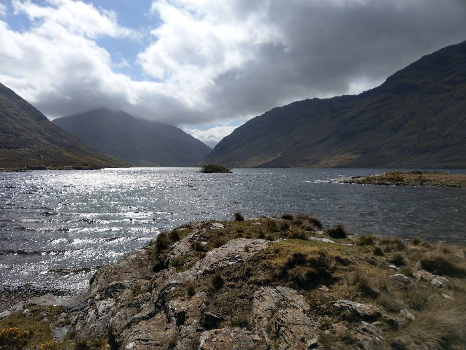
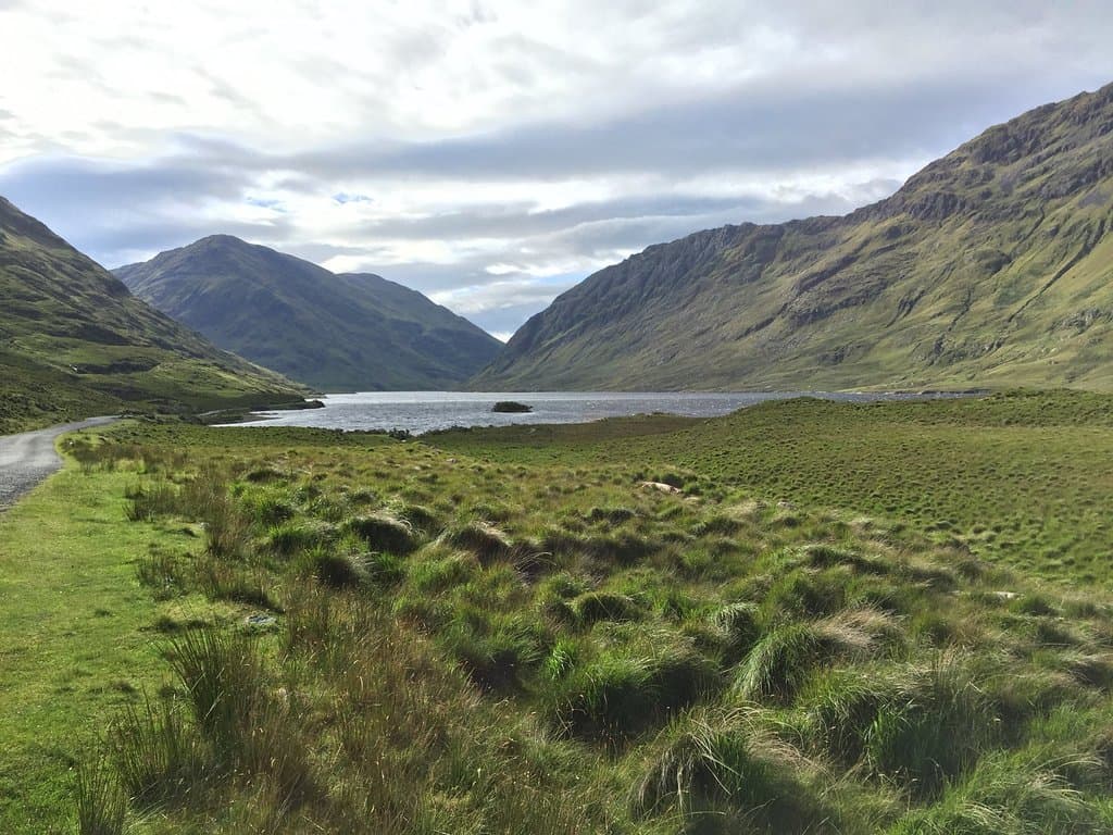
Doo Lough Valley Approach
Doo Lough Valley
A challenging but rewarding route with dramatic glacial valley scenery.
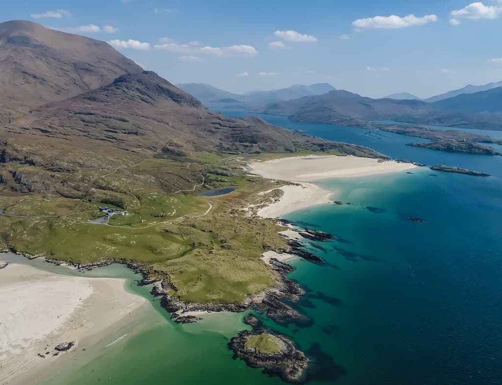
Silver Strand Ascent
Silver Strand
A popular starting point offering a more direct, though sometimes boggy, path to the summit.
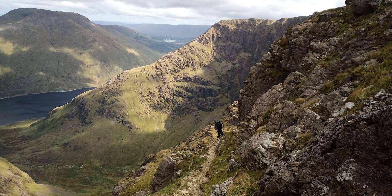
The Ramp
Northeastern Glacial Corrie
A thrilling, natural 'ramp' offering a unique and challenging way to ascend the mountain.
Plans like a pro.
Thinks like you
Planning Your Visit
Prepare for a Challenging Climb
Weather is Key
Best Times
Insider Tips
from TikTok, Instagram & Reddit
🎒 Pack Smart
Bring layers, waterproofs, sturdy boots, plenty of food & water. Phone fully charged!
⚠️ Don't Underestimate
Mweelrea is challenging. Be prepared for steep, boggy terrain and rapid weather changes.
🗺️ Route Planning
Consider the 'ramp' and ridgeline traverse for a more adventurous experience.
🚗 Parking
Park at Silver Strand or roadside; be mindful of local access.
Tips
from all over the internet
🎒 Pack Smart
Bring layers, waterproofs, sturdy boots, plenty of food & water. Phone fully charged!
⚠️ Don't Underestimate
Mweelrea is challenging. Be prepared for steep, boggy terrain and rapid weather changes.
🗺️ Route Planning
Consider the 'ramp' and ridgeline traverse for a more adventurous experience.
🚗 Parking
Park at Silver Strand or roadside; be mindful of local access.
📸 Capture the Views
Stunning panoramic views await! Bring your camera for unforgettable shots.
What Travellers Say
Reviews Summary
Mweelrea Mountain is lauded as one of Ireland's most beautiful and rewarding hikes, offering unparalleled panoramic views from its summit. Hikers praise the challenging yet spectacular routes, particularly the 'ramp' and ridgeline traverses. However, visitors consistently warn of the demanding nature of the climb, the potential for boggy terrain, and the necessity of being prepared for rapidly changing and harsh weather conditions.
"It's one of the most beautiful hikes in Ireland.
You can park at the beach or roadside and make your way up through the fields to get to the base of Mweelrea.
About half way up, you'll come across a well-defined track to the top of Mweelrea.
The views are amazing, and if you've got the energy, I'd recommend hiking over to Benn Lugmore.
This is a tough hike, so expect to huff and puff.
Bring plenty of food, water, extra layers, and a fully charged phone.
Best of luck."
Adrian Toye
"Cascades of water flow like arteries. Moisture clings to you as if it’s a living entity, grabbing your boots and pulling them out from beneath you. Each step is sluggish. Each breath is labored. The elevation increases quickly. But despite the hard-fought terrain, hiking Mweelrea provides some of the most unique landscapes and one of the most rewarding summits. Out of all my hikes in Ireland, I’d recommend this one the most.
Beware, though. This isn’t for the faint of heart. It’s about 12 miles (19 kilometers) and boasts about 2,700 feet (814 meters) of elevation gain. Bring proper clothes for the weather will change in an instant, and bring food and lots of water."
Cullan McNamara
"Fantastic hike we went up Silver Strand way as we started late 5.30 , a bit boggy up to half way , misty on the way up but stunning views from the top, a cloud inversion on one side and blue skies on the Killary side"
Paul Savage
What People Like
What People Dislike
Frequently Asked Questions
🚇 🗺️ Getting There
Mweelrea is located in southwest County Mayo. The most common starting points are near Silver Strand on the western side or from the Doo Lough Valley on the eastern side. Access is typically by car, with parking available at Silver Strand or roadside pull-offs. +1
Many hikers choose the route from Silver Strand for a more direct ascent. For a more challenging and scenic experience, consider starting from the Doo Lough Valley, which includes the dramatic 'ramp'. +1
Public transport options to the immediate vicinity of Mweelrea are very limited. It is best accessed by private vehicle.
Parking is available at Silver Strand, though it can get busy. Other roadside parking spots are also used, but be sure to park considerately and avoid blocking local access.
Mweelrea Mountain is approximately a 1-hour drive southwest of Westport, County Mayo.
🎫 🎫 Tickets & Entry
No, Mweelrea Mountain is a natural landscape and does not require tickets for access. It's free to hike.
Mweelrea is accessible at all times. However, hiking in the dark is not recommended due to safety concerns and the challenging terrain.
There is no entrance fee to hike Mweelrea Mountain. It is a public access area.
Yes, several local guides and hiking companies offer guided hikes up Mweelrea, which can be beneficial for navigating the challenging routes and understanding the local environment.
The best time to visit is generally during the summer months (June-August) for the highest chance of good weather. However, spring and autumn can offer fewer crowds and beautiful scenery, provided you are prepared for variable conditions.
🎫 ⛰️ Onsite Experience
A typical hike up and down Mweelrea can take anywhere from 5 to 8 hours, depending on your fitness level, the chosen route, and the weather conditions. Some hikers complete it in around 6.5 hours.
Mweelrea is considered a challenging hike. It involves significant elevation gain, steep ascents, and potentially boggy or rocky terrain. It's not recommended for beginners or those not prepared for strenuous activity.
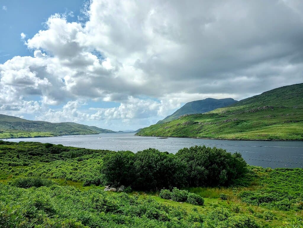
The views from the summit are spectacular and often described as breathtaking. You can see Clew Bay, the Twelve Bens, the Maamturks, and islands off the west coast on a clear day. +1
Facilities are minimal. Parking is usually the main amenity. There are no visitor centers, restrooms, or shops directly at the trailheads.
Solo hiking is possible, but given the challenging nature and potential for unpredictable weather, it's advisable to inform someone of your plans, carry a fully charged phone, and be well-prepared.
📸 📸 Photography
The summit offers incredible panoramic views. The approach through Doo Lough Valley and the glacial corrie also provide dramatic landscapes. Silver Strand beach at the base is also picturesque. +2
Early morning or late afternoon can offer beautiful light, especially during sunrise or sunset. However, clear midday conditions provide the best visibility for expansive views.
A wide-angle lens is great for capturing the vast landscapes. A telephoto lens can be useful for distant features. A sturdy tripod is helpful for low-light conditions or long exposures.
Yes, drone footage can capture stunning aerial perspectives of the mountain, the surrounding fjords, and the coastline. Always check local drone regulations before flying. +1
While clear skies offer the best visibility, moody, misty conditions can create dramatic and atmospheric photographs, especially with cloud inversions.
Social
from TikTok, Instagram & Reddit