
Needle Peak Trail
Conquer the challenging Needle Peak Trail for breathtaking summit views and an unforgettable alpine adventure in British Columbia.

Highlights
Must-see attractions

Social
From TikTok & Reddit
Best Time
Clear skies, best views
Needle Peak Trail
Best Time
Clear skies, best views
Highlights
Must-see attractions
Conquer the challenging Needle Peak Trail for breathtaking summit views and an unforgettable alpine adventure in British Columbia.
"Amazing hike up to Yak Peak! Not for the faint hearted, but great views once you get to the top."

👟 Sturdy Hiking Boots Needed
Essential for steep, rocky terrain and potential scrambles. Good grip is key!
💧 Bring Ample Water
There are no water sources on the trail; carry enough for the entire hike.

Highlights
Discover the most iconic attractions and experiences
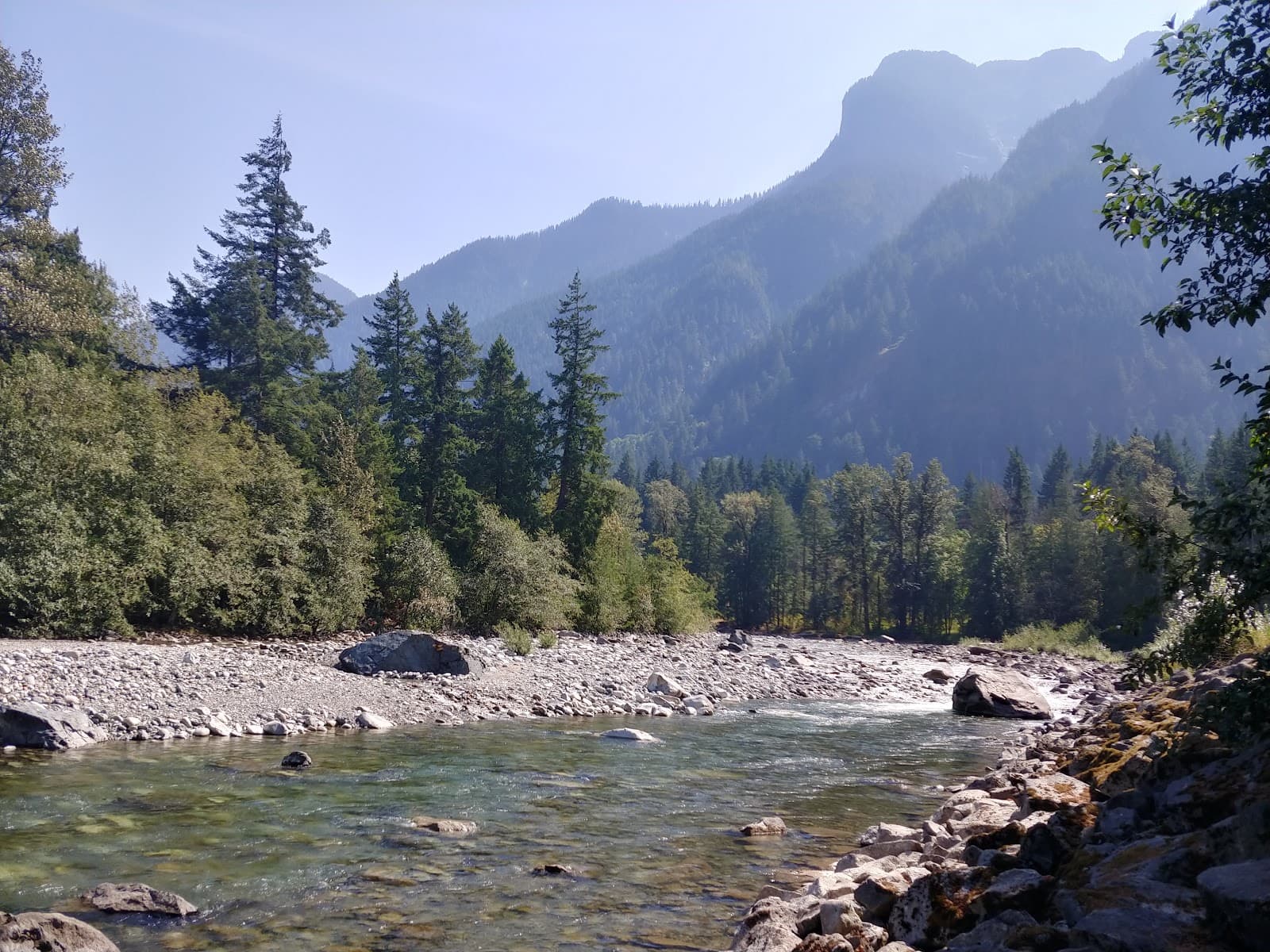
Yak Peak Summit
Summit of Yak Peak
Reach the top for breathtaking 360-degree panoramic views of the surrounding mountains and valleys.
The Flatiron
Near Needle Peak Trail
A prominent rock formation offering stunning vistas and a rewarding destination for hikers.

Steep Forest Ascent
Lower sections of the trail
Experience a challenging climb through dense forest, building anticipation for the open summit views.
Plans like a pro.
Thinks like you
Planning Your Visit
Prepare for a Challenging Ascent
Consider the Season and Conditions
Best Times
Insider Tips
from TikTok, Instagram & Reddit
👟 Sturdy Hiking Boots Needed
Essential for steep, rocky terrain and potential scrambles. Good grip is key!
💧 Bring Ample Water
There are no water sources on the trail; carry enough for the entire hike.
⬆️ Prepare for Steep Sections
The trail is demanding with significant elevation gain. Fitness is crucial.
🧗 Scramble at the End
The final approach involves a class 3 scramble; a rope might be needed.
Tips
from all over the internet
👟 Sturdy Hiking Boots Needed
Essential for steep, rocky terrain and potential scrambles. Good grip is key!
💧 Bring Ample Water
There are no water sources on the trail; carry enough for the entire hike.
⬆️ Prepare for Steep Sections
The trail is demanding with significant elevation gain. Fitness is crucial.
🧗 Scramble at the End
The final approach involves a class 3 scramble; a rope might be needed.
☀️ Check Weather Forecast
Conditions can change rapidly; be prepared for sun, rain, or even snow.
What Travellers Say
Reviews Summary
Hikers rave about the absolutely gorgeous scenery and rewarding 360-degree views from the summit of Yak Peak. It's described as an epic and adventurous day, perfect for getting away from city life. However, many caution that it's a strenuous, steep hike not for the faint-hearted, requiring good fitness, sturdy shoes, and potentially a rope for the scramble.
"Amazing hike up to yak peak! Not for the faint hearted. Hiking poles, good shoes and good fitness will make the hike less challenging.. about a 1km walk for the parking area along the coquihalla highway. And great views once you get to the top with multiple 360 view points all around you. On a clear day it’s a perfect hike to accomplish!"
avinash ferreira
"Wow!!! Great little rest area and the information they put up about the different trips you can do around the province. Wish I seen six months ago. Spent six months up and down the Ogangan valley.. Next summer! Oh my ya make sure you bring water, can't drink the water."
Andrew William Bartlett
"I did the hike up to flatiron and camped , steep incline but well worth it when you get to the top . Clean grounds and small tent spots near small lake ."
Bruce Davis
What People Like
What People Dislike
Frequently Asked Questions
🚇 🗺️ Getting There
Needle Peak Trail is located in the Coquihalla Summit Recreation Area in British Columbia. Access is typically via the Coquihalla Highway (Hwy 5). There's a parking area about 1 km from the trailhead along the highway. +1
Yes, there is a parking area for the trailhead. It's important to note that it's about a 1 km walk from the main Coquihalla Highway pull-off to the actual start of the trail.
While possible with snowshoes and proper winter gear, the trail can be very challenging and potentially dangerous in winter due to snow and avalanche risk. Check conditions carefully.
The closest major city is Hope, British Columbia, which is a significant drive away. Vancouver is also a common starting point for a road trip to this area.
The trailhead area is generally basic, with a parking lot. Information boards about local trips might be available at rest areas nearby.
🎫 🎫 Tickets & Entry
Typically, no permit is required for day hiking on Needle Peak Trail. However, if you plan to camp, you may need backcountry permits depending on the specific regulations.
Needle Peak Trail is an outdoor natural attraction and is generally accessible year-round during daylight hours. However, accessibility and safety can be significantly impacted by weather and snow conditions.
There is no entrance fee to access Needle Peak Trail for day hiking. It's a natural trail within a recreation area.
As there are no tickets required for day hiking, you don't need to purchase them in advance. It's best to plan your visit based on weather and trail conditions.
No advance booking is necessary for day hiking. For camping, check with BC Parks or relevant authorities for reservation requirements.
🎫 🧭 Onsite Experience
Needle Peak Trail is considered hard. It involves a steep incline through the forest and a challenging class 3 scramble at the end. Good fitness is required. +1
The hike typically takes between 5 to 7 hours roundtrip, depending on your fitness level and how long you spend at the summit. Some have completed it faster, around 2 hours to summit Yak Peak.
Expect a steep ascent through forest, rocky sections, and a significant scramble near the summit. The trail can be slippery if wet.
Yes, the trail offers increasingly spectacular views as you ascend, culminating in panoramic 360-degree vistas from the summit.
No, Needle Peak Trail is generally not recommended for beginners due to its steepness, length, and the technical scramble at the end. Moderate to advanced hikers are better suited.
🍽️ 🍽️ Food & Dining
No, there are no food services or restaurants directly on Needle Peak Trail. You must bring all your own food and water.
You can certainly picnic at the trailhead or find a suitable spot along the trail to enjoy your packed lunch. Remember to pack out all your trash.
You'll need to drive back towards Hope or other nearby towns for dining options. There are no immediate facilities at the trailhead.
It is not recommended to drink water directly from streams on Needle Peak Trail without proper filtration or purification, as it can contain contaminants.
Pack high-energy snacks like trail mix, energy bars, and sandwiches. Ensure you have plenty of water, as it's a strenuous hike.
📸 📸 Photography
The summit offers incredible panoramic views, especially on a clear day. The rocky formations and the challenging ascent also make for dramatic shots. +1
Early morning or late afternoon light can provide beautiful golden hour shots. Midday can be harsh but still offers stunning vistas.
A smartphone camera is sufficient for capturing the views, but a DSLR or mirrorless camera will offer more flexibility for landscape photography.
Drone usage is often restricted in national and provincial parks. Check the specific regulations for Coquihalla Summit Recreation Area before flying a drone.
Experiment with different angles from the trail leading up to it, and from the summit looking down. The scale of the rock formation is impressive.
For Different Travelers
Tailored advice for your travel style
👨👩👧 Families with Kids
If you're looking for a family-friendly hike in the Coquihalla area, consider exploring less demanding trails or opting for shorter walks with scenic viewpoints that don't involve significant elevation or scrambling. Always prioritize safety and choose hikes that match your children's abilities and endurance levels.
💰 Budget Travelers
Your primary expenses will be transportation to the trailhead and any food or water you pack. Since there are no facilities on the trail, bringing your own supplies is essential and cost-effective. This hike offers a high reward for minimal financial outlay, provided you have the necessary gear.
💑 Couples and Adventurous Pairs
Consider packing a picnic to enjoy at the summit or a scenic spot along the trail. The sense of achievement after completing the scramble and taking in the expansive vistas is a perfect way to celebrate your partnership. Remember to coordinate your efforts and support each other through the tougher sections of the hike.
Deep Dives
In-depth insights and expert knowledge
Navigating the Ascent: Trail Conditions and Difficulty
Hikers consistently describe the trail as strenuous, requiring good physical fitness and endurance. The elevation gain is significant, with some sources citing around 850m to over 2000m depending on the exact route and summit targeted.
While the views are spectacular, the trail is not for the faint of heart or inexperienced hikers. It's crucial to assess your capabilities honestly before embarking on this adventure. Checking recent trail reports for conditions, especially regarding snow or ice, is highly advisable.
Summit Views and Camping Options
For those looking to extend their experience, there are camping opportunities near the trail. One reviewer mentioned camping near a small lake, finding clean grounds and small tent spots.
When planning your visit, consider the time of day for the best photographic light. Early mornings and late afternoons offer softer, more dramatic lighting for capturing the grandeur of the landscape.
Seasonal Considerations and Safety
However, even in summer, mountain weather can be fickle. Be prepared for rapid changes, including rain, wind, and cooler temperatures at higher elevations. Checking the forecast immediately before your hike is essential.
During spring and fall, the trail can be more challenging due to lingering snow, ice, or early snowfall. Winter hiking is possible but requires advanced skills, appropriate gear (like snowshoes or skis), and a thorough understanding of avalanche risks. Some Reddit users have noted that the trail can be very slippery if wet, emphasizing the need for caution regardless of the season.


Social
from TikTok, Instagram & Reddit