
Sunshine Coast Trail BC
A rugged 180km point-to-point trail through BC's coastal rainforest, featuring volunteer-maintained huts and stunning ocean vistas.
Highlights
Must-see attractions

Social
From TikTok & Reddit
Best Time
Best light for photos
Sunshine Coast Trail BC
Best Time
Best light for photos
Highlights
Must-see attractions
A rugged 180km point-to-point trail through BC's coastal rainforest, featuring volunteer-maintained huts and stunning ocean vistas.
"Save this post for your next adventure to Powell River on the Sunshine Coast!"

Book Ferries in Advance
Secure your BC Ferries spots early, especially during peak season, to avoid long waits. ⛴️
Hut Etiquette is Key
Huts are first-come, first-served. Donate to qPAWS to support maintenance. :housewithgarden:

Quick Facts
Rating
5 · 1 reviews
Highlights
Discover the most iconic attractions and experiences

Tin Hat Hut
Near Powell River
A unique, iconic hut offering incredible views. A must-see on the Sunshine Coast Trail.
Sarah Point Trailhead
Near Powell River
The official starting point for many thru-hikers, accessible by water taxi for a true wilderness entry.
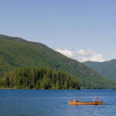
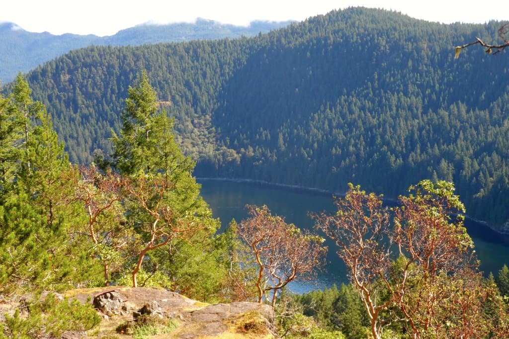
Coastal Vistas
Various points along the trail
Breathtaking ocean panoramas and lush rainforest scenery await at numerous viewpoints.
Plans like a pro.
Thinks like you
Planning Your Visit
Embrace the Wild: Prepare for a True Backcountry Experience
Logistics are Key: Ferries, Roads, and Water Taxis
Best Times
Insider Tips
from TikTok, Instagram & Reddit
Book Ferries in Advance
Secure your BC Ferries spots early, especially during peak season, to avoid long waits. ⛴️
Hut Etiquette is Key
Huts are first-come, first-served. Donate to qPAWS to support maintenance. :housewithgarden:
Pack for All Weather
BC coast weather is unpredictable. Layers are essential for comfort and safety. ☁️
Water Taxi to Sarah Point
Consider a water taxi for a scenic and efficient start to your thru-hike. ⛵
Tips
from all over the internet
Book Ferries in Advance
Secure your BC Ferries spots early, especially during peak season, to avoid long waits. ⛴️
Hut Etiquette is Key
Huts are first-come, first-served. Donate to qPAWS to support maintenance. :housewithgarden:
Pack for All Weather
BC coast weather is unpredictable. Layers are essential for comfort and safety. ☁️
Water Taxi to Sarah Point
Consider a water taxi for a scenic and efficient start to your thru-hike. ⛵
Download Offline Maps
Cell service is spotty. Ensure you have offline maps for navigation. :iphone:
What Travellers Say
Reviews Summary
The Sunshine Coast Trail is lauded for its stunning coastal scenery and challenging, rewarding hikes, particularly the iconic Tin Hat Hut. While the volunteer-maintained huts and the sense of wilderness are major draws, visitors note the significant logistical planning required, including ferry schedules and potential logging road access. Some find the trail demanding and the huts basic, but overall, it's a highly recommended BC adventure.
""
kairobbin zhou
What People Like
What People Dislike
Frequently Asked Questions
🚇 🗺️ Getting There
Accessing the Sunshine Coast Trail BC often involves multiple BC Ferries journeys, typically from Horseshoe Bay to Langdale, and then potentially another ferry from Earls Cove to Saltery Bay. From Saltery Bay, you'll drive towards Powell River. Some hikers opt for a water taxi to Sarah Point, the official start of the trail, to bypass logging road access. +1
From Powell River, you can access various trailheads. A popular starting point for thru-hikers is Sarah Point, which is often reached via a water taxi. Other access points can be reached by driving on logging roads, so it's advisable to check current road conditions before heading out. +1
While a car is helpful for reaching trailheads and managing logistics, it's possible to access certain sections via water taxi or by arranging shuttle services. However, for the full point-to-point experience, a car or pre-arranged transport is generally recommended.
Getting to the Sunshine Coast Trail from Vancouver typically involves a ferry ride to the Sunshine Coast (around 40-50 minutes to Langdale), followed by a drive to your chosen trailhead. The entire journey, including ferry waits and driving, can take several hours depending on your final destination on the coast. +1
While not as common as for some other major trails, some local operators may offer shuttle services for hikers on the Sunshine Coast Trail. It's best to research and book these in advance, especially if you are planning a thru-hike and need transport between trail termini.
🎫 🎫 Tickets & Entry
The Sunshine Coast Trail itself is free to access. However, hikers are strongly encouraged to donate $5 per person per night to qPAWS (qathet Parks And Wilderness Society) to support trail maintenance and hut upkeep. This is a voluntary contribution but vital for the trail's future.
No, the huts on the Sunshine Coast Trail are on a first-come, first-served basis. Arrive early, especially during peak season, to secure a spot. Be prepared to camp if huts are full.
The Sunshine Coast Trail is open year-round. However, conditions can vary significantly with the seasons. Summer offers the most accessible hiking, while winter can bring snow and challenging conditions.
There is no official entrance fee for the Sunshine Coast Trail. The trail is maintained by volunteers and supported by donations. Your contribution to qPAWS is highly appreciated.
No specific permits are required to hike the Sunshine Coast Trail itself. However, if you plan to camp in designated backcountry areas outside of the huts, you may need to check local regulations for any backcountry camping permits.
🎫 🥾 Onsite Experience
The Sunshine Coast Trail features diverse terrain, including steep climbs, muddy sections, root-covered paths, and some flatter coastal stretches. Expect a challenging but rewarding hiking experience with significant elevation changes.
The Sunshine Coast Trail is approximately 180 kilometers (111 miles) long, making it a significant thru-hiking challenge. It's a point-to-point trail that can take anywhere from 7 to 14 days to complete, depending on your pace.
You might encounter various wildlife, including deer, black bears, and numerous bird species. It's important to be bear-aware, store food properly, and make noise while hiking to avoid surprising animals.
Many of the huts on the Sunshine Coast Trail have outhouses. However, facilities are basic and vary by location. Always be prepared to pack out all your trash and practice Leave No Trace principles.
Yes, several sections of the Sunshine Coast Trail are excellent for day hikes. Popular day hike destinations include the trail to Tin Hat Hut, which offers a rewarding experience without the commitment of a multi-day trek.
📸 📸 Photography
The Sunshine Coast Trail offers numerous stunning photographic opportunities. Look for dramatic coastal vistas, lush rainforest scenes, and unique structures like the Tin Hat Hut. Sunrises and sunsets can be particularly spectacular from elevated points. +1
Early mornings and late afternoons, often referred to as the 'golden hours,' provide the best light for photography, creating dramatic shadows and warm hues. Waking up early for a sunrise view is highly recommended.
While drones can capture incredible aerial perspectives, be aware of regulations regarding drone usage in parks and protected areas. Always check local bylaws and ensure you have permission if required.
For the Sunshine Coast Trail, a versatile setup is ideal. Consider a wide-angle lens for landscapes, a telephoto lens for wildlife, and a sturdy tripod for low-light conditions. A durable, weather-sealed camera body is also a good investment.
Tin Hat Mountain and its hut are incredibly photogenic, offering panoramic views. Many sections along the coast also provide breathtaking ocean backdrops that are perfect for capturing memorable shots. +1


Social
from TikTok, Instagram & Reddit