
Mount Benson Regional Park
A challenging Vancouver Island hike with rewarding panoramic views over Nanaimo and the Strait of Georgia.
Highlights
Must-see attractions

Social
From TikTok & Reddit
Best Time
Misty forest light & fewer crowds
Mount Benson Regional Park
Best Time
Misty forest light & fewer crowds
Highlights
Must-see attractions
A challenging Vancouver Island hike with rewarding panoramic views over Nanaimo and the Strait of Georgia.
"The panoramic view from the summit makes every step worthwhile!"

👟 Wear Sturdy Footwear
Trails can be steep and slippery, especially after rain. Good hiking boots are a must!
💧 Bring Plenty of Water
The hike is strenuous, so stay hydrated. Pack extra for longer treks.
Highlights
Discover the most iconic attractions and experiences
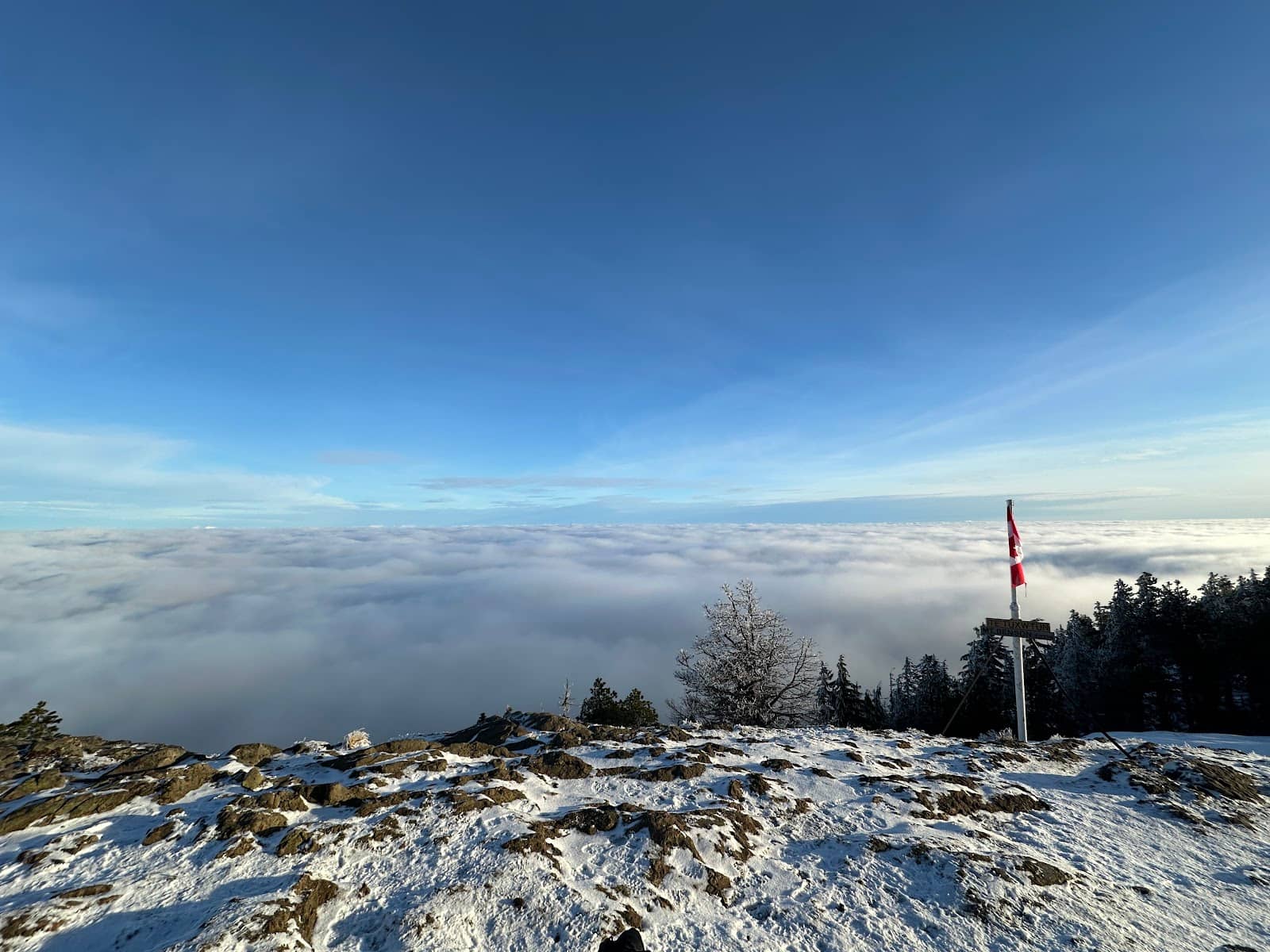
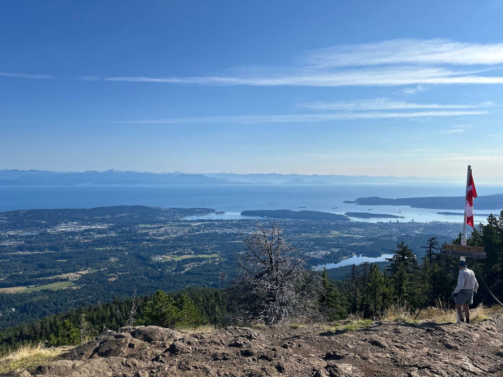
Summit Panorama
Mount Benson Summit
Breathtaking 360-degree views of Nanaimo, Departure Bay, and the Strait of Georgia.
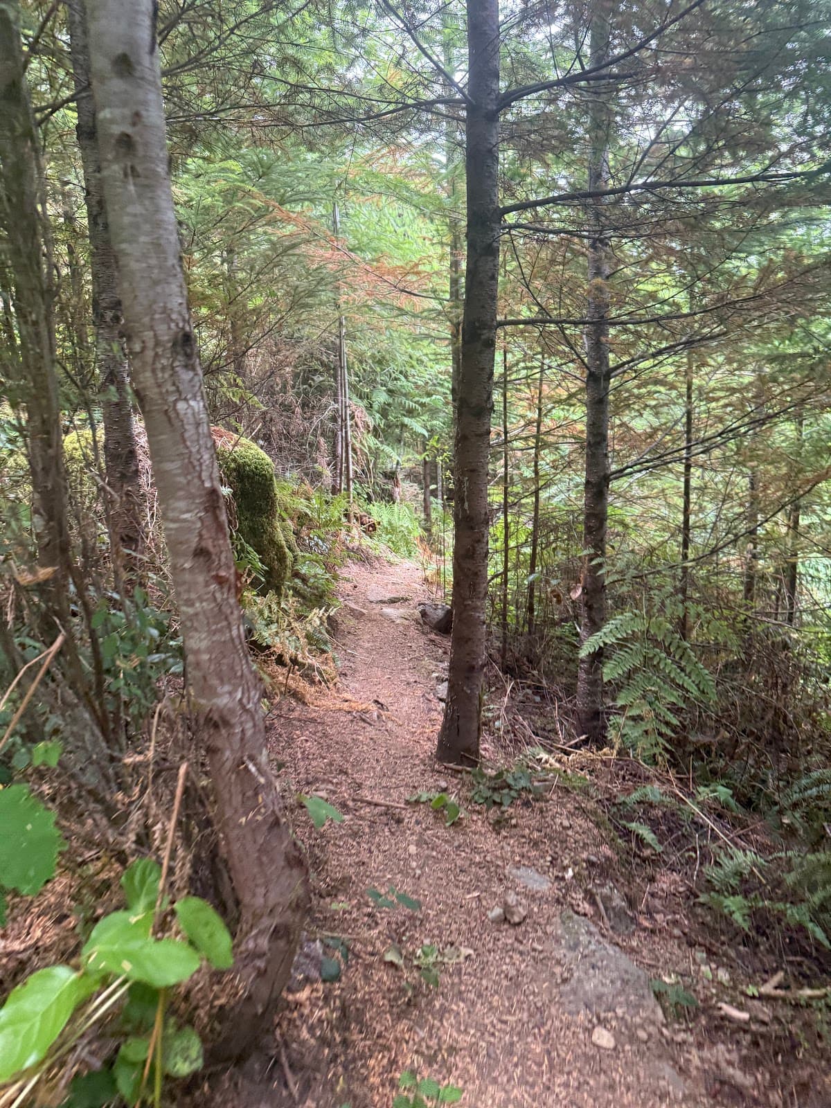
Mossy Forest Trails
Various trails
Winding paths through dense coastal forest with moss-covered rocks and tall firs.
Whiskey Jack Encounters
Mount Benson Summit
Friendly Whiskey Jacks (Gray Jays) might share your snacks at the top!
Plans like a pro.
Thinks like you
Planning Your Visit
Trail Difficulty & Timing
Getting to the Trailhead
Best Times
Insider Tips
from TikTok, Instagram & Reddit
👟 Wear Sturdy Footwear
Trails can be steep and slippery, especially after rain. Good hiking boots are a must!
💧 Bring Plenty of Water
The hike is strenuous, so stay hydrated. Pack extra for longer treks.
🍎 Pack Snacks for Birds
Whiskey Jacks at the summit love to share! Bring a small treat for them.
🗺️ Download Offline Maps
Cell service can be unreliable. Ensure you have your route downloaded.
Anyone got a trail map for Benson Creek Falls?
Tips
from all over the internet
👟 Wear Sturdy Footwear
Trails can be steep and slippery, especially after rain. Good hiking boots are a must!
💧 Bring Plenty of Water
The hike is strenuous, so stay hydrated. Pack extra for longer treks.
🍎 Pack Snacks for Birds
Whiskey Jacks at the summit love to share! Bring a small treat for them.
🗺️ Download Offline Maps
Cell service can be unreliable. Ensure you have your route downloaded.
⬆️ Orange Trail Markers
Follow the orange signs to stay on the well-marked trail.
What Travellers Say
Reviews Summary
Mount Benson Regional Park is lauded as a must-do hike on Vancouver Island, offering stunning panoramic views from its summit that make the challenging ascent worthwhile. Visitors praise the well-maintained trails, the beauty of the mossy coastal forest, and the unique opportunity to interact with Whiskey Jacks. While the hike is steep and demanding, the breathtaking scenery and rewarding experience are consistently highlighted.
"Located just outside Nanaimo, Mt. Benson Regional Park offers one of the most rewarding hikes on Vancouver Island. The trail system winds through dense coastal forest, with sections of moss-covered rocks, tall firs, and the occasional waterfall crossing.
The ascent is steep and challenging in parts, but the panoramic view from the summit makes every step worthwhile — sweeping over the city, Departure Bay, and the Strait of Georgia.
For photographers, the mountain provides countless opportunities: misty forest light in the early morning, vivid green textures after rain, and breathtaking golden-hour vistas from the top. On clear days, you can even capture the Coast Mountains across the water. Good footwear and plenty of water are recommended, as the trail can be slippery and demanding.
A true west coast gem, Mt. Benson Regional Park combines adventure, nature, and striking scenery — an essential stop for hikers and photographers visiting Vancouver Island."
Paul Parent
"Love this hike! Approximately 2 hours up, 1 hour down with stunning 360 views at the top! Make sure you bring snacks for the Whiskey Jacks! They will eat right out of your hand."
Katelyn Hart
"Very nice hike up from witchcraft lake to the top of Mount Benson. The trail is challenging in parts, but easy to follow since you just have to look for the orange signs. We went up the regular trail, but took the route via Cougar Loop Trail on the way down. It adds some more kilometers, but you are rewarded with awesome views down on Nanaimo."
Florian Bley
What People Like
What People Dislike
Frequently Asked Questions
🚇 🗺️ Getting There
The primary access point is via Witchcraft Lake. From Nanaimo, head north on Highway 19, take the Cedar Road exit, and follow signs for Witchcraft Lake. Be aware that GPS can sometimes be unreliable in the area, so it's wise to have a general understanding of the route.
Public transport options to the trailhead are limited. It's generally recommended to have a car for convenient access to Mount Benson Regional Park.
The most popular trailhead is located near Witchcraft Lake, offering access to the summit trail.
No, Mount Benson Regional Park is a hiking destination. You must hike to reach the summit.
From Nanaimo, head north on Highway 19, take the Cedar Road exit, and follow local signage towards Witchcraft Lake. The park entrance and trailhead are typically well-signed from there.
🎫 🎫 Tickets & Entry
Mount Benson Regional Park is a public park and generally does not have an entrance fee for day use.
The park is typically open from dawn until dusk. It's always a good idea to check local park advisories for any specific seasonal hours or closures.
No, advance booking or tickets are not required for general access to Mount Benson Regional Park. It's a natural park accessible on a first-come, first-served basis.
For day hiking, no special permits are typically required. If you plan on any overnight camping or specific group activities, it's best to check with the regional park authority.
Parking is generally free at the Witchcraft Lake trailhead. If any parking fees are introduced, check for on-site payment options like coin machines or pay-by-app services.
🎫 🥾 Onsite Experience
The hike to the summit typically takes about 2-3 hours up and 1-2 hours down, for a total of 3-6 hours, depending on your fitness level and how much time you spend at the top.
The trail is considered challenging, with steep sections and uneven terrain. It's well-marked with orange signs, but beginners should be prepared for a strenuous climb.
The most direct and popular route is the main trail from Witchcraft Lake to the summit. For a longer, more varied hike, consider incorporating the Cougar Loop Trail on your descent.
Yes, you may encounter small waterfall crossings along the trail, especially after rainfall, adding to the scenic beauty.
Many people hike Mount Benson solo. The trail is generally well-marked and traveled, making it a relatively safe solo hike. However, always inform someone of your plans and be prepared.
📸 📸 Photography
The summit offers incredible panoramic views. The misty forest light in the morning and golden hour vistas are also prime times for photography. Look for textures in the mossy forest and the distant Coast Mountains.
Absolutely! The summit provides breathtaking views for both sunrise and sunset, especially during golden hour when the light is soft and warm.
A wide-angle lens is great for capturing the expansive summit views. A macro lens can be useful for the intricate details of the moss and forest floor. Don't forget a sturdy tripod for low-light conditions.
The main summit area provides the most iconic viewpoints. As you ascend, keep an eye out for smaller clearings that offer unique perspectives of the surrounding landscape.
Early mornings often provide beautiful, diffused light as mist hangs in the dense forest. The vibrant greens are particularly striking after rain.
For Different Travelers
Tailored advice for your travel style
👨👩👧 Families with Kids
Tips for Families:
* Assess Fitness: Ensure children are up for a strenuous climb.
* Snack Power: Pack plenty of snacks, especially for the summit birds.
* Pace: Allow extra time for breaks and a slower pace.
* Safety: Inform someone of your hiking plans.
📸 Photography Enthusiasts
Photography Focus:
* Summit Vistas: Capture panoramic views of the city and surrounding waters.
* Forest Mood: Photograph the lush, mossy undergrowth and towering trees.
* Light Play: Utilize morning mist and golden hour for dramatic effects.
💪 Fitness-Focused Hikers
Fitness Tips:
* Pace Yourself: The steepness requires a steady, sustainable pace.
* Train Accordingly: Incorporate hill training into your routine.
* Enjoy the Burn: Embrace the challenge and the rewarding summit views.
Deep Dives
In-depth insights and expert knowledge
The Hiking Experience
For those seeking a bit more variety, the Cougar Loop Trail offers an alternative on the descent, adding mileage but rewarding hikers with different perspectives and views down towards Nanaimo. The entire hike, including time spent at the summit, can take anywhere from 3 to 6 hours, making it a substantial outing for a day trip.
Key Takeaways for Hikers:
* Trail Difficulty: Steep and challenging, suitable for those with moderate to good fitness.
* Markings: Primarily marked with orange signs.
* Duration: Expect 3-6 hours round trip.
* Variations: Consider the Cougar Loop Trail for a different route.
Capturing the Scenery: Photography at Mount Benson
Beyond the summit, the trails themselves are incredibly photogenic. The dense coastal forest is characterized by its vibrant green mosses, ancient fir trees, and the ethereal quality of light filtering through the canopy. Misty mornings or the aftermath of rain can create a magical atmosphere, perfect for capturing the textures and mood of the west coast rainforest. Small waterfalls and unique rock formations also add visual interest along the path.
Photography Tips:
* Gear: Bring a wide-angle lens for vistas and consider a macro lens for forest details.
* Timing: Early mornings for mist and diffused light; golden hour for summit views.
* Subjects: Panoramic views, mossy forest textures, light filtering through trees, and wildlife (like Whiskey Jacks).
Access and Getting Around
Once at the trailhead, the park's trail system is your only mode of transport. The trails are designed for foot traffic, ranging from well-maintained paths to more rugged, natural sections. The primary route to the summit is clearly marked with orange signs, guiding hikers through the forest.
Key Information:
* Primary Access: Car to Witchcraft Lake trailhead.
* Navigation: Rely on trail markers (orange signs) and pre-downloaded maps.
* On-site Transport: Hiking only.


Social
from TikTok, Instagram & Reddit