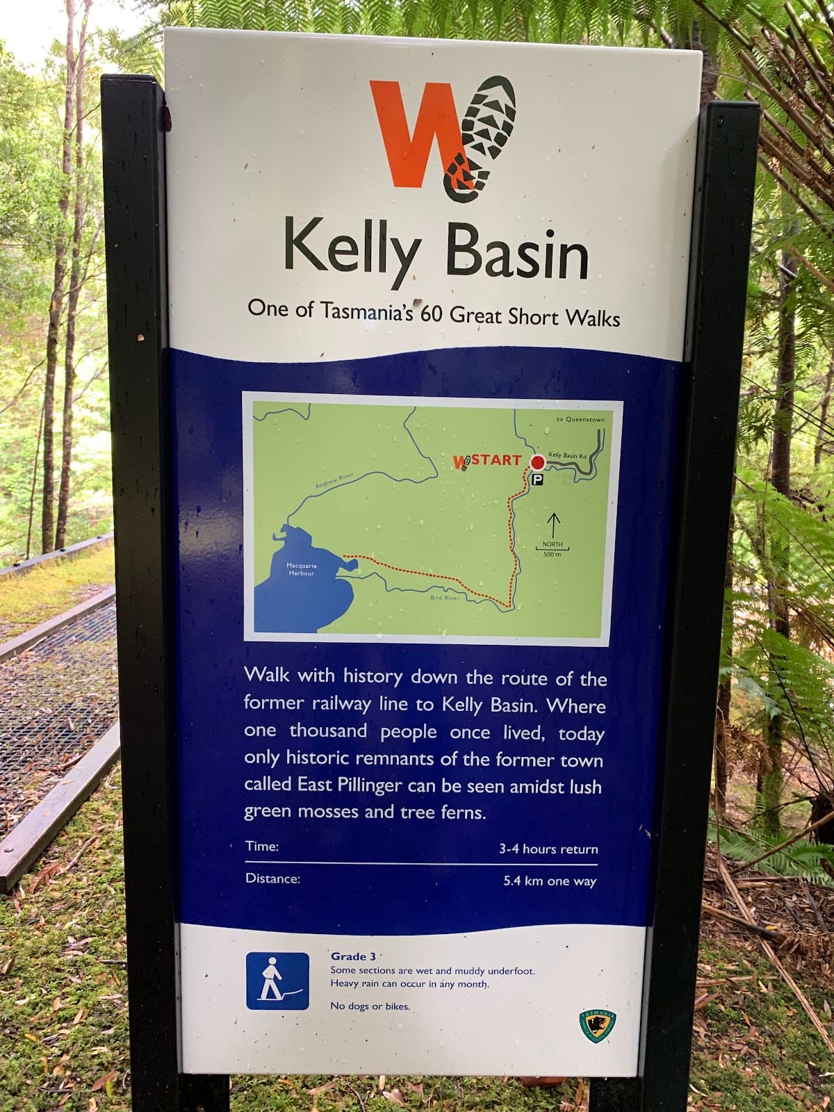
Bird River Track and Pillinger
A captivating rainforest hike leading to the historical ruins of Pillinger, offering stunning river and harbour views.
Highlights
Must-see attractions

Social
From TikTok & Reddit
Best Time
Minimizes mud on the track
Bird River Track and Pillinger
Best Time
Minimizes mud on the track
Highlights
Must-see attractions
A captivating rainforest hike leading to the historical ruins of Pillinger, offering stunning river and harbour views.
"Excellent day walk, thoroughly recommend for its unique blend of nature and history."

🥾 Wear Sturdy Boots
Waterproof hiking boots are a must for the muddy and root-filled sections.
🚗 2WD Accessible Road
The road to the car park has improved; 2WD is generally fine with care, despite some signs.

Highlights
Discover the most iconic attractions and experiences
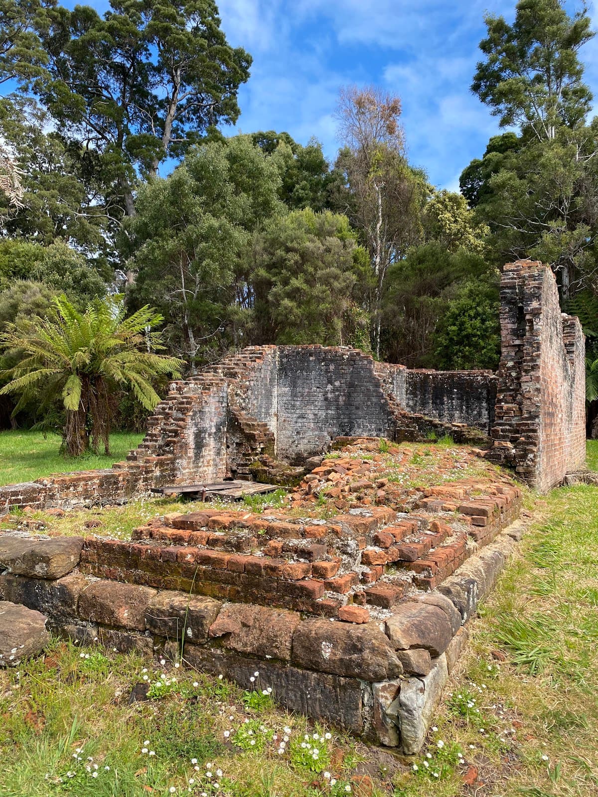
Pillinger Ruins
End of the track
Explore the remnants of an old mining town, including relics and a National Parks Jetty overlooking Macquarie Harbour.
Macquarie Harbour Views
Near Pillinger
Enjoy scenic vistas of Macquarie Harbour, a perfect spot for a picnic lunch amidst the wilderness.

Lush Rainforest Walk
Along the track
Immerse yourself in a beautiful rainforest environment, abundant with mosses and ferns, following the Bird River.
Plans like a pro.
Thinks like you
Planning Your Visit
Prepare for Muddy Trails
Allow Ample Time for Exploration
Best Times
Insider Tips
from TikTok, Instagram & Reddit
🥾 Wear Sturdy Boots
Waterproof hiking boots are a must for the muddy and root-filled sections.
🚗 2WD Accessible Road
The road to the car park has improved; 2WD is generally fine with care, despite some signs. +1
⏱️ Allow 6+ Hours
Factor in time for the 16km walk, exploring ruins, and photography.
🗺️ Follow River for 3/4
The track largely follows the Bird River, offering scenic water views.
Tips
from all over the internet
🥾 Wear Sturdy Boots
Waterproof hiking boots are a must for the muddy and root-filled sections.
🚗 2WD Accessible Road
The road to the car park has improved; 2WD is generally fine with care, despite some signs. +1
⏱️ Allow 6+ Hours
Factor in time for the 16km walk, exploring ruins, and photography.
🗺️ Follow River for 3/4
The track largely follows the Bird River, offering scenic water views.
🚻 Toilet Near Jetty
There's a toilet facility available near the National Parks Jetty at Pillinger.
What Travellers Say
Reviews Summary
Visitors praise the Bird River Track and Pillinger for its excellent day walk potential, offering a unique blend of rainforest immersion and historical exploration. The scenic beauty and the chance to discover the remnants of an old town are frequently highlighted. However, the track's notorious mud and root-filled sections require sturdy footwear and can make the hike challenging, especially after rain.
"Excellent day walk. Thoroughly recommend. After 20mm of rain over two days at Queenstown the track was slush in places. Notes:
60min/40Km drive from Queenstown to car park
Road has improved since guidebook and sign and is 2WD accessible with a bit of care and ground clearance. Contrary to sign at start stating 5.4km each way, we measured 6.9km on GPS app. A real river walk following it for 3/4 of the walk.
In the really wet spots, look out for the well used alternative bypasses on the river side ( Up on a bank in some places).
We spent about 30mins looking through the ruined township and found the best spot for lunch was near the National Parks Jetty and over looked Macquarie Harbour.
There is a toilet near the Jetty."
BnJ Neburnum2
"Beautiful day out, nice flat walk but do need really good firm boots, lots of obstacles, rocks & tree roots, and lots and lots of mud, with all the beautiful ferns surprisingly not one leach! 16km return from car park, 2 hrs each way if you want to walk and not sight see.... i would probably allow for 6+ for the whole walk.... but I love to take photos... as you can see!"
Laura Foster
"Though it's listed as one of the 60 great short hikes in Tasmania, there's not much information on how to get there/what to expect. Keep driving on the Mt. Jukes Rd until you see a sign that says "Franklin-Gordon Wild Rivers National Park". The road gets narrow and bumpy, but keep driving for another 30-40 min (will see 4WD only sign on the way; we weren't 4WD but it turned out okay) then you'll finally get to the Bird River Bridge. This is where the trail starts. The trail itself was pretty plain and easy-- not much going up-- but some parts can be muddy and slippery. You'll get to experience the beautiful rainforest full of mosses and ferns. We are moderately fit people and it took us 1.5 hour one way. Almost at the end, there is a sign that explains the history of the old town Pillinger; you will see some relics of the town. All in all it was a decent, peaceful short hike perfect for half day. Would recommend if you're nearby."
Eunsun Lee
What People Like
What People Dislike
Frequently Asked Questions
🚇 🗺️ Getting There
The drive from Queenstown to the Bird River Track car park is about 60 minutes (40km). Continue on Mt. Jukes Rd until you see the Franklin-Gordon Wild Rivers National Park sign. The road can be narrow and bumpy, but 2WD vehicles can manage with care. +1
While some signs suggest 4WD is recommended, many visitors report that 2WD vehicles can navigate the road with caution, especially after recent improvements. +1
The trail begins at the Bird River Bridge, which you'll reach after driving for about 30-40 minutes on the Mt. Jukes Rd from the main park sign.
Yes, there is a car park at the trailhead near the Bird River Bridge where you can leave your vehicle before starting the hike.
The drive from Queenstown to the trailhead takes approximately 60 minutes, covering about 40 kilometers.
🎫 🎫 Tickets & Entry
No, the Bird River Track is part of the Franklin-Gordon Wild Rivers National Park and does not require an entry fee or tickets.
The track is open year-round and accessible at any time. However, it's best to hike during daylight hours for safety and to enjoy the scenery.
There is no entrance fee for the Franklin-Gordon Wild Rivers National Park, making the Bird River Track a free activity.
Yes, the track is accessible on public holidays. It's advisable to check local conditions beforehand, as some services might have altered hours.
No booking is required for the Bird River Track. It's a self-guided hike, so you can visit anytime.
🎫 🧭 Onsite Experience
The Bird River Track is approximately 6.9 kilometers one way, making it a 13.8 km return trip from the car park. +1
If you walk without stopping, it can take about 2 hours each way. However, allowing 6+ hours is recommended to explore Pillinger and take photos.
The track can be muddy and slippery, especially after rain. It features rocks, tree roots, and some very wet spots. Look for bypasses in muddy areas. +1
The track is relatively flat with not much elevation gain, making it manageable for moderately fit individuals. However, the muddy conditions require good footwear and some care.
You'll experience a beautiful rainforest with abundant mosses and ferns, and the track follows the Bird River for about three-quarters of the way.
📸 📸 Photography
Capture the lush rainforest with its mosses and ferns, the winding Bird River, and the historical ruins of Pillinger. The views of Macquarie Harbour are also stunning. +1
Absolutely! The unique rainforest environment and the historical remnants of Pillinger offer fantastic photographic subjects.
Daytime offers the best light for capturing the vibrant greens of the rainforest. Early morning or late afternoon can provide softer light and interesting shadows.
The National Parks Jetty overlooking Macquarie Harbour provides a particularly scenic spot for photos.
A wide-angle lens is great for the rainforest, while a telephoto can be useful for details in the ruins. Consider a tripod for low-light conditions or capturing water movement. A waterproof bag is also advisable due to potential mud and rain.
For Different Travelers
Tailored advice for your travel style
👨👩👧 Families with Kids
🚶 Budget Travelers
📸 Photography Enthusiasts
Deep Dives
In-depth insights and expert knowledge
Navigating the Road to the Trailhead
It's wise to check recent road conditions if possible, especially after significant rainfall. The drive offers a sense of remoteness and builds anticipation for the hike ahead. Remember to allow ample time for this part of your journey so you can start the track feeling relaxed and prepared.
The Historical Significance of Pillinger
Taking time to wander through the ruins provides a unique perspective on Tasmania's industrial history. It's a chance to imagine life in this remote settlement and appreciate the efforts of those who worked and lived here. The peaceful setting now contrasts sharply with its former industrious nature, making it a compelling stop for history buffs and curious travelers alike.
What to Expect on the Track Itself
Be prepared for obstacles like rocks and tree roots, which are common on forest trails. In particularly wet areas, observant hikers will notice well-trodden bypasses that offer slightly drier passage.


Social
from TikTok, Instagram & Reddit