
Cape to Cape Track Northern Section
Hike through diverse ecosystems along WA's stunning coast, from sandy beaches to forest, with accessible options.
Highlights
Must-see attractions
Social
From TikTok & Reddit
Best Time
Wildflowers bloom, mild temps
Cape to Cape Track Northern Section
Best Time
Wildflowers bloom, mild temps
Highlights
Must-see attractions
Hike through diverse ecosystems along WA's stunning coast, from sandy beaches to forest, with accessible options.
"Amazing walk through 3 different ecosystems in just 2 hours!"
💧 Hydration is Key
Carry at least 3L of water per person, especially in warmer months. Dehydration is a serious risk.
👟 Prepare for Sand
Sections of the track are sandy, which can be challenging. Wear supportive footwear and be ready for a workout.
Highlights
Discover the most iconic attractions and experiences
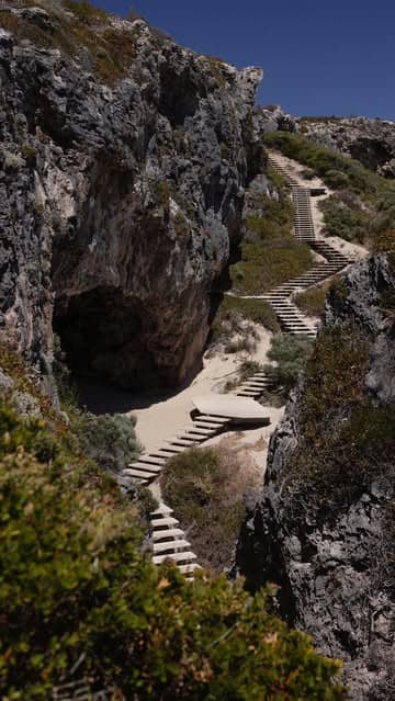
Bob's Hollow Coastal Views
North of Conto's
Experience upgraded boardwalks and steps offering stunning coastal vistas. Perfect for a scenic stroll or part of a longer trek.
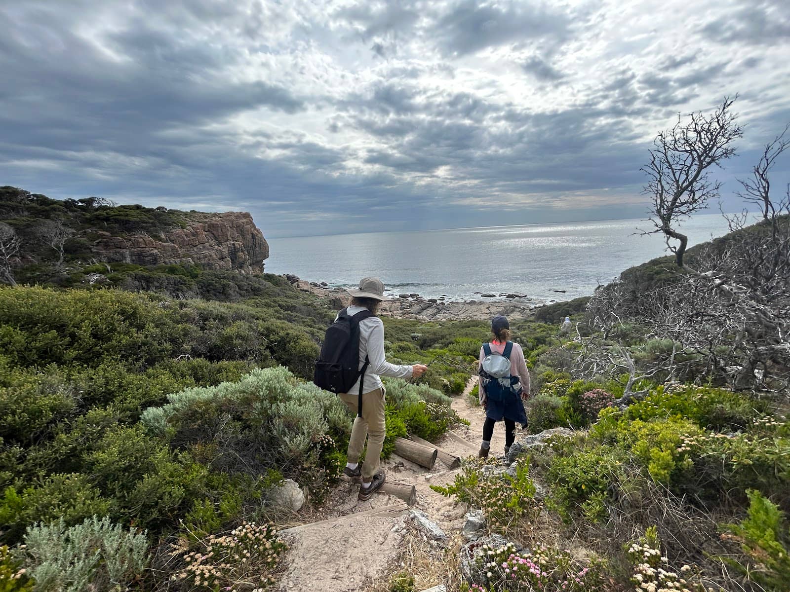
Diverse Ecosystems
Various points along the track
Hike through three distinct natural environments, from coastal heath to forest, showcasing the region's biodiversity.
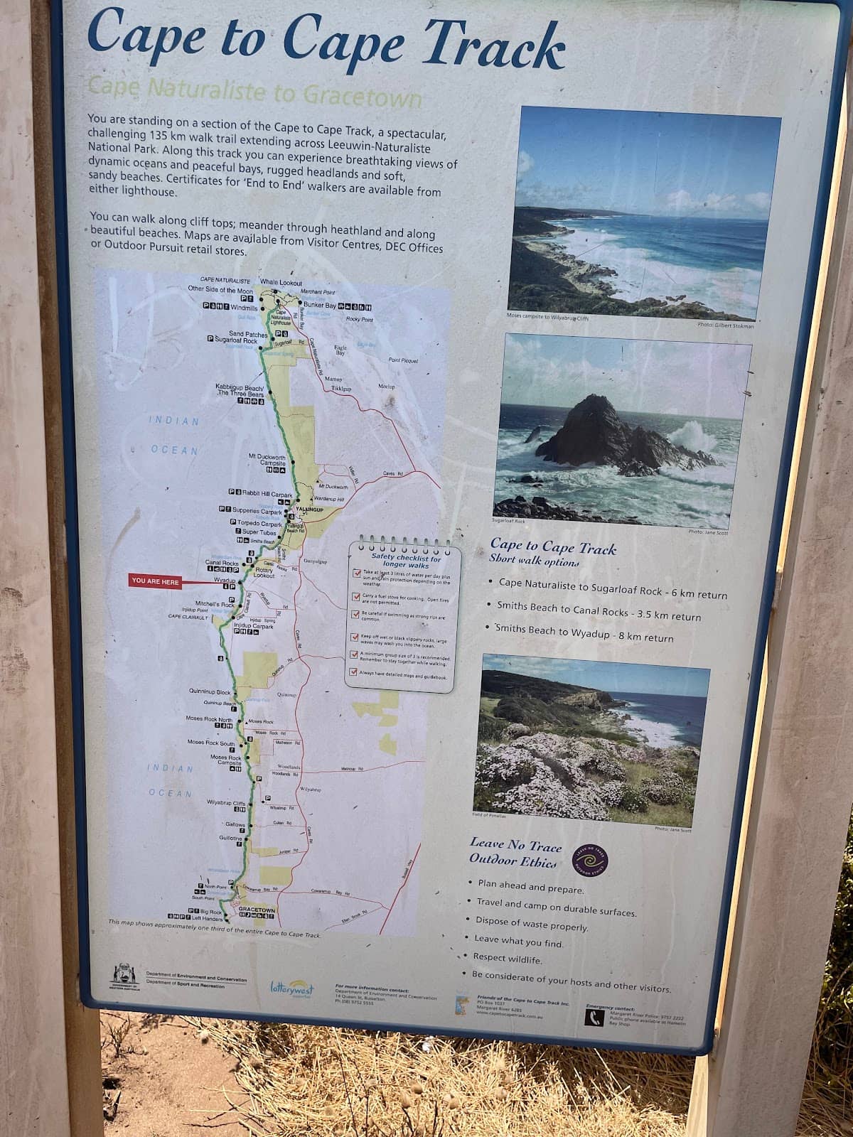
Grace Town to Cape Naturaliste
Northern Section
A popular 45km stretch offering varied terrain, including challenging soft sand sections with rewarding ocean panoramas.
Plans like a pro.
Thinks like you
Planning Your Visit
Beat the Heat and Fire Risk
Segment Your Adventure
Best Times
Insider Tips
from TikTok, Instagram & Reddit
💧 Hydration is Key
Carry at least 3L of water per person, especially in warmer months. Dehydration is a serious risk.
👟 Prepare for Sand
Sections of the track are sandy, which can be challenging. Wear supportive footwear and be ready for a workout.
Just over a week ago I solo hiked the Cape to Cape Trail (~130km's) in South West WA. I couldn't believe some of the scenery on this trail.
Cape to Cape in Feb - will it be too hot?
🚶♀️ Break it Down
Easily divide the track into shorter day walks using numerous vehicle access points.
⬆️ Hike in Reverse?
Some find walking the harder sections first (reverse direction) offers better scenery.
Margaret River region recommendations
Tips
from all over the internet
💧 Hydration is Key
Carry at least 3L of water per person, especially in warmer months. Dehydration is a serious risk.
👟 Prepare for Sand
Sections of the track are sandy, which can be challenging. Wear supportive footwear and be ready for a workout.
🚶♀️ Break it Down
Easily divide the track into shorter day walks using numerous vehicle access points.
⬆️ Hike in Reverse?
Some find walking the harder sections first (reverse direction) offers better scenery.
♿ Accessible Options
The northern section offers wheelchair-accessible paths, making it inclusive for more visitors.
What Travellers Say
Reviews Summary
Visitors rave about the Cape to Cape Track's stunning natural beauty, diverse ecosystems, and rewarding coastal views. The ability to break it into manageable day walks and the accessibility of parts of the northern section are highly appreciated. However, some find the sandy terrain challenging, and summer heat requires careful planning for hydration and safety.
"Amazing walk, walked through 3 different ecosystems in the 2hr walk. We walked it in reverse which was amazing got to see the scenery and walk the harder sections first (thank goodness)
Hike: Mod-Hard
Distance: 7.3km
Elevation: 146m
Definitely worth it."
Ben Forbes
"This trail is an amazing spectacle of the southwest. While the days can be long and the soft sand difficult, it showcases the amazing landscape of the area. Bring at least 3L of water per day. I recommend hiking it in 6 days if you are quite fit, 7 if you want to take your time. There is places to get fresh food along the way so you don’t need to pack for all 6 days. Enjoy!!"
Pat
"Great and beautiful track, track is quite sand in sections. Did the first 45km from Cape Naturalist to Grace Town."
C Presto
What People Like
What People Dislike
Frequently Asked Questions
🚇 🗺️ Getting There
The northern section is accessible from various points, including near Cape Naturaliste and Grace Town. Many vehicle access points allow you to start or end your hike at different locations, making it easy to plan day walks.
Public transport options are limited. It's generally recommended to have your own vehicle or arrange a shuttle service for multi-day hikes or to reach specific trailheads. Research local shuttle providers in the Margaret River region.
Yes, there are numerous parking areas and vehicle access points along the northern section, allowing you to drive directly to many trailheads for day hikes.
The northern section begins near Cape Naturaliste Lighthouse. Driving from Perth, it's approximately a 3-hour journey south-west. Consider flying into Busselton Regional Airport for a shorter drive.
Parking is generally available at popular trailheads like Cape Naturaliste. For longer hikes, consider parking at one end and arranging transport back from the other, or using designated overnight parking if available and permitted.
🎫 🎫 Tickets & Entry
No, the Cape to Cape Track is a public trail and does not require tickets for entry. You can access and walk it freely.
While the track itself is free, there might be parking fees at some national park entry points or associated facilities. It's always good to check local signage.
The track is open 24/7. However, it's best to hike during daylight hours for safety and to fully appreciate the scenery.
No booking is required for day hikes. You can start your walk at any accessible point. For multi-day hikes, it's advisable to book accommodation in advance if using established campsites or nearby towns.
Camping is generally not permitted along the track itself. Designated campsites or accommodation should be booked in advance in nearby towns or caravan parks.
🎫 compass Onsite Experience
The northern section offers varied difficulty. Some parts are moderate, while others, particularly sandy sections, can be challenging. Reviews suggest a 'Mod-Hard' rating for certain segments.
The northern section can be hiked in segments. A 7.3km walk is described as taking around 2 hours. For the full 123km track, fit hikers might take 6 days, while others prefer 7 days to take their time.
Yes, with its accessible sections and shorter walk options, families can enjoy parts of the northern section. The diverse scenery is engaging for children.
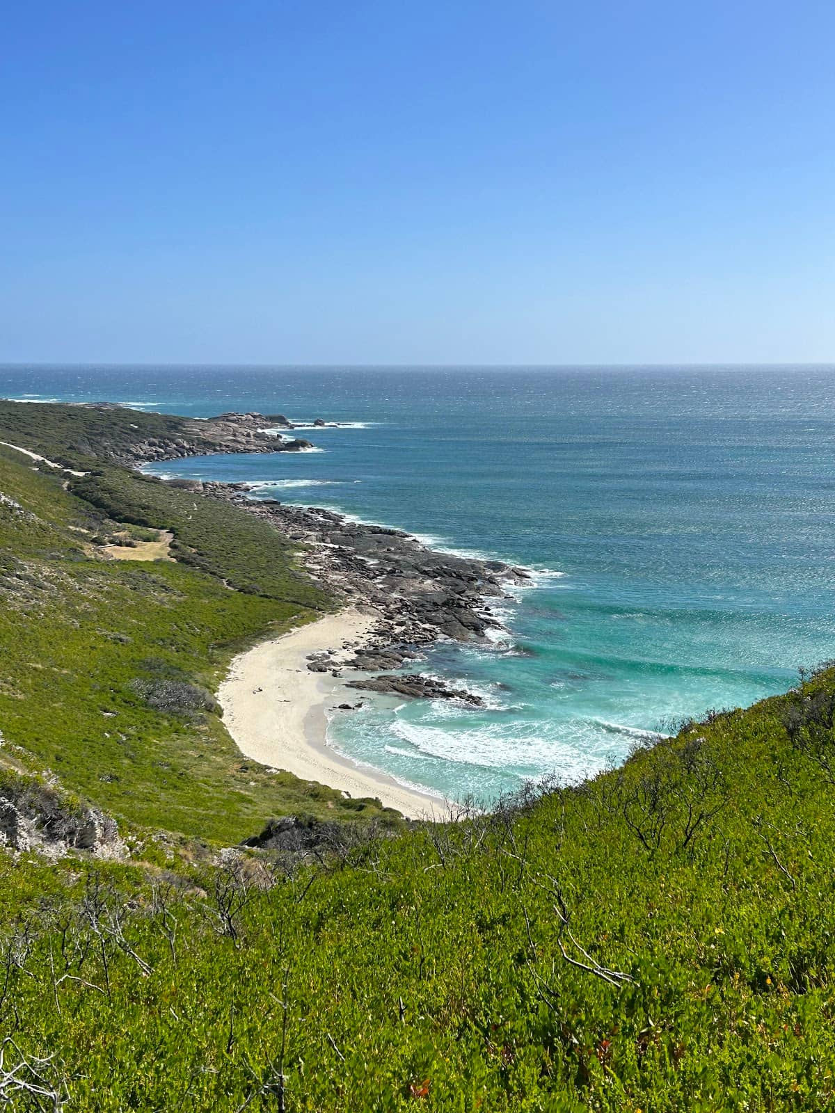
Expect to traverse through three different ecosystems, including coastal heath, forests, and dramatic ocean views. Bob's Hollow offers particularly impressive coastal vistas.
Facilities vary. Some popular trailheads and campsites may have toilets. Water sources are scarce, so carrying ample water is crucial.
📸 camera_with_flash Photography
Capture stunning coastal landscapes, especially around Bob's Hollow. Look for dramatic ocean vistas, unique flora, and the diverse ecosystems the track traverses. Sunrise and sunset can offer spectacular light.
The 'golden hours' around sunrise and sunset provide the most dramatic and flattering light for landscape photography. Midday sun can be harsh.
Bob's Hollow is frequently highlighted for its epic views. Also, keep an eye out for elevated sections offering panoramic ocean panoramas, particularly between Cape Naturaliste and Grace Town.
A wide-angle lens is great for capturing expansive landscapes. A telephoto lens can be useful for wildlife. Consider a sturdy tripod for low-light conditions or long exposures.
Drone usage is subject to national park regulations. Always check with Parks and Wildlife Service WA for current rules and restrictions before flying a drone in the area.
For Different Travelers
Tailored advice for your travel style
👨👩👧 Families with Kids
Focus on the diverse scenery to keep children engaged – from coastal heath to forest pockets. Pack plenty of snacks and water, as facilities can be sparse. The sandy sections can be fun for kids to play in, but also challenging, so manage expectations and perhaps choose flatter, firmer paths for younger children. The ease of access means you can tailor the hike to your family's energy levels and interests, ensuring a memorable and enjoyable outdoor adventure.
🚶♀️ Budget Travelers
Consider packing your own lunches and snacks to avoid purchasing food at potentially higher prices in tourist areas. If you're planning a multi-day experience, look for affordable camping options or hostels in nearby towns like Margaret River or Augusta, rather than pricier hotels. Utilizing the numerous access points means you can customize your hikes to be as short or as long as you like, without needing expensive guided tours.
Deep Dives
In-depth insights and expert knowledge
Navigating the Terrain
For those seeking a more accessible experience, the northern section does offer wheelchair-accessible paths.
When planning your hike, consider the time of year. Summer, especially February, can be extremely hot, making the sandy sections even more arduous and increasing the risk of dehydration.
Seasonal Considerations and Safety
Spring (September to November) is often considered one of the best times to visit. The weather is typically mild and pleasant, and the landscape bursts into bloom with wildflowers, offering a visually spectacular experience. Autumn (March to May) also provides excellent hiking conditions with cooler temperatures and fewer crowds than the peak spring season. Winter (June to August) can bring rain and wind, making for a more rugged experience, but also offers dramatic coastal storm views for the prepared.
Regardless of the season, always be prepared. Carry ample water, especially during warmer months.


Social
from TikTok, Instagram & Reddit