Cape to Cape Track
An 84-mile coastal trail in WA, offering diverse scenery from beaches to forests, connecting two iconic lighthouses.
Highlights
Must-see attractions

Social
From TikTok & Reddit
Best Time
Wildflowers bloom vibrantly
Cape to Cape Track
Best Time
Wildflowers bloom vibrantly
Highlights
Must-see attractions
An 84-mile coastal trail in WA, offering diverse scenery from beaches to forests, connecting two iconic lighthouses.
"One of Australia's finest coastal walks with spectacular and varied scenery."

👣 Blister Prevention
Use double socks, keep feet dry, and take care. Blisters can end your hike early!
🚶♀️ Take Your Time
Don't rush! The spectacular scenery is meant to be savored.

Highlights
Discover the most iconic attractions and experiences
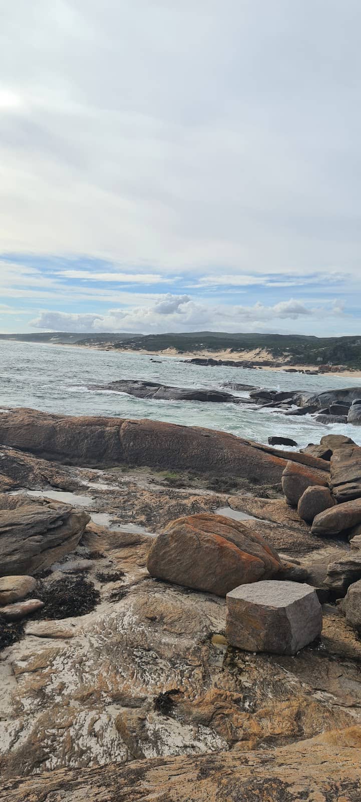
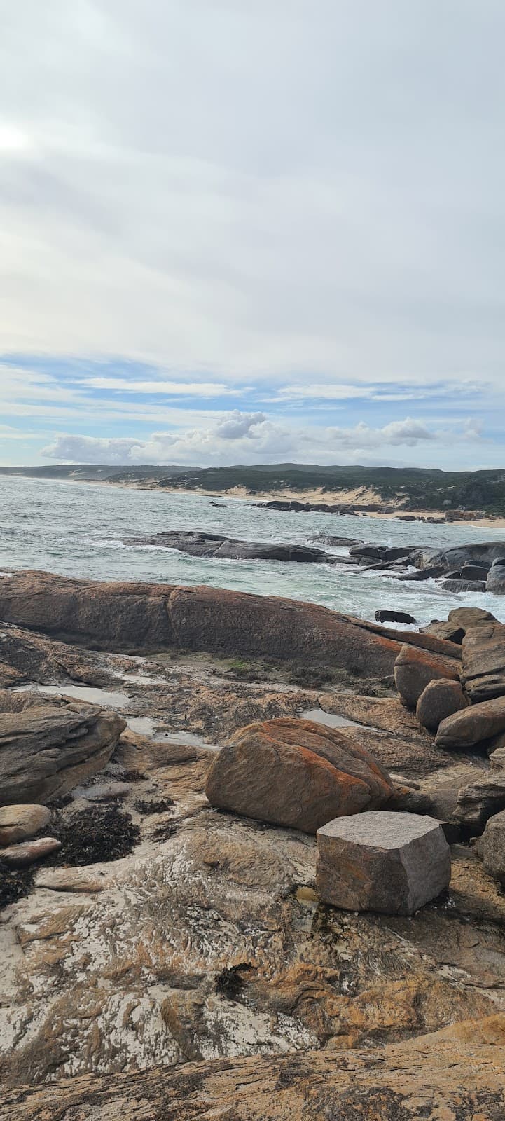
Bob's Hollow
Between Contos and Bob's Hollow
Stunning coastal views with newly upgraded wooden steps, perfect for a scenic stroll.
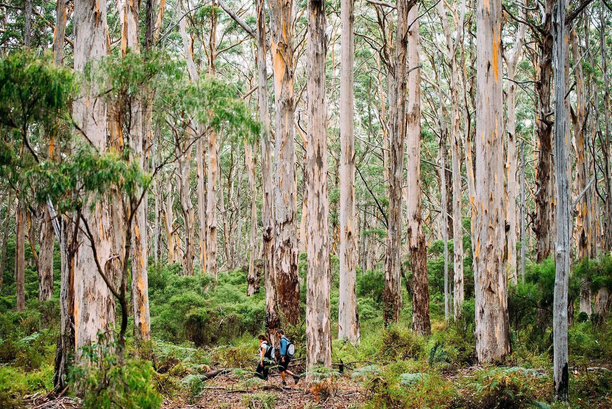
Boranup Forest
Southern section of the track
Walk beneath towering Karri trees for a magical, shaded contrast to the coastal paths.
Cape Naturaliste Lighthouse
Northern terminus
A heritage-listed lighthouse marking the start of this epic coastal adventure.
Cape Leeuwin Lighthouse
Southern terminus
The iconic endpoint where the Indian and Southern Oceans meet, offering panoramic vistas.
Plans like a pro.
Thinks like you
Planning Your Visit
Foot Care is Key
Plan Your Sections
Best Times
Insider Tips
from TikTok, Instagram & Reddit
👣 Blister Prevention
Use double socks, keep feet dry, and take care. Blisters can end your hike early!
🚶♀️ Take Your Time
Don't rush! The spectacular scenery is meant to be savored.
🌊 Coastal & Forest Mix
Experience varied terrain: beaches, dunes, cliffs, and Karri forests.
☀️ Hydration is Key
Carry plenty of water, especially during warmer months.
Tips
from all over the internet
👣 Blister Prevention
Use double socks, keep feet dry, and take care. Blisters can end your hike early!
🚶♀️ Take Your Time
Don't rush! The spectacular scenery is meant to be savored.
🌊 Coastal & Forest Mix
Experience varied terrain: beaches, dunes, cliffs, and Karri forests.
☀️ Hydration is Key
Carry plenty of water, especially during warmer months.
💡 Section Hiking
Consider hiking specific sections like Contos to Bob's Hollow for amazing views.
What Travellers Say
Reviews Summary
Visitors rave about the Cape to Cape Track's stunning and diverse coastal scenery, from pristine beaches to dramatic cliffs and enchanting forests. The well-maintained paths and the iconic lighthouses at either end are frequently praised. However, some find the sandy sections challenging, and the lack of facilities and water sources on certain stretches requires careful planning.
What People Like
What People Dislike
Frequently Asked Questions
🚇 🗺️ Getting There
The track is located in the Margaret River region of Western Australia. The closest major airport is Perth Airport (PER). From Perth, you can rent a car and drive south (approx. 3 hours) to reach the start points like Cape Naturaliste or Dunsborough. Public transport options are limited, so a car is highly recommended for accessing different trailheads and for logistics if you're not doing a guided tour.
Access points are available at various beaches and towns along the 123km route. Popular starting points include Cape Naturaliste, Dunsborough, Gracetown, and Contos. Many sections are accessible by car, making it feasible to hike out-and-back or arrange for drop-offs/pick-ups.
Absolutely! Many visitors opt for day hikes. Sections like Bob's Hollow to Contos offer stunning coastal scenery and are popular for shorter walks. You can easily find trail maps online to identify suitable day hike sections based on your fitness and desired views.
Renting a car is the most convenient option for exploring the Margaret River region and accessing various trailheads of the Cape to Cape Track. This gives you the flexibility to start and end your hikes at different points.
While not as common as in some other major hiking destinations, some local tour operators or private services may offer shuttle options for hikers needing transport between trailheads. It's best to research and book these in advance.
🎫 🎫 Tickets & Entry
No, the Cape to Cape Track is a public, free-access trail. There are no entry fees or tickets required to walk any section of the track.
Camping is generally not permitted along the main Cape to Cape Track itself, except in designated campgrounds that may require booking and fees. It's essential to check with the relevant authorities (like Parks and Wildlife Service WA) for current regulations on camping and any associated permits.
The track is open 24/7, year-round. However, it's advisable to hike during daylight hours for safety and to fully appreciate the scenery.
While the track itself is free, there might be an entry fee to climb or tour the Cape Naturaliste and Cape Leeuwin Lighthouses. Check their official websites for current admission prices and opening times.
Dogs are generally not permitted on the Cape to Cape Track, especially in national park areas, to protect native wildlife. Always check local signage and regulations.
🎫 🚶♀️ Onsite Experience
Thorough preparation includes researching trail conditions, packing appropriate gear (sturdy hiking boots, sun protection, water, snacks), and understanding the terrain. Foot care is paramount to prevent blisters, so consider double socks and blister prevention strategies.
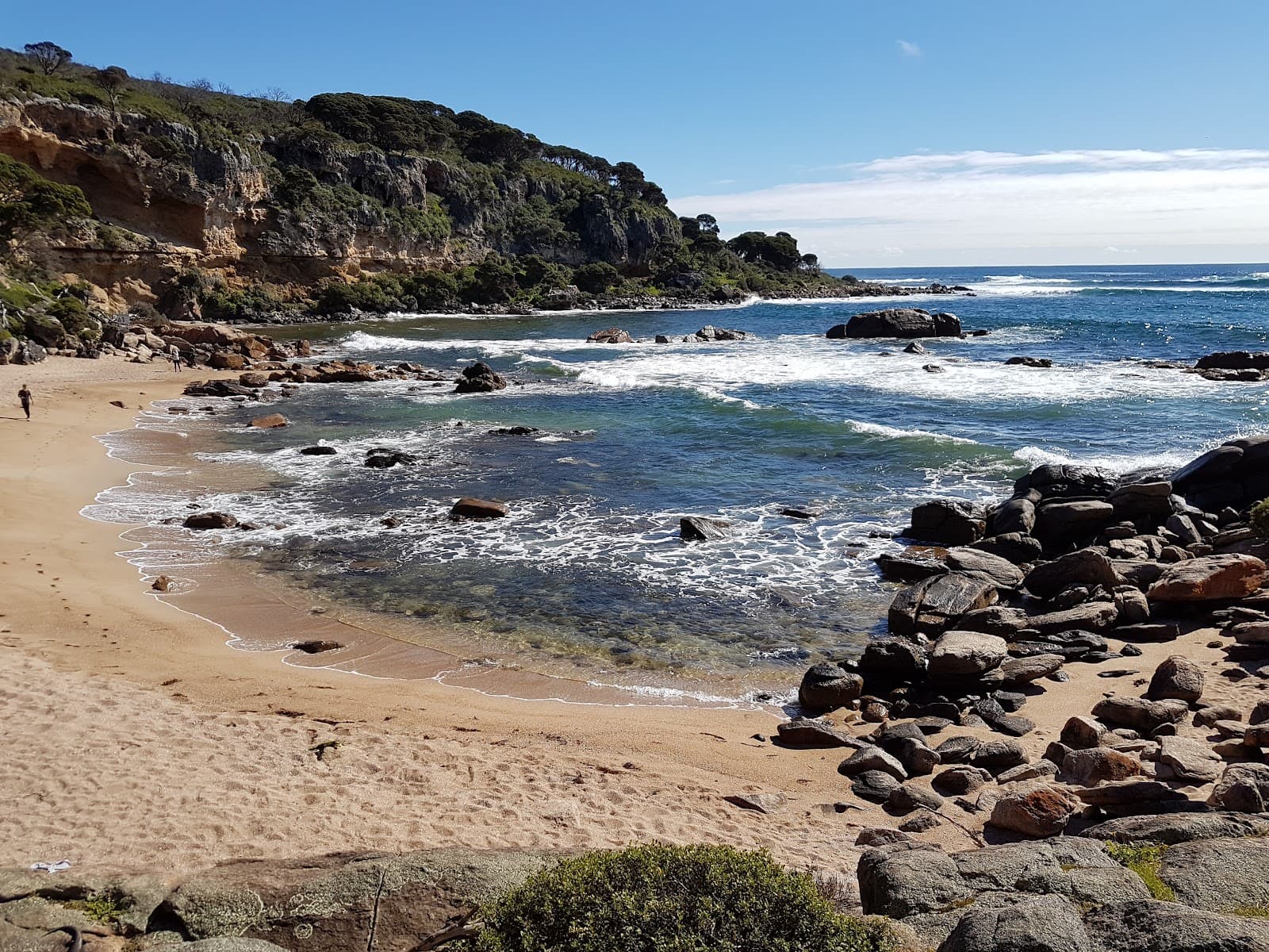
The terrain is incredibly varied, featuring sandy beaches, coastal dunes, rocky cliff faces, and dense Karri forest. Some sections have boardwalks or steps, while others are more rugged. +1
The track is generally well-marked with signage, particularly the main 123km route. However, it's always wise to carry a map or use a GPS device, especially if venturing onto less-trafficked sections or in poor visibility.
You can encounter abundant plant and wildlife, including wildflowers in spring, various bird species, and marine life along the coast. Keep an eye out for kangaroos and other native Australian animals.
Facilities vary by section. Some popular access points and campgrounds have toilets. Water sources can be scarce, so carrying sufficient water is essential. Plan your stops and resupply points carefully.
🍽️ 🍽️ Food & Dining
Dining options are limited directly on the trail itself. You'll find cafes and restaurants in towns like Dunsborough, Gracetown, and Augusta. It's best to pack your own food and snacks for longer hikes.
For day hikes, pack energy-rich snacks like trail mix, fruit, energy bars, and sandwiches. Ensure you have enough food to sustain you for the duration of your walk.
While some individuals have attempted foraging, it's generally not recommended for casual hikers due to safety concerns and potential environmental impact. Stick to packed provisions unless you have expert knowledge.
Yes, the area around Cape Naturaliste and the nearby town of Dunsborough offers various dining options, from casual cafes to more formal restaurants.
Augusta, located at the southern end of the track near Cape Leeuwin, has several restaurants and cafes offering fresh local produce and seafood.
📸 📸 Photography
Everywhere! The track offers incredible photo opportunities, from dramatic coastal cliffs and pristine beaches to the majestic Boranup Forest. Sunrise and sunset cast a magical light on the landscape.
The 'golden hours' – shortly after sunrise and before sunset – provide the most dramatic and flattering light for landscape photography. Midday sun can be harsh.
A smartphone camera is perfectly adequate for capturing the beauty of the track. However, if you're serious about landscape photography, a DSLR or mirrorless camera with a wide-angle lens will be beneficial.
Yes, the views from the cliff tops near Bob's Hollow, the entrance to Boranup Forest, and the lighthouses at both ends are particularly photogenic. +1
Bring a sturdy camera bag to protect your gear from sand and salt spray. A polarizing filter can help manage glare on the water and enhance sky colors. A lightweight tripod can be useful for low-light shots.
For Different Travelers
Tailored advice for your travel style
👨👩👧 Families with Kids
For families looking for a more immersive experience, consider booking a guided tour that caters to families or focusing on sections with easier access and amenities. The Boranup Forest section can also be a hit, offering a sense of adventure under the tall trees. Remember to check for any specific restrictions regarding children or strollers on certain parts of the track.
🚶 Budget Travelers
Packing your own food and water for day hikes or multi-day treks is significantly more economical than relying on cafes and restaurants. If you're traveling solo, consider joining a group hike or looking for fellow travelers to share transport costs. Many sections are accessible without needing expensive guided tours, allowing for a self-sufficient and affordable adventure.
📸 Photography Enthusiasts
Don't miss the golden hours around sunrise and sunset for the most magical light. Experiment with wide-angle lenses to capture the expansive scenery and consider a polarizing filter to enhance the blues of the ocean and sky. The lighthouses at Cape Naturaliste and Cape Leeuwin also make for iconic photographic subjects.
Deep Dives
In-depth insights and expert knowledge
Planning Your Cape to Cape Adventure
When planning, consider the time of year. Spring (September to November) is ideal for wildflower enthusiasts, while autumn (March to May) offers milder weather and fewer crowds. Summer can be very hot, making early morning or late afternoon hikes essential. For multi-day treks, booking accommodation or campsites in advance is highly recommended, as options can be limited.
Foot care is a recurring theme among seasoned hikers. Blisters can significantly impact your experience, so investing time in proper foot preparation, including wearing well-fitted hiking boots and using double socks, is crucial. Taking your time to enjoy the breathtaking views rather than rushing is also a common piece of advice from those who have completed the track.
Highlights of the Cape to Cape Track
Further south, the Boranup Forest provides a stunning contrast to the coastal paths. Walking beneath the towering Karri trees offers a serene and shaded experience, a welcome respite on warmer days.
The track's termini are also significant landmarks. The Cape Naturaliste Lighthouse marks the northern beginning, offering panoramic views of the coastline. At the southern end, the Cape Leeuwin Lighthouse, where the Indian and Southern Oceans converge, provides a dramatic and fitting conclusion to the journey.
Navigating and Staying Safe
Safety is paramount. Always inform someone of your hiking plans, including your intended route and expected return time. Carry a fully charged mobile phone, though reception can be patchy in some areas. Be aware of tides and sea conditions, particularly when walking along beaches. In warmer months, sun protection (hat, sunscreen, sunglasses) and ample hydration are non-negotiable.
While the track is free to access, respecting the environment is crucial. Stick to marked paths to minimize erosion and protect native flora and fauna. Pack out everything you pack in, leaving no trace behind.


Social
from TikTok, Instagram & Reddit